Highlights:
Rough, rocky mountains east of Phoenix, covered by saguaro and other cacti, and split by many canyons. Excellent hiking opportunities. Contain several lakes and camping areas
Nearby towns:
Management:
USFS - part of Tonto National Forest
Location:
33.397, -111.347 (Peralta Road trailhead)
Seasons:
Winter, spring and fall are best, as summers are very hot
Rating (1-5):
★★★★★

The Superstition Mountains are part of the Indian Lands itinerary
Featured Hotel
Best Western Apache Junction Inn
 Popular, affordable hotel built in the traditional Southwest adobe style, along the Apache Trail just six miles from the west edge of the mountains
Check Rates
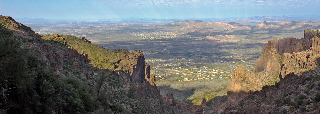
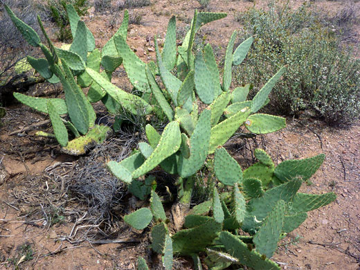
The Superstitions are the largest of the mountain ranges surrounding Phoenix, visible from many miles away along the straight roads through the suburbs east of Mesa. They rise steeply above the flat desert to a high point of 5,024 feet, and are characterized by sheer-sided, jagged, volcanic peaks and ridges separated by boulder-filled canyons, all covered by saguaro at low elevations, with other cacti and bushes higher up. Trees are found only at scattered locations, at springs or beside streamways. Early settlers named the hills on account of the many myths and stories told by the local Pima/Apache Indians about the mountains, and tales such as the fabled Lost Dutchman gold mine.
Most of the mountains are within the Tonto National Forest, and a large part is further protected as the Superstition Wilderness, the closest large pristine area to Phoenix and so a very popular hiking destination, though there are relatively few easy trails - most routes are quite long and strenuous, especially during the hot weather that prevails most of the year.
Most of the mountains are within the Tonto National Forest, and a large part is further protected as the Superstition Wilderness, the closest large pristine area to Phoenix and so a very popular hiking destination, though there are relatively few easy trails - most routes are quite long and strenuous, especially during the hot weather that prevails most of the year.
Superstition Mountains Table of Contents
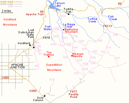
- Trail map for the Superstition Mountains
- Tours of the Apache Trail
- Photographs
- Introduction
- Trails of the Superstition Mountains and the west Superstition Wilderness
- Featured hikes
- Nearby places
- Similar places
Superstition Mountains Trail Map
Apache Trail Tours
Photographs
16 general views of the Superstition Mountains.
Introduction
The wilderness extends eastwards from the Superstition range to other more remote mountains, and for all this region access is limited to two main roads; US 60 past the southern edge and the Apache Trail (AZ 88) to the north. There are four trailheads for the most visited western half that includes the Superstition Mountains; at the end of Peralta Road (FR 77, a good quality 8 mile gravel track starting near Gold Canyon), First Water Road (FR 78) branching off AZ 88 near Goldfield, Canyon Lake Marina, and FR 213, a rough track south from the Apache Trail a few miles beyond Tortilla Flat. For an introduction to the mountains, several short trails start from the Lost Dutchman State Park near Apache Junction.
Trails of the Superstition Mountains and the west Superstition Wilderness
| Trail (with number) |
Length (one way) (miles) |
Elevation Change (feet) |
Trail Description |
| Siphon Draw #53 |
2 | 1,000 | One of four trails in or near the Lost Dutchman State Park, the Siphon Draw Trail climbs a ravine for good views over the western edge of the Superstition Mountains, and the Apache Junction suburbs. |
| Treasure Loop #56 |
2.4 | 500 | This easy path encounters forests of saguaro cacti, grasslands and rocky outcrops as it loops around the hillside above Lost Dutchman State Park. |
| Prospector's View #57 |
0.7 | 300 | The short Prospector's View Trail links #53 with #56, through a rocky area in the mountain foothills. |
| Jacob's Crosscut #58 |
6.5 | 400 | A long but mostly near level route, the Jacob's Crosscut Trail runs beneath the west face of the Superstition Mountains, over cactus slopes and across several dry washes, always with wide-ranging views over Apache Junction. |
| Hieroglyphic #101 |
1.5 | 650 | Beginning at the end of a residential street north of Gold Canyon, this short path leads up Hieroglyphic Canyon to a group of petroglyphs beside some seasonal pools. |
| Peralta #102 |
6.2 | 1,360 | The most popular path in the Superstitions is the Peralta Trail, which starts at the end of Peralta Road and climbs up Peralta Canyon to a narrow ridge (Fremont Saddle, after 2.25 miles), descending at the far side into the upper end of East Boulder Canyon and on to a junction with trail 104. |
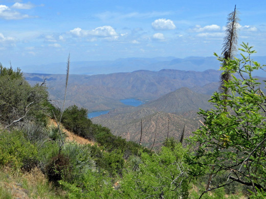
| Boulder Canyon #103 |
7.3 | 600 | From Canyon Lake Marina, this trail climbs above La Barge Creek for 2 miles and descends into the Boulder Creek drainage, which is followed southwards to the point it splits into east and west forks, below Palomino Mountain, where the path joins trail 104. A short distance further is the start of the Peralta Trail, and the three paths can be combined for a cross-mountain hike of around 14 miles. |
| Dutchman's #104 |
18 | 1,000 | This is the main trans-mountain route in the western Superstitions, and links with most other paths in the area so allowing for many different loop hikes. The southern end is at the Peralta Road trailhead, from where the path zig zags through the hills, right beneath Weaver's Needle then over more ravines and ridges, through 2,640 foot Parker Pass and down towards road FR 78. |
| Peter's #105 |
7 | 700 | Peter's Trail is a lesser used route between the end of FR 213 (the Tortilla Trailhead), along canyons and across mesas south of Tortilla Mountain, to a junction with trail #104. Starting from AZ 88 adds another 2.5 miles to the hike. |
| JF Ranch Trail #106 |
10 | 1,300 | The JF Ranch Trail leads southeast through the center of the Superstition Wilderness, starting in the north at the end of road FR 213, a 4WD route branching off the Apache Trail. The trail ends at another, longer 4WD track (FR 172), from Queen Valley. |
| Red Tanks #107 |
9 | 1,000 | Trail #107 follows the upper end of La Barge Canyon eastwards into a section of narrows, over higher ground and down Red Tanks Canyon to a junction with TR 108 (Coffee Flat Trail). The west end is at an intersection with the Dutchman's Trail, 2 miles east of Weaver's Needle. |
| Hoolie Bacon #111 |
4 | 700 | A connecting path between the end of FR 213 (Tortilla Trailhead) and TR 107, the Hoolie Bacon Trail is a lesser-used route across undulating ground in the heart of the Superstition Wilderness. |
| Bull Pass #129 |
1.6 | 470 | On the north side of Black Top Mesa, the Bull Pass Trail provides a short cut linking two points along TR #104, between East Boulder Canyon and Needle Canyon. |
| Terrapin #234 |
2.9 | 800 | The north end of the rather steep Terrapin Trail is at a junction with TR #104, from where the path climbs alongside Needle Canyon past the east side of Weaver's Needle, over a saddle and down to the Bluff Spring Trail. |
| Bluff Spring #235 |
3.4 | 800 | For most of its 3.4 miles the Bluff Spring Trail runs along rocky canyons near the south edge of the mountains. It starts at the Peralta Trailhead and ends at an intersection with trail #104, allowing for one possible loop hike of 8 miles. |
| Second Water #236 |
3.3 | 500 | This well traveled path forms the western half of a route between the First Water and Canyon Lake trailheads, passing a narrow ravine, flat grasslands (Garden Valley) and open slopes above Boulder Canyon. |
| Cavalry #239 |
3.2 | 370 | From TR #103, the Cavalry Trail climbs a ridge east of Boulder Canyon and enters the wide, rather overgrown valley of upper La Barge Canyon, which is followed southwards to a junction with TR #104. |
| Black Mesa #241 |
3 | 480 | Trail 241 crosses the middle of the steep sided, flat-topped Black Mesa, starting in the north near the First Water Trailhead and terminating at a junction with the Dutchman's Trail. |
Superstition Mountains - Featured Trails

Apache Trail Canyon
★★★★★
★★★★★
0.5 miles, 200 feet
Minor drainage beside the Apache Trail, enclosed for nearly a mile and forming a short, shallow slot canyon, containing pools and dryfalls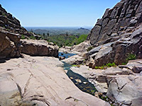
Hieroglyphic Trail
★★★★★
★★★★★
1.5 miles, 650 feet
One of the most accessible hikes in the mountains - short path climbing gently across a cactus-covered hillside close to a rocky dry wash, ending at some seasonal pools, beside which are many ancient petroglyphs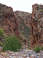
La Barge Canyon and the Boulder Canyon Trail
★★★★★
★★★★★
2.5 miles, 500 feet
Varied route that climbs steadily giving good views of Canyon Lake and the surrounding mountains then descends into a deep drainage (La Barge Canyon), which can be followed south further into the hills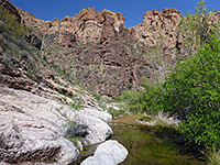
Lower Fish Creek
★★★★★
★★★★★
5.5 miles, 500 feet, or less
Stream flowing through a deep, winding canyon; explorable by off-trail hiking, past abundant and varied vegetation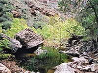
Upper Fish Creek
★★★★★
★★★★★
1.5 miles, 270 feet
Off trail hike along a scenic canyon which holds a permanent stream, forming pretty pools and small cascadesSuperstition Mountains - Nearby Places
- Fish Creek - watery canyon in the east Superstition Wilderness
- Lost Dutchman State Park - easily accessed Sonoran Desert landscapes
- Theodore Roosevelt Lake - artificial lake along Tonto Creek
Superstition Mountains - Similar Places
- Kofa Wildlife Refuge, Arizona - desert region with a distinct sense of isolation
- Picacho Peak State Park, Arizona - volcanic mountain alongside I-10
- Sonoran Desert National Monument, Arizona - rugged saguaro wilderness
All Contents © Copyright The American Southwest | Comments and Questions | Contribute | Affiliate Marketing Disclosure | Site Map