Contents: the hiking list below is divided into three regions:
- Red Rock Secret Mountain Wilderness, north of Sedona
- Munds Mountain Wilderness, east of Sedona
- Sedona and the Village of Oak Creek, the area closest to town

Sedona Trails - Red Rock Secret Mountain Wilderness (north of Sedona)
AB Young Trail #100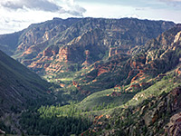 Length 2.5 miles (4 km) Elevation change 2000 feet (610 meters) Trailhead Bootlegger day use parking area Rating (1-5) ★★★★★ This short but very steep trail ascends the west side of Oak Creek Canyon, leading to the East Pocket Knob look-out tower on a wooded plateau at 7,200 feet, a site which may also be accessed from the top of the plateau by a long drive on forest road 231. Excellent views down the canyon and across to Verde Valley. |
Bear Mountain Trail #54 Length 2.4 miles (3.9 km) Elevation change 1800 feet (549 meters) Trailhead Along Boynton Pass Road Rating (1-5) ★★★★★ The relatively short but quite challenging hike to the top of Bear Mountain is one of many paths reached along Dry Creek Road (FR 152) and later Boynton Pass Road, starting from AZ 89A 3.2 miles west of the AZ 179 junction. The narrow, steep, sometimes rocky trail climbs up the side of the mountain and has ever improving, panoramic views, especially to the south. |
|
Bear Sign Trail Length 2.2 miles (3.5 km) Elevation change 400 feet (122 meters) Trailhead End of Dry Creek Road Rating (1-5) ★★★★★ Bear Sign Canyon is one of the more remote places near Sedona, and there really is a good chance of spotting traces of black bear activity, or even the animals themselves. The trailhead is at the end of the unpaved portion of Dry Creek Road, and the increasingly narrow canyon can be followed for some distance beyond the end of the official trail. |
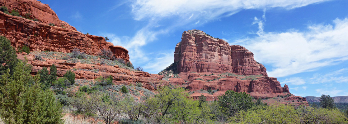
Birthing Cave Length 0.9 miles (1.4 km) Elevation change 250 feet (76 meters) Trailhead Parking area for Long Canyon, shortly before Seven Canyons Golf Club Rating (1-5) ★★★★★ Photogenic alcove in the Schnebly Hill sandstone at the edge of Mescal Mountain, reached by a path across level, bushy terrain, followed by a short, steep ascent. |
Boynton Canyon Trail #47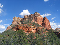 Length 3 miles (4.8 km) Elevation change 500 feet (152 meters) Trailhead Boynton Pass Road, shortly before Enchantment Resort Rating (1-5) ★★★★★ The hike along red walled Boynton Canyon is very popular - it is easily reached by the paved Dry Creek Road, and has no difficult spots or steep climbs apart from a short uphill section at the very end, to a viewpoint with high red cliffs on three sides. The main path is 3 miles long, but the canyon has several branches and all day could be spent exploring it. |
Brins Mesa Trail #119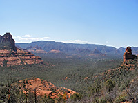 Length 3.8 miles (6.1 km) Elevation change 600 feet (183 meters) Trailhead Parking area at the end of Jordan Road Rating (1-5) ★★★★★ This easy trail climbs up a shallow canyon to the flat-topped Brins Mesa, a spur of Wilson Mountain, then continues down the far side. All of the trail has expansive views in most directions. It has two trailheads - south access is at the end of Jordan Road, starting from Highway 89A just north of the AZ 179 junction, while the north access is 3 miles along the unpaved section of Dry Creek Road. |
Cookstove Trail #143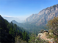 Length 0.7 miles (1.1 km) Elevation change 800 feet (244 meters) Trailhead Pine Flat campground Rating (1-5) ★★★★★ The Cookstove Trail is the shortest of four routes to the east rim of Oak Creek Canyon, near its northern end. It starts from Pine Flat Campground, ascending through mixed woodland to a viewpoint on a basalt outcrop. Forms a 2.6 mile loop with the Harding Springs Trail. |
Devils Bridge Trail #120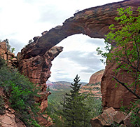 Length 1.9 miles (3.1 km) Elevation change 300 feet (91 meters) Trailhead Lower end of Dry Creek Road (FR 252). 4WD vehicles can drive 1.1 miles further Rating (1-5) ★★★★★ The bridge is actually a large natural arch in the red Supai sandstone cliffs on the north side of Capitol Butte, and reached by a short hike from Dry Creek Road (FR 152). The best views are obtained from the top of the bridge, which overlooks a large area of canyons and mesas in the Red Rock Secret Mountain Wilderness. |
Doe Mountain Trail #60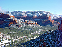 Length .7 miles (1.1 km) Elevation change 400 feet (122 meters) Trailhead Along Boynton Pass Road Rating (1-5) ★★★★★ Doe Mountain is an isolated, 450 foot high mesa with a perfectly flat top. The trailhead is the same as for the Bear Mountain Trail, and although the path ascends quickly to the summit in less than a mile, it is worth walking all around the edge (about another mile), to see views in all directions, including higher mountains in the north, Capitol Butte and downtown Sedona to the south, and the Verde Valley to the west. |
|
Dry Creek Trail #52 Length 2.7 miles (4.3 km) Elevation change 700 feet (213 meters) Trailhead End of Dry Creek Road Rating (1-5) ★★★★★ A gentle walk along a narrow, wooded, increasingly steep red rock canyon with sandstone ledges and cliffs, this starts right at the north end of the Dry Creek approach road, so receives fewer visitors than other trails closer to Sedona. |
Fay Canyon Trail #53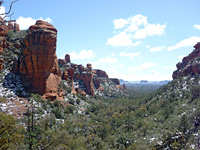 Length 1 miles (1.6 km) Elevation change 250 feet (76 meters) Trailhead Along Boynton Pass Road Rating (1-5) ★★★★★ Fay is a short red rock box canyon containing a natural arch, a seasonal stream, and a collection of desert plants typical of the lower elevations around Sedona. The trailhead is along Dry Creek Road then Boynton Pass Road. |
Harding Springs Trail #51 Length 0.7 miles (1.1 km) Elevation change 700 feet (213 meters) Trailhead Verge at the entrance to the Cave Spring campground Rating (1-5) ★★★★★ This short path is the easiest of four routes to the east rim of upper Oak Creek Canyon, climbing steadily through conifer woodland to edge of a volcanic plateau. It forms a 2.6 mile loop with the Cookstove Trail. Good views from the top, and an interesting variety of plant species. |
|
HS Canyon #50 Length 1.6 miles (2.6 km) Elevation change 300 feet (91 meters) Trailhead 3.4 miles along the unpaved section of Dry Creek Road Rating (1-5) ★★★★★ HS is a typical Sedona canyon - moderately narrow, forested at lower levels but with sheer red cliffs higher up. The short trail to it extends about half way along, and begins 0.6 miles along the path to Secret Canyon. |
Long Canyon #122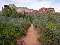 Length 3.7 miles (6 km) including an unmaintained section at the end Elevation change 1000 feet (305 meters) Trailhead Long Canyon Road, off FR 152 Rating (1-5) ★★★★★ Long Canyon is a large and increasingly overgrown drainage enclosed by high red and brown cliffs, southeast of Secret Mountain. Not often explored, especially the upper end where the trail steepens, climbing up to a viewpoint above the woodland |
|
Loy Canyon #5 Length 4.8 miles (7.7 km) Elevation change 2000 feet (610 meters) Trailhead Towards the end of Loy Butte Road Rating (1-5) ★★★★★ Loy Canyon is 14 miles west of Sedona on FR 152 and then the unpaved Loy Butte Road, in a remote and little visited area. The lower reaches are very wide and level but the drainage narrows sharply at the upper end, where the trail ascends steeply to a forested ridge at 6,500 feet, on the other side of which is the upper part of Secret Canyon. |
North Wilson Trail #123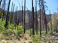 Length 2.1 miles (3.4 km) Elevation change 1800 feet (549 meters) Trailhead Along US 89A at the Encinoso picnic area Rating (1-5) ★★★★★ Starting at the Encinoso picnic area on AZ 89A, 2 miles north of Sedona, the North Wilson Trail climbs half way up Wilson Mountain where it links with another trail that leads to the summit, 2 miles further. Not many trails ascend the walls of Oak Creek Canyon, so this is a popular route, despite its strenuous nature. |
Secret Canyon Trail #121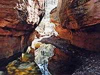 Length 4.4 miles (7.1 km) Elevation change 800 feet (244 meters) Trailhead 3.4 miles along the unpaved section of Dry Creek Road Rating (1-5) ★★★★★ Rewarding hike along one of Sedona's longer canyons, the upper stretches of which are wooded, quite enclosed, and contain a permanent stream flowing through pools, cascades and short narrows sections. Continuation hikes are possible further up the canyon, beyond the end of the official trail |
|
Secret Mountain #109 Length 5 miles (8 km) Elevation change level overall Trailhead End of a rough track, 21 miles from US 89A; also accessible via the Loy Canyon Trail Rating (1-5) ★★★★★ This trail winds along the south edge of Secret Mountain, past the tops of several deep canyons including Hart Well, Boynton and Long, and ends at a small summit at 6,607 feet. The starting point is the ridge at the end of Loy Canyon Trail, so the total (one-way) distance is 10 miles, and this is a trip more suitable for backpacking. The views along the path are about the most spectacular anywhere in Sedona. |
Soldier Pass Trail #66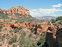 Length 2 miles (3.2 km) Elevation change 450 feet (137 meters) Trailhead Parking area at the end of Soldier Pass Road Rating (1-5) ★★★★★ An easy route up to Brins Mesa via the wooded canyon of Soldier Creek, this path enters the wilderness area near the end, and links with the Brins Mesa Trail. |
Sterling Pass Trail #46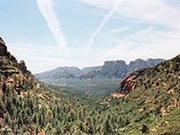 Length 2.4 miles (3.9 km) Elevation change 1100 feet (335 meters) Trailhead Along US 89A near Slide Rock Lodge Rating (1-5) ★★★★★ The Sterling Pass route leads steeply up the side of Oak Creek Canyon and over a ridge into the upper end of Sterling Canyon, then descends this ravine as far as an overlook of Vultee Arch. From here, the Vultee Arch Trail continues downstream, linking with FR 152. |
|
Telephone Trail #72 Length 1.2 miles (1.9 km) Elevation change 1000 feet (305 meters) Trailhead Verge along Hwy 89A, 0.6 miles south of Cave Springs Campground Rating (1-5) ★★★★★ Named for a nearby telephone line, this short, steep path climbs to the east rim of Oak Creek Canyon, though a mix of thick woodland and more open areas. |
Thomas Point Trail #142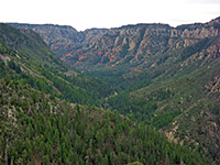 Length 1 miles (1.6 km) Elevation change 900 feet (274 meters) Trailhead Call of the Canyon parking area, beside US 89A Rating (1-5) ★★★★★ This short but steep path climbs the east side of Oak Creek Canyon, initially through pine forest then mostly across open, bushy sandstone slopes with good views up and down the ravine, ending in wooded surrounds once more, on the rim. |
Vultee Arch Trail #22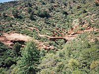 Length 1.6 miles (2.6 km) Elevation change 400 feet (122 meters) Trailhead At the end of the unpaved Dry Creek Road Rating (1-5) ★★★★★ An easy hike, climbing gently along Sterling Canyon to a viewpoint of a large, graceful sandstone arch, on the far side of a forested ravine - starting from the north end of Dry Creek Road (FR 152). |
West Fork of Oak Creek #108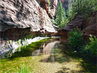 Length 3.1 miles (5 km) Elevation change 160 feet (49 meters) Trailhead Call of the Canyon parking area, beside US 89A Rating (1-5) ★★★★★ Perhaps the best hike in the Sedona area, along a deep, narrow, forested canyon with a permanent stream bordered by dramatic red rocks. The canyon is explorable for many miles beyond the end of the official trail, where wading and even swimming are required in a few places. |
Wilson Canyon Trail #49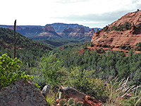 Length 1.2 miles (1.9 km) Elevation change 300 feet (91 meters) Trailhead Beside Midgely Bridge, along US 89A Rating (1-5) ★★★★★ Popular route into a box canyon; alongside a wooded streamway, past occasional, seasonal pools and small cascades, then up above the trees to a grand viewpoint enclosed by red and white cliffs on three sides. |
Wilson Mountain Trail #10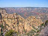 Length 4.5 miles (7.2 km) Elevation change 2450 feet (747 meters) Trailhead Beside Midgely Bridge, along US 89A Rating (1-5) ★★★★★ This is the most strenuous trail in the Sedona area, and with the highest elevation gain, but of course the views at the top of the mountain are excellent. The first 2 miles of the trail is steepest - the remainder is mostly level, as it follows the flat top of Wilson Mountain northwards, ending at a promontory overlooking Sterling Canyon. Starting point is near Midgely Bridge, 2 miles north of the AZ 89A/AZ 179 junction. |
Sedona Trails - Munds Mountain Wilderness (East of Sedona)
|
Hot Loop #94 Length 8 miles (12.9 km) Elevation change 2300 feet (701 meters) Trailhead Along US 89A south of Oak Creek Rating (1-5) ★★★★★ Hot Loop (a one-way path) starts alongside Dry Beaver Creek, which crosses under AZ 179 two miles south of the village of Oak Creek. The trail soon climbs steeply to a plateau, followed by a long, mostly level walk along Horse Mesa, high above Woods Canyon, and ending with another climb to the main plateau at Jacks Point Tank. Connecting paths at the start and finish (main one is Jacks Canyon Trail) allow for a long loop hike. |
|
Jacks Canyon #55 Length 6.6 miles (10.6 km) Elevation change 2000 feet (610 meters) Trailhead Short dirt track along Jacks Canyon Road Rating (1-5) ★★★★★ A long hike beside the bushy streamway in Jacks Canyon, between Munds Mountain and Horse Mesa, ending with a steep ascent up the side of the Schnebly Hill plateau, which offers panoramic views over the surrounding landscape. Start point for the hike is 3 miles along Jacks Canyon Road, which forks off AZ 179 in the middle of Oak Creek village. |
Margs Draw Trail #163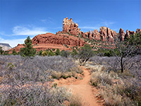 Length 2 miles (3.2 km) Elevation change 200 feet (61 meters) Trailhead Parking area along Schnebly Hill Road; also accessible from Morgan Road Rating (1-5) ★★★★★ Lesser-used route at the foot of the dramatic red cliffs of Munds Mountain, on the east side of Sedona, crossing sandy flats, patches of trees and several minor drainages; links Schnebly Hill Road with Morgan Road |
|
Munds Mountain #77 Length 2.5 miles (4 km) Elevation change 500 feet (152 meters) Trailhead End of a rough track on Schnebly Hill, also reachable via the 8 mile Jacks Canyon Trail Rating (1-5) ★★★★★ Beginning at the north end of the Jacks Canyon Trail, this path climbs further to the summit of Munds Mountain at 6,834 feet, then follows the ridge a little way to the south. The scenery hereabouts is a little less spectacular than places to the north; the landscape is more vegetated, and the rocks are mostly white rather than red. |
|
Schnebly Hill #158 Length 1.7 miles (2.7 km) Elevation change 400 feet (122 meters) Trailhead Schnebly Hill Road Rating (1-5) ★★★★★ An old roadbed provides a course for this initially steep trail, heading south from Schnebly Hill Road near the upper end of its climb from Oak Creek valley. The path reaches the edge of a grassy plateau and follows this south to intersections with the Munds Mountain and Hot Loop trails. |
Woods Canyon Trail #93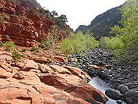 Length 4.9 miles (7.9 km) to the big pool Elevation change 450 feet (137 meters) Trailhead Red Rock Ranger Station, along Hwy 179 Rating (1-5) ★★★★★ Easy but relatively long walk up a low elevation canyon containing permanent pools and red rock outcrops - in the Munds Mountain Wilderness south of Sedona. The canyon can be followed beyond the official trail; up to 6 miles further. There are plenty of wildflowers in the canyon, reflecting the varied habitats of meadows, sandy flats, mixed woodland and riparian. |
Sedona Trails - Routes close to Sedona and Village of Oak Creek
Airport Loop #211 Length 3.2 miles (6.9 km) Elevation change 150 feet (46 meters) Trailhead Airport Road Rating (1-5) ★★★★★ Including the short Table Top Trail (#212), this mostly shadeless loop path is just over 4 miles in length, circling the flat summit of Table Top Mountain, site of Sedona Airport. |
Allens Bend Trail #111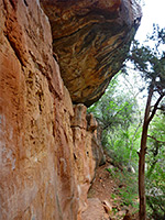 Length 0.5 miles (0.8 km) Elevation change level Trailhead Grasshopper Point picnic area Rating (1-5) ★★★★★ This is one of the few trails right beside Oak Creek, a short path that links the Grasshopper Point picnic area (2 miles north of Sedona on AZ 89A) with the trailhead for Casner Canyon, passing by nice red rocks of the Supai formation on one side and the fast flowing waters of the creek close by on the other, though mostly obscured by trees. |
|
Bell Rock Pathway Length 3.7 miles (6 km) Elevation change 180 feet (55 meters) Trailhead Little Horse Trailhead; also accessible from several other places Rating (1-5) ★★★★★ The popular Bell Rock Pathway follows close to Hwy 179 (east side) for 3.5 miles, starting in the north at the Little Horse trailhead, passing beneath Bell Rock and ending at Courthouse Vista, at the north edge of Vilage of Oak Creek. |
Broken Arrow Trail #125 Length 1.5 miles (2.4 km) Elevation change 300 feet (91 meters) Trailhead Parking area at the end of Morgan Road Rating (1-5) ★★★★★ The Broken Arrow Trail offers a quick route into red rock landscape, starting at the end of Morgan Road, which meets AZ 179 one mile south of the AZ 89A junction. The path is easy and well used, and climbs gradually to a slickrock pass between two high buttes (Chicken Point), giving good, elevated views over the surroundings. The Little Horse trail continues from here, providing an alternative route back to the highway. |
Casner Canyon Trail #11 Length 2.6 miles (4.2 km) Elevation change 1500 feet (457 meters) Trailhead Small pullout along US 89A; more space a short distance south at Grasshopper Point. Also accessed along the Schnebly Hill Road Rating (1-5) ★★★★★ There are only three trails on the east side of Oak Creek Canyon, where the cliffs are more sheer than on the west side - one is along Casner Canyon, at first following close to the streambed then climbing steadily up the side of the ravine, right to the forested plateau. A short walk through the woodland reaches the Schnebly Hill Road. There is limited parking at the trailhead, or more space at Grasshopper Point picnic area, which is linked to Casner Canyon by the Allen's Bend trail. |
Cathedral Rock Trail #170 Length .7 miles (1.1 km) Elevation change 600 feet (183 meters) Trailhead Parking area along Back of Beyond Road Rating (1-5) ★★★★★ This short hike leads to the base of one of Sedona's most famous red rock buttes, starting from the Back of Beyond Road on the west side of AZ 179, 3.4 miles south of the AZ 89A junction. The popular path climbs a steep slickrock hillside and has spectacular views all around. |
Courthouse Butte Trail #135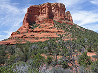 Length 3.4 miles (5.5 km) loop Elevation change 200 feet (61 meters) Trailhead North Bell Rock parking area, along Hwy 179 Rating (1-5) ★★★★★ Loop around the famous Sedona landmarks of Bell Rock and Courthouse Butte. The rock is very busy but not so many people walk all around the butte, along a sometimes rocky path that gives ever-changing views of the red rock surroundings, and in spring encounters many wildflower species. |
Crescent Moon Ranch
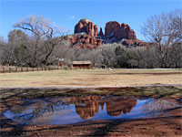 Length 0.5 miles (0.8 km) Elevation change level Trailhead Day use parking, off Red Rock Crossing Road Rating (1-5) ★★★★★ Easy path beside Oak Creek, across meadows and through cottonwood groves, past red rocks, old buildings, and reflective pools, plus views of Cathedral Rock. |
|
Girdner Trail #162 Length 4.5 miles (7.2 km) Elevation change 360 feet (110 meters) Trailhead Cultural Park Place; also accessed from Dry Creek Road Rating (1-5) ★★★★★ This path follows part of the lower canyon of Dry Creek, west of Sedona, in places quite narrow and shady. The southernmost section climbs above the drainage and traverses an open plateau. The route is accessed from the north along Dry Creek Road, from the south just off US89A. |
|
Huckaby Trail #161 Length 2.6 miles (4.2 km) Elevation change 250 feet (76 meters) Trailhead Large parking area near the lower end of Schnebly Hill Road Rating (1-5) ★★★★★ The varied scenery along the Huckabee Trail includes the wooded corridor of Oak Creek, an elevated ridge with good views, and the narrower drainage of Bear Wallow Canyon. The path runs between Midgely Bridge picnic area and the lower end of Schnebly Hill Road. |
|
Jim Thompson Trail #124 Length 3 miles (4.8 km) Elevation change 150 feet (46 meters) Trailhead End of Jordan Road; also accessible from Midgley Bridge Rating (1-5) ★★★★★ The Jim Thompson Trail is a connecting route between the Midgely Bridge (Wilson Canyon) and Jordan Road trailheads, crossing undulating, lightly wooded land of ridges and drainages. |
Little Horse Trail Length 1.5 miles (2.4 km) Elevation change 300 feet (91 meters) Trailhead Along US 89A on the south edge of Sedona Rating (1-5) ★★★★★ A gentle route leading through open land towards high red buttes, this trail begins beside AZ 179, 3.6 miles south of the AZ 89A junction, and ends at Chicken Point, where the Broken Arrow trail continues northwards. |
Munds Canyon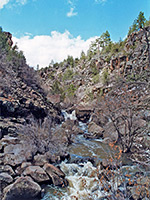 Length 2 miles (3.2 km) or more Elevation change 500 feet (152 meters) Trailhead West side of I-17, exit 322 Rating (1-5) ★★★★★ Off trail route across a forested plateau and into a boulder-filled, basalt-walled gorge containing a permanent stream. The full length of the canyon is 6 miles but just the upper few miles make a (relatively) good short hike. The lower end of the gorge contains some private land. |
Schuerman Mountain Trail #2356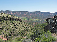 Length 2.2 miles (3.5 km) between the trailheads Elevation change 360 feet (110 meters) Trailhead Parking area just off Red Rock Loop Rating (1-5) ★★★★★ At 4,899 feet, Scheurman Mountain is one of Sedona's lesser summits but the short trail to the top still gives nice views over the town, and the Oak Creek valley in Red Rock State Park to the south. The trailhead is along the top part of the Red Rock Loop road, and this meets AZ 89A 4 miles west of the junction with AZ 179. A longer trail continues past the summit and joins the south part of the loop road. |
All Contents © Copyright The American Southwest | Comments and Questions | Contribute | Affiliate Marketing Disclosure | Site Map