Vultee Arch and Sterling Pass Trails, Sedona
Arizona > Sedona > Hiking > Vultee Arch/Sterling Pass Trails
Vultee Arch and Sterling Pass Trails
#22, #46
#22, #46
Two trails that meet at a viewpoint of a graceful sandstone arch, on the far side of a forested canyon. Vultee Arch Trail climbs gently along the canyon, starting at the end of a 4 mile unpaved road that can sometimes have a few rough spots, while the more strenuous Sterling Pass Trail climbs steeply to a saddle then descends a little into the upper end of the canyon
Length: 1.6/2.4 miles
Elevation change: 400/1,100 feet
Difficulty: Easy/moderate
Type: One-way trails that meet at a viewpoint of Vultee Arch
Usage: Medium/low
Season: All year, but Sedona is hot in summer, and in winter & spring Dry Creek Road is sometimes closed when affected by snow
Trailhead: Sterling Pass: along US 89A near Slide Rock Lodge. Vultee Arch: at the end of the unpaved Dry Creek Road
Rating (1-5): ★★★★★

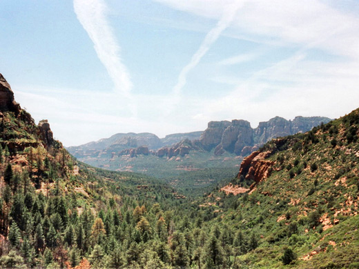
There is no shortage of hiking paths through the extensive red rock country around Sedona, and they provide a relaxing leisure alternative to the abundance of art galleries, crystal shops and vortex advisors in town. Most trails are within the Red Rock Secret Mountain Wilderness - a 6 mile paved road (FR 152) leads from the west edge of Sedona close to this scenic area of red cliffs and twisting valleys, then unpaved tracks and foot trails continue into the back country.
One easy half day walk is to Vultee Arch, a large eroded cavity in sandstone cliffs at the side of a wooded canyon north of Sedona and reached from town by the 1.6 mile Vultee Arch Trail; however a more interesting journey involves an approach from the east starting from US 89 in Oak Creek Canyon, and hiking over Sterling Pass at 5,700 feet.
Vultee Arch and Sterling Pass topographic map.
Sedona location map.
12 views of the Vultee Arch and Sterling Pass trails.
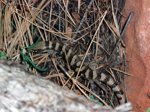
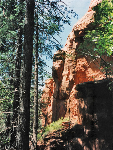
The start of the route to Vultee Arch is not obvious, but it is marked by a rusty sign near milepost 380, a short distance south of Slide Rocks State Park - a walk along the busy road is necessary as the closest parking is a few hundred meters away. At first, the path climbs sharply through dense woodland, then the land becomes more open as the route follows the course of a dry streambed. Elevation gain is still steady and steep, especially after 1.5 miles when many switchbacks mark the ascent up to Sterling Pass - all around are reddish cliffs with large and small eroded formations. The area has many pretty wildflowers in spring and early summer such as skyrocket, Canada violet, blue larkspur and red echinocereus cacti. Wildlife is also plentiful - there are colorful butterflies, squirrels and lizards - principally the banded Arizona alligator lizard and several species of iguanidae (tree lizards).
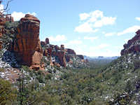
At the summit (Sterling Pass), the path winds through a fairly narrow gap between two cliffs, then zig-zags down the other side - this is slightly steeper, with more switchbacks and not as many rock formations. After a 20 minute descent, the valley opens out and the land becomes quite flat, with pinkish-flowered meadows at either side, and a small stream begins to flow. The setting is most tranquil and peaceful.
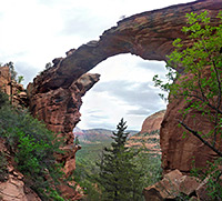
Trail crosses stream a few times, and soon a side-path branches off and leads 150 meters to an open rocky area with a good view of Vultee Arch. There is a plaque recording a plane crash which killed Mr. Vultee and wife, aircraft pioneers in the 1930s, after whom the formation was named. The arch is interesting, but not as spectacular as many of those in Arches National Park, in Utah. It takes a further 20 minutes to hike directly underneath, while the main path (the Vultee Arch Trail) continues down the valley 1.7 miles to FR 152, Dry Creek Road, which is also used to reach Secret Canyon. The round trip to this point requires about 4 hours of brisk hiking, and is memorable for dramatic red cliffs, many colorful wildflowers and cacti, the curious shapes of eroded rock formations, and the solitude. Most of the route is shaded and therefore cool and sheltered in the hot days of summer.
One easy half day walk is to Vultee Arch, a large eroded cavity in sandstone cliffs at the side of a wooded canyon north of Sedona and reached from town by the 1.6 mile Vultee Arch Trail; however a more interesting journey involves an approach from the east starting from US 89 in Oak Creek Canyon, and hiking over Sterling Pass at 5,700 feet.
Maps
Vultee Arch and Sterling Pass topographic map.
Sedona location map.
Photographs
12 views of the Vultee Arch and Sterling Pass trails.
Start of the Sterling Pass Trail
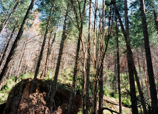
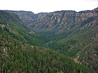
The start of the route to Vultee Arch is not obvious, but it is marked by a rusty sign near milepost 380, a short distance south of Slide Rocks State Park - a walk along the busy road is necessary as the closest parking is a few hundred meters away. At first, the path climbs sharply through dense woodland, then the land becomes more open as the route follows the course of a dry streambed. Elevation gain is still steady and steep, especially after 1.5 miles when many switchbacks mark the ascent up to Sterling Pass - all around are reddish cliffs with large and small eroded formations. The area has many pretty wildflowers in spring and early summer such as skyrocket, Canada violet, blue larkspur and red echinocereus cacti. Wildlife is also plentiful - there are colorful butterflies, squirrels and lizards - principally the banded Arizona alligator lizard and several species of iguanidae (tree lizards).
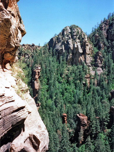
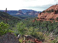
Sterling Pass
At the summit (Sterling Pass), the path winds through a fairly narrow gap between two cliffs, then zig-zags down the other side - this is slightly steeper, with more switchbacks and not as many rock formations. After a 20 minute descent, the valley opens out and the land becomes quite flat, with pinkish-flowered meadows at either side, and a small stream begins to flow. The setting is most tranquil and peaceful.
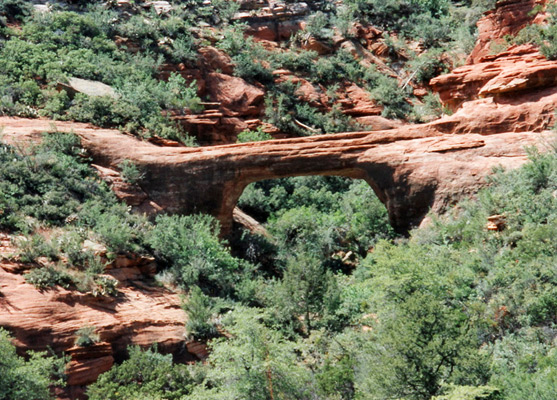
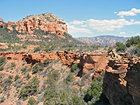
Vultee Arch
Trail crosses stream a few times, and soon a side-path branches off and leads 150 meters to an open rocky area with a good view of Vultee Arch. There is a plaque recording a plane crash which killed Mr. Vultee and wife, aircraft pioneers in the 1930s, after whom the formation was named. The arch is interesting, but not as spectacular as many of those in Arches National Park, in Utah. It takes a further 20 minutes to hike directly underneath, while the main path (the Vultee Arch Trail) continues down the valley 1.7 miles to FR 152, Dry Creek Road, which is also used to reach Secret Canyon. The round trip to this point requires about 4 hours of brisk hiking, and is memorable for dramatic red cliffs, many colorful wildflowers and cacti, the curious shapes of eroded rock formations, and the solitude. Most of the route is shaded and therefore cool and sheltered in the hot days of summer.
Vultee Arch and Sterling Pass - Similar Hikes
All Contents © Copyright The American Southwest | Comments and Questions | Contribute | Affiliate Marketing Disclosure | Site Map