West Fork of Oak Creek Trail
#108
#108
Perhaps the best hike in the Sedona area, along a deep, narrow, forested canyon with a permanent though usually relatively shallow stream bordered by dramatic red rocks, in places forming photogenic, subway-like channels. The canyon is also explorable for many miles beyond the end of the official trail, where wading is required in a few places
Length: 3.1 miles
Elevation change: 160 feet
Difficulty: Easy to moderate; 13 creek crossings
Type: One way
Usage: High for the official trail; low thereafter
Season: All year, except at times of peak snowmelt
Trailhead: Call of The Canyon parking area, beside US 89A
Rating (1-5): ★★★★★
Elevation change: 160 feet
Difficulty: Easy to moderate; 13 creek crossings
Type: One way
Usage: High for the official trail; low thereafter
Season: All year, except at times of peak snowmelt
Trailhead: Call of The Canyon parking area, beside US 89A
Rating (1-5): ★★★★★

The best trail in the Sedona area is along the lower end of the West Fork of Oak Creek, a permanent though relatively shallow stream that flows through a deep, forested canyon, quite narrow in places, with many pretty eroded rock formations and plentiful wildlife. The West Fork joins the main Oak Creek Canyon near its north end, about six miles south of the point where highway US 89A descends from the flattish, densely-forested volcanic plateau that extends south from Flagstaff into the red rock country around Sedona.
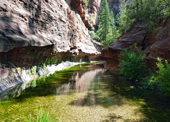
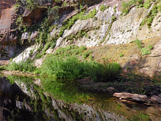
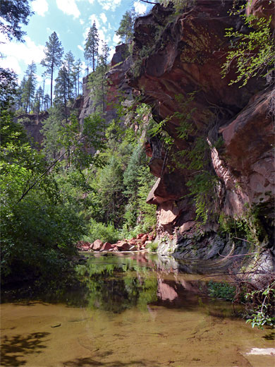
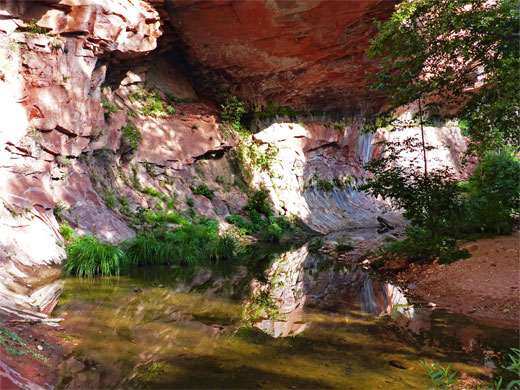
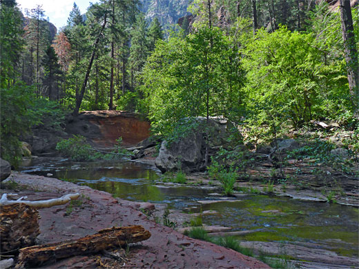
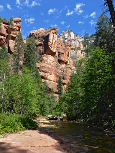
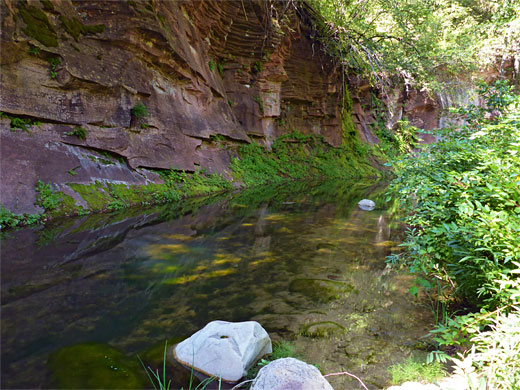
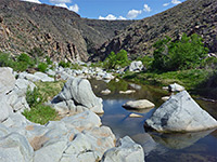
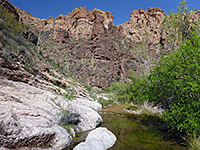
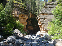
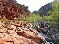
The exposed rocks around the creek in the lower reaches of the canyon are deep red in color, from the Hermit Formation and the Schnebly Hill Formation, while high above are yellow-brown or whitish layers of Coconino sandstone, Toroweap Formation and Kaibab limestone; these gradually come closer to the streambed as the drainage steadily gains height, until it rises above the red strata after about 4 miles. The rocks are thin-layered, often eroded into curving or jagged shapes, and around the creekbed forming frequent short, tunnel-like passages, similar to the famous Subway of Zion National Park.
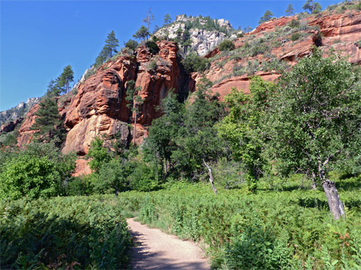
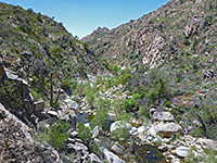
The canyon is many hundreds of feet deep and moderately narrow right from the start, wooded, overgrown and shaded with many fallen trees and old logs, often lying in the streamway. The path crosses the creek thirteen times and its course is not always obvious; in some places there are paths at both sides. Posts indicate the distance every half mile, though the 2.5 and 3.0 mile markers are not obvious. Wildlife is quite abundant, if not necessarily interesting - typical sights are butterflies, colorful birds, squirrels, lizards and snakes.
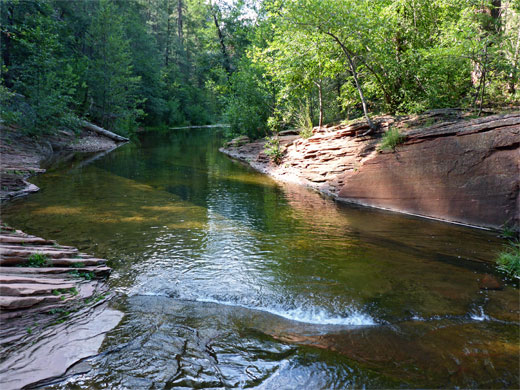
Occasionally the creek has pools three to four feet deep which harbor trout and other fish although usually the water (in summer) is only a few inches deep. The stream flows gently, and the hike is very pleasant and relaxing, and cool since only occasional sunlight reaches the canyon floor so the trip is ideal for the hot summer months. Fall brings rich colors to the leaves, while in winter the cliffs are framed with icicles, and the creek partially freezes.
West Fork of Oak Creek topographic map, Sedona location map.
21 views of the West Fork of Oak Creek.
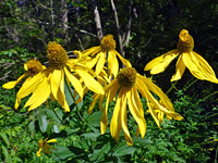
US 89A is narrow and winding with few places to park at the roadside so most visitors to the West Fork are obliged to pay $12 per vehicle (2024) to use an official carpark beside the trailhead, at the Call Of The Canyon day use area, between milesposts 384 and 385. This is set in a clearing next to a grassy meadow which in summer is filled with wildflowers of every color and frequented by humming birds and large butterflies - a most attractive sight. All places may be taken by mid morning at busy times of the year. Cheaper parking (just $5 for the Red Rock Pass) is possible on a couple of pull-outs along the main road. One other hike starts here; the little-used, one mile route to Thomas Point.
The West Fork Trail starts by crossing the fern- and wildflower-filled meadow south of the parking area then enters a narrow corridor of trees alongside Oak Creek, moving to the far side via a high footbridge and continuing through another field, next to an orchard, to the fragmentary ruins of Mayhew Lodge, a group of buildings dating from the early 20th century, operated as a guest retreat until 1968. A notice warns that the bridge may be closed during snowy periods in winter. Most of the lodge was destroyed by fire in 1980, leaving just a chimney stack and a few stone walls and floors from the main structures, though a chicken coop and a cave dwelling do survive intact, a little way north at the base of a cliff. A 1923 silent movie, Call of the Canyon, was partly filmed at the lodge, and its name lives on at the trailhead parking area. The lodge is situated right at the mouth of the West Fork canyon just north of the confluence; the path turns westwards, leaving the sunny meadow for the cool woodland around the creek, below cliffs over 1,000 feet tall.
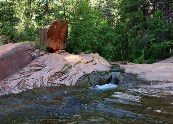
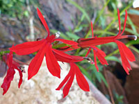
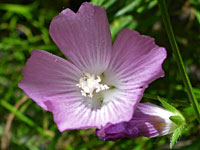
Below a bend along the creek is one of the many hanging gardens where riparian plants grow on the steeply sloping walls just above the creekbed; colorful wildflowers here include red cardinal and golden columbine. The first of the 13 creek crossings is just beyond, after which the trail runs alongside one of the subway-like passageways, soon followed by the second crossing, and continuing through a longer patch of lush woodland, carpeted with ferns. The third crossing is just before another subway channel with more substantial overhanging cliffs, while the fourth, back on the northeast side of the creek, leads to a patch of drier woods which contain a pair of minor tributaries, one usually dry, the other more likely to contain flowing water, originating from the slopes below Harding Point. The path days out-of-sight of the creek for a while, rounds a broad bend, crosses to the south and soon back to the north in the middle of a pretty section of the stream. The seventh crossing is not far beyond, next to a huge red boulder and a little cascade.
A longer wooded section of the trail, straight then curving round a protruding ridge, leads to the ninth crossing and then the tenth, after which a short flight of steps take the route up to red bench, and later across another little tributary. The 11th crossing is followed by a patch of darker woodland and then, after the final two fords in quick succession, the trail, now on the south side, rises rather higher above a narrow part of the creekbed and finally descends to a small pebble beach, just before the first place in the canyon where the water covers all of the floor, from wall to wall. The beach marks the end of the trail, and a notice warns continuation hikers that camping is not permitted until after another 2.7 miles. Ahead, a long pool between subway-like cliffs curves gradually out of sight, followed by many more miles of enchanting canyon - see route description.
The exposed rocks around the creek in the lower reaches of the canyon are deep red in color, from the Hermit Formation and the Schnebly Hill Formation, while high above are yellow-brown or whitish layers of Coconino sandstone, Toroweap Formation and Kaibab limestone; these gradually come closer to the streambed as the drainage steadily gains height, until it rises above the red strata after about 4 miles. The rocks are thin-layered, often eroded into curving or jagged shapes, and around the creekbed forming frequent short, tunnel-like passages, similar to the famous Subway of Zion National Park.
The canyon is many hundreds of feet deep and moderately narrow right from the start, wooded, overgrown and shaded with many fallen trees and old logs, often lying in the streamway. The path crosses the creek thirteen times and its course is not always obvious; in some places there are paths at both sides. Posts indicate the distance every half mile, though the 2.5 and 3.0 mile markers are not obvious. Wildlife is quite abundant, if not necessarily interesting - typical sights are butterflies, colorful birds, squirrels, lizards and snakes.
Occasionally the creek has pools three to four feet deep which harbor trout and other fish although usually the water (in summer) is only a few inches deep. The stream flows gently, and the hike is very pleasant and relaxing, and cool since only occasional sunlight reaches the canyon floor so the trip is ideal for the hot summer months. Fall brings rich colors to the leaves, while in winter the cliffs are framed with icicles, and the creek partially freezes.
Maps
West Fork of Oak Creek topographic map, Sedona location map.
Photographs
21 views of the West Fork of Oak Creek.
Parking
US 89A is narrow and winding with few places to park at the roadside so most visitors to the West Fork are obliged to pay $12 per vehicle (2024) to use an official carpark beside the trailhead, at the Call Of The Canyon day use area, between milesposts 384 and 385. This is set in a clearing next to a grassy meadow which in summer is filled with wildflowers of every color and frequented by humming birds and large butterflies - a most attractive sight. All places may be taken by mid morning at busy times of the year. Cheaper parking (just $5 for the Red Rock Pass) is possible on a couple of pull-outs along the main road. One other hike starts here; the little-used, one mile route to Thomas Point.
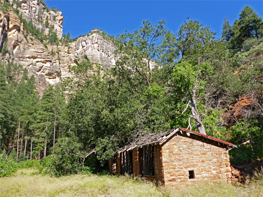
Mayhew Lodge
The West Fork Trail starts by crossing the fern- and wildflower-filled meadow south of the parking area then enters a narrow corridor of trees alongside Oak Creek, moving to the far side via a high footbridge and continuing through another field, next to an orchard, to the fragmentary ruins of Mayhew Lodge, a group of buildings dating from the early 20th century, operated as a guest retreat until 1968. A notice warns that the bridge may be closed during snowy periods in winter. Most of the lodge was destroyed by fire in 1980, leaving just a chimney stack and a few stone walls and floors from the main structures, though a chicken coop and a cave dwelling do survive intact, a little way north at the base of a cliff. A 1923 silent movie, Call of the Canyon, was partly filmed at the lodge, and its name lives on at the trailhead parking area. The lodge is situated right at the mouth of the West Fork canyon just north of the confluence; the path turns westwards, leaving the sunny meadow for the cool woodland around the creek, below cliffs over 1,000 feet tall.
Oak Creek Canyon
Below a bend along the creek is one of the many hanging gardens where riparian plants grow on the steeply sloping walls just above the creekbed; colorful wildflowers here include red cardinal and golden columbine. The first of the 13 creek crossings is just beyond, after which the trail runs alongside one of the subway-like passageways, soon followed by the second crossing, and continuing through a longer patch of lush woodland, carpeted with ferns. The third crossing is just before another subway channel with more substantial overhanging cliffs, while the fourth, back on the northeast side of the creek, leads to a patch of drier woods which contain a pair of minor tributaries, one usually dry, the other more likely to contain flowing water, originating from the slopes below Harding Point. The path days out-of-sight of the creek for a while, rounds a broad bend, crosses to the south and soon back to the north in the middle of a pretty section of the stream. The seventh crossing is not far beyond, next to a huge red boulder and a little cascade.
End of the West Fork Trail
A longer wooded section of the trail, straight then curving round a protruding ridge, leads to the ninth crossing and then the tenth, after which a short flight of steps take the route up to red bench, and later across another little tributary. The 11th crossing is followed by a patch of darker woodland and then, after the final two fords in quick succession, the trail, now on the south side, rises rather higher above a narrow part of the creekbed and finally descends to a small pebble beach, just before the first place in the canyon where the water covers all of the floor, from wall to wall. The beach marks the end of the trail, and a notice warns continuation hikers that camping is not permitted until after another 2.7 miles. Ahead, a long pool between subway-like cliffs curves gradually out of sight, followed by many more miles of enchanting canyon - see route description.

West Fork of Oak Creek - Similar Hikes
All Contents © Copyright The American Southwest | Comments and Questions | Contribute | Affiliate Marketing Disclosure | Site Map