Grand Canyon National Park - South Rim Trails
Arizona > Grand Canyon National Park > South Rim > Hiking
Of the rim to river routes, by far the most popular are the Bright Angel and South Kaibab trails, both leading eventually to Phantom Ranch, where hikers may, if reserving up to a year in advance, stay for one or more nights by the Colorado. Next in order of difficulty are the Tanner and Grandview trails, both fairly well used; all the other paths to the river are unmaintained and for experienced hikers only.
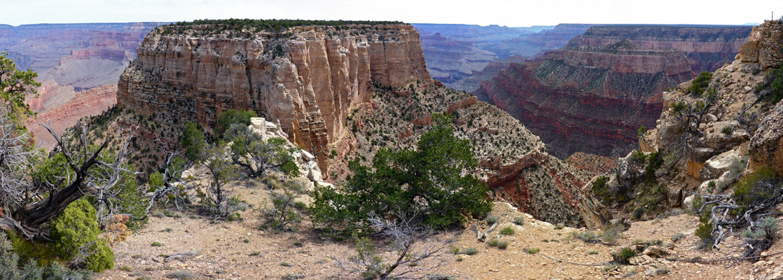
The Grand Canyon National Park map indicates the location of the central trails. Countdown of the top 20 trails.

Grand Canyon Trails - South Rim
|
Beamer Trail Length 10 miles (16.1 km) Elevation change 130 feet (40 meters) Trailhead At the lower end of the Tanner Trail, 9 miles from the park road Rating (1-5) ★★★★★ One of the few trails that follows the Colorado River, the Beamer Trail begins at the lower end of the Tanner Trail and heads north alongside the river, across Palisades Creek, past the Lava Creek Rapids and on to the junction with the Little Colorado River. The first section is near river level, while the second half is along terraces and ledges of Tapeats sandstone, some distance above. Much of this part of the path is quite exposed, narrow, and not particularly well maintained. |
|
Boucher Trail Length 10 miles (16.1 km) Elevation change 4470 feet (1362 meters) Trailhead Hermits Rest, at the end of the West Rim Drive, from where the start of the trail is 2.7 miles west (via the Dripping Spring Trail) Rating (1-5) ★★★★★ A strenuous but relatively well used route starting 2.7 miles along the Dripping Spring Trail from Hermits Rest, the Boucher Trail is quite level for a while as it traverses the Esplanade sandstone layer, alongside Hermit Creek, beneath Yuma Point and around the upper end of Travertine Canyon, then heads very steeply down Boucher Creek (which has a primitive campsite) to the river. The steepness, exposure and sometimes bad condition of the trail make this the most difficult route to the river on the South Rim. One good loop hike is to combine a descent along the Hermit Trail with an ascent of Boucher - a 2 day trip for most people. Hikers possessing a backcountry hiking permit may drive to the Hermits Rest trailhead, unlike everyone else who need to take the free park shuttle. |
Bright Angel Trail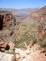 Length 9.5 miles (15.3 km) to Phantom Ranch Elevation change 4550 feet (1387 meters) Trailhead West side of Grand Canyon Village Rating (1-5) ★★★★★ Bright Angel is a long, steep trail leading to the Colorado River and Phantom Ranch, but the path is well-used, with water at intervals and one campsite (plus ranger station) half way along, at Havasupai Gardens (4.6 miles). This is the most popular of the longer trails in the park, though most people walk only a short distance. Start point is next to Kolb Studio in Grand Canyon Village, near the railway terminus. The trail is shared with mules so is often rather malodorous. |
Cedar Mountain Trail Length 1.7 miles (2.7 km) to the canyon viewpoint, 2.3 miles (3.7 km) to the Cape Solitude Trail Elevation change 630 feet (192 meters) Trailhead Desert View, near the employee residence area Rating (1-5) ★★★★★ Flat-topped Cedar Mountain is clearly visible looking east from Desert View, and may be reached by a 4WD track that continues for many miles across rough lands towards the canyon of the Little Colorado River. The first couple of miles makes for a good day hike, giving good views of Tanner Canyon and the Colorado River, while the road is also used to reach the trailhead for the 13 mile hike to Cape Solitude. |
Comanche Point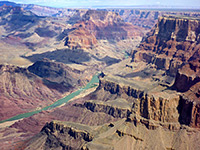 Length 6.2 miles (10 km) Elevation change 670 feet (204 meters) Trailhead Desert View, near the employee residence area Rating (1-5) ★★★★★ The remote, trailless overlook of Comanche Point is reachable by a long but not difficult hike, initially along a disused 4WD track starting near Desert View. The last section is cross-country, down a shallow ravine and steeply up to the point, which looks out over many miles of the Colorado River; one of the best views on the south (or east) rim. |
Dripping Spring Trail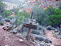 Length 3.1 miles (5 km) Elevation change 1400 feet (427 meters) Trailhead Hermits Rest, accessible by private vehicle in winter, free shuttlebus at other times Rating (1-5) ★★★★★ At Dripping Spring, water drips slowly from a huge overhanging sandstone cliff at the head of a side canyon. The path to the spring combines the first 1.6 miles of the Hermit Trail with a mostly level traverse around the two very deep upper forks of Hermit Creek, and then a short way up the side valley. Past the falls, a fainter path continues back up the cliffs to a little-used trailhead on the rim. |
|
Escalante Route Length 12 miles (19.3 km) Elevation change 1300 feet (396 meters) Trailhead Parking area for the New Hance Trail; also accessible via the Tanner Trail Rating (1-5) ★★★★★ The Escalante Route forms a easterly extension of the Tonto Trail, starting and finishing close to the Colorado River but with a middle section that climbs high above, passing over a narrow ridge between Escalante and Cardenas creeks. The west and east ends of the route may be accessed via the New Hance and Tanner trails respectively, forming a total loop of 29 miles (plus 6 miles along the park road). |
Grandview Trail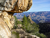 Length 3 miles (4.8 km) to Horseshoe Mesa Elevation change 2500 feet (762 meters) Trailhead Grandview Point, half way along the East Rim Drive Rating (1-5) ★★★★★ This path starts at Grandview Point, descends very steeply, follows a ridge then drops quite sharply again down to Horseshoe Mesa, which has excellent views up and down the Grand Canyon, and is the site of some old copper mines. Grandview Trail then meets the Tonto Trail, allowing for continuation hikes east or west, though unlike most long-distance routes that descend from the South Rim, the Grandview Trail does not reach the Colorado River. The mesa has several sites for primitive camping. |
Hance Creek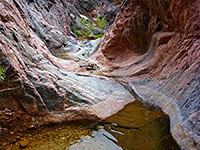 Length 8.5 miles (13.7 km) Elevation change 4860 feet (1481 meters) Trailhead Grandview Point, half way along the East Rim Drive Rating (1-5) ★★★★★ A route rather than a path; the lower section of Hance Creek forms a deep, twisting canyon through the Tapeats sandstone then the Vishnu schist, forming many pools, cascades and waterfalls, and may be followed by a strenous off-trail hike, ending at Sockdolager Rapids on the Colorado River. Three places require climbing high above the canyon floor to pass obstacles, traversing steep and unstable slopes. Access is via the Grandview Trail then a short section of the Tonto Trail. |
Hermit Trail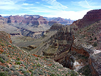 Length 9 miles (14.5 km) Elevation change 4340 feet (1323 meters) Trailhead Hermits Rest, at the end of the West Rim Drive Rating (1-5) ★★★★★ A mostly unmaintained but popular hike from Hermits Rest at the end of the West Rim Drive, the Hermit Trail winds steeply down the cliffs on the east side of Hermit Creek, then, after a short section of the Tonto Trail, continues descending to the Colorado. The round trip can be done by experienced hikers in one long day, but for overnight trips, backcountry camping is available either beside the Colorado or at the Hermit Creek campsite, about 1.5 miles from the river. |
Mimbreno, Mescalero, Jicarilla and Piute Points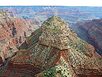 Length 15 miles (24.1 km) loop Elevation change 400 feet (122 meters) Trailhead Sheep Tank, 14.8 miles from Tusayan along FR 328 Rating (1-5) ★★★★★ Four remote promontories along the south rim of the Grand Canyon, west of Hermits Rest, reached by off-trail hiking across the forested plateau, starting from road FR 328. The views include several remote gorges, including the exotically-named Turquoise, Sapphire, Agate and Topaz canyons, many features on the opposite side of the river, and the Colorado itself, which is clearly visible from several locations. |
New Hance Trail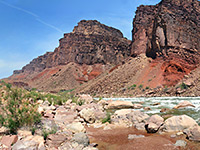 Length 8 miles (12.9 km) Elevation change 4530 feet (1381 meters) Trailhead Unmarked location along the East Rim Drive, west of Moran Point Rating (1-5) ★★★★★ Also known as Red Canyon Trail, this is a lesser used path that starts from an unmarked trailhead on the rim half a mile southwest of Moran Point, and descends gradually down colorful Red Canyon to the Colorado. The route was constructed by a miner (John Hance) in the 1880s, to replace an older trail in this area, down Hance Creek. New Hance is a difficult hike - vying with the Boucher Trail to be the most strenuous on the South Rim - but still one that can be done as a round trip in one day. |
Plateau Point Trail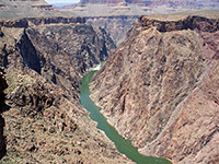 Length 1.5 miles (2.4 km) Elevation change 80 feet (24 meters) Trailhead West side of Grand Canyon Village, from where the start of the trail is 4.8 miles away Rating (1-5) ★★★★★ Forking off the Bright Angel Trail at the north side of Havasupai Gardens, this nearly level route crosses the Tonto Bench to a viewpoint at the edge of the inner canyon gorge, 1,300 feet above the Colorado River. The point is 6.3 miles from the Bright Angel trailhead, and so reachable on a day hike. |
|
Rim Trail Length 13 miles (20.9 km) for the full length; most people just hike a short section Elevation change minor Trailhead Rail-side parking lot at Grand Canyon Village; many other access points east and west Rating (1-5) ★★★★★ The Rim Trail links Mather Point with Hermits Rest, following right next to the canyon edge, and so usually close to the road as well. The easiest section is paved, around Grand Canyon Village, though all the path is quite level and not at all difficult. The free canyon shuttles can be used to jump to specific points along the way. The most popular section is probably between Yavapai Point and Grand Canyon Village, overlooking the course of the Bright Angel Trail, though for solitude the nicest stretch is either side of Pima Point. |
Shoshone Point Trail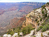 Length 1 miles (1.6 km) Elevation change level Trailhead Small parking area along the East Rim Drive Rating (1-5) ★★★★★ One of the least-visited of the named overlooks of the South Rim, Shoshone Point may be reached by an unpaved forest road though vehicular access requires special permission from the NPS. The road is open without restrictions for hikers, who reach the rim after a gentle 20 minute stroll through airy woodland of ponderosa pines. At road's end, the cliffs form a narrow promontory, jutting out from the plateau, and affording views of more than 180° of the Grand Canyon |
|
South Bass Trail Length 7.8 miles (12.6 km) Elevation change 4400 feet (1341 meters) Trailhead North end of Pasture Wash Road Rating (1-5) ★★★★★ South Bass is an unmaintained but good condition and easy-to-follow trail to the Colorado River, beginning near Pasture Point, only 12 miles west of Hermits Rest, at the end of the West Rim Drive, but requiring a journey on sometimes rough roads of over 30 miles to the trailhead - partly across the Havasupai Reservation; in theory an extra fee is necessary to cross the short section of tribal land though there is usually no-one to collect it. The route begins along Rowe Well Road, near Grand Canyon Village. The trail has several junctions with other paths leading east and west along this very remote section of the canyon. |
South Kaibab Trail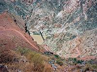 Length 6.5 miles (10.5 km) Elevation change 4820 feet (1469 meters) Trailhead Along the side road to Yaki Point, which is reachable either by free shuttlebus or a half mile walk from the highway Rating (1-5) ★★★★★ Another busy but strenuous rim to river route, with no water along the way, the South Kaibab Trail runs for much of its length along a narrow ridge, so views in all directions are quite unobstructed. This is the best (and shortest) trail for an all day, round trip hike to the Colorado River - but for fit hikers only; it involves the greatest elevation change of any south rim route. The path begins near Yaki Point, a location only reachable by the park shuttlebus. |
Tanner Trail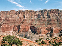 Length 9 miles (14.5 km) Elevation change 4600 feet (1402 meters) Trailhead Along the short side road to Lipan Point, 1.7 miles west of Desert View Rating (1-5) ★★★★★ Unmaintained, very steep near the start, and lacking any water, the Tanner Trail starts at Lipan Point, descends a side canyon, passes around two large mesas (Escalante and Cardenas buttes), drops steeply again through the Redwall layer around Tanner Canyon then becomes more moderate, passing through open, undulating land to the Colorado River, joining it opposite Unkar Creek. |
Tonto Trail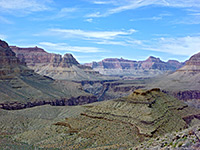 Length 92 miles (148 km) Elevation change relatively minor Trailhead Accessed from 8 points along the South Rim; most central is the Bright Angel Trailhead, in Grand Canyon Village Rating (1-5) ★★★★★ By far the longest trail in Grand Canyon National Park, Tonto begins at the lower end of the New Hance Trail in the east and follows the gorge all the way to Garnet Canyon near Pasture Point in the west, along a bench at a fairly constant elevation of 3,000 feet - mostly over the Tapeats sandstone component of the Tonto group. Few people walk the entire route, but Tonto intersects many other paths allowing for hikes along certain sections; the main junctions are with the South Bass, Boucher, Hermit, Bright Angel, South Kaibab, Grandview and New Hance trails. The Tonto Trail winds in and out of many tributary canyons, and its 92 miles equates to less than 40 miles along the river. |
|
Waldron Trail Length 2 miles (3.2 km) Elevation change 980 feet (299 meters) Trailhead 3.4 miles along a forest track forking west off Rowes Well Road Rating (1-5) ★★★★★ The Waldron Trail is a short connecting route from a forest road on the rim, south of Hermits Rest, to the Hermit/Dripping Spring trails. The gradient is gentle at the start and finish, with just one steepish section in the middle, through the Coconino and Toroweap layers. The route is seldom hiked owing to the difficult trailhead access, as regular cars need to be parked about 2.5 miles away, and the last half mile is closed to all vehicles, being part of a wilderness area. |
Yuma Point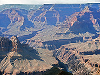 Length 6 miles (9.7 km) Elevation change 1,500 feet (457 meters) Trailhead Hermits Rest, accessible by private vehicle in winter, free shuttlebus at other times Rating (1-5) ★★★★★ Remote viewpoint of the Grand Canyon west of Hermit's Rest, reached by a rather difficult hike of which the last 2 miles is cross-country, off trail, up a rocky ravine and across a lightly wooded plateau. The Colorado River is just two miles distant, closer than at any other point to the east. The first part of the route is along the Dripping Spring Trail, starting with a steep descent into upper Hermit Creek. |
Zuni Point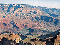 Length 0.5 miles (0.8 km) Elevation change 20 feet (6 meters) Trailhead Along the South Rim Drive (unmarked) Rating (1-5) ★★★★★ Quick, cross-country hike along the edge of the canyon rim through pine woodland to a named overlook, overlooking Papago Creek and Red Canyon. As well as trees the plateau is dotted with various species of cacti, all bearing beautiful flowers in summer |
Grand Canyon Trails - Havasupai Indian Reservation
Havasu Canyon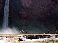 Length 10.5 miles (16.9 km) to Mooney Falls Elevation change 3600 feet (1097 meters) Trailhead Hualapai Hilltop, at the end of a long, lonely paved road Rating (1-5) ★★★★★ In the remote Havasupai Indian Reservation, this famous trail descends Hualapai and Havasu Canyons to the Colorado River, past Supai village, Havasu Falls, Mooney Falls and many other beautiful cascades and waterfalls. Many people camp for at least one night, but day trips are possible, Mooney Falls being the usual turn-around point. The route starts in a wide, exposed canyon but the cliffs soon close in and most of the remainder is confined.Now only possible as part of an expensive, overnight trip. |
All Contents © Copyright The American Southwest | Comments and Questions | Contribute | Affiliate Marketing Disclosure | Site Map