Bright Angel Trail, Grand Canyon National Park
Arizona > Grand Canyon National Park > South Rim > Hiking > Bright Angel Trail
Bright Angel Trail
Popular and spectacular route from Grand Canyon Village to Havasupai Gardens, the Tonto Bench, Plateau Point (via a side trail) and the Colorado River
Length: 9.5 miles (to Phantom Ranch)
Elevation change: 4,500 feet
Difficulty: Long, steep and strenuous, though drinking water is available along the way
Type: One way; connects with the Tonto, South Kaibab and North Kaibab trails
Usage: Heavy; also used by mules
Season: Passable all year, but the upper reaches are snow covered in winter, and all is very hot in summer
Trailhead: West side of Grand Canyon Village
Rating (1-5): ★★★★★

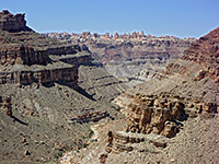
One of only two fully maintained hiking routes into the Grand Canyon from the south rim (South Kaibab is the other), the Bright Angel Trail begins near the main visitor complex, at the start of the Hermit's Rest road, and follows the course of Garden Creek, reaching the Colorado after 9.5 miles and a descent of over 4,500 feet. This is the most popular long distance trail in the national park, and the 'easiest' by which to walk to the river, although most hikers turn back a long way before - one common target is the first of two rest stations after 1.5 miles (the second is after 3 miles), which makes for a round trip of 2 hours or so.
The NPS issue stern warnings about the dangers of trying to hike all the way to the river and back in one day, though the journey is quite possible for fit hikers, assuming the weather is not too hot - on some days in midsummer the temperatures of the inner canyon can exceed 110°F, making the trip potentially hazardous. A more reasonable day hike destination is Plateau Point, a viewpoint of the Colorado River, which is reached by a 1.5 mile spur trail for a total trip (one-way) of 6.3 miles.
The big advantage of the Bright Angel route over other rim to river paths is that drinking water is available at four locations - the two rest stations, Havasupai Gardens (4.5 miles) and Phantom Ranch at the trail's end - thus mitigating the main danger of Grand Canyon hiking, which is not carrying adequate water. Havasupai Gardens was formerly known as Indian Garden, the name change occurring in November 2022, after consultation with the Havasupai tribe, members of which used to live at this place, the last being evicted in 1928. Much of the wide, well used, well maintained but often very dusty trail is along the Garden Creek side canyon so the views are more restricted than on the South Kaibab Trail, which follows a ridge downwards, but the scenery is of course still breathtaking.
Rather than hiking, many people opt to travel by mule, which requires reservations many months in advance. Livestock have priority on the trails they use so travelers on foot have to stop and let them pass, and since the mules walk in long convoys and are slow moving as well as quite smelly, they can be rather a nuisance.
Bright Angel Trail topographic map, South Rim location map.
17 views of the Bright Angel Trail and Plateau Point.
Scenes along the Bright Angel Trail (mp4; 2:48 min; 42.7 mb).
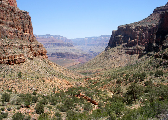
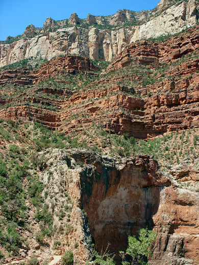
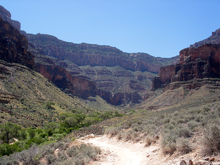
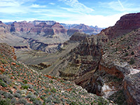
The Bright Angel trailhead is towards the west side of Grand Canyon Village, right next to the Hermits Rest shuttle stop and immediately west of Kolb Studio. The nearest parking is 1/3 mile away beside the railway tracks at Grand Canyon Station (Lot D). The first 3.5 miles (2,600 feet descent) of the trail are down the cliffs around the side canyon of Garden Creek, so the views remain broadly the same, of the lower end of the creek, the flat land extending to Plateau Point, and Bright Angel Canyon on the North Rim; the landscape does not open out until after Havasupai Gardens, when many more distant cliffs and buttes are visible. The downwards gradient is fairly constant right from the trailhead, descending via numerous long or short switchbacks across bushy hillsides that are in full sun much of the day, though occasional shade is provided by trees or overhanging cliffs. In winter, however, the upper 2 miles are in shadow all day, so the path is likely to be icy. Two sections traverse sheer cliffs (Coconino sandstone and Redwall limestone), while the remainder is across more ledgy, sloping strata of the Hermit, Esplanade and Supai layers. The surface of the trail is formed of bare rock, pebbles or hard pressed dirt, anchored at intervals by wooden steps, and all (in dry weather) covered in a thick layer of dust caused by the large number of hikers, and the frequent mule trains.
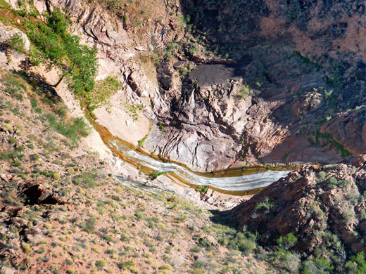
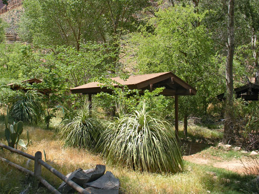
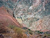
The first landmarks are two short tunnels (0.2 and 0.7 miles from the start), taking the path through cliffs of Coconino sandstone. After several more switchbacks, the 1.5 mile resthouse appears - a suitable destination for first time Grand Canyon hikers. This has shade, seating, drinking water and (in season) an NPS ranger in attendance, The next part of the trail becomes gradually more exposed and a little steeper; it crosses a small stream (the upper part of Garden Creek) and descends steadily towards the 3 mile resthouse, which is visible from some distance above. Rather fewer people make it this far, a location 2,100 feet below the rim but less than a third of the way to the trail's end at Phantom Ranch. Past here, following a speedy descent through the Redwall limestone, the route becomes much less steep, and soon starts to move northeastwards, away from the cliffs and along the shallow valley of Garden Creek, where the bushes are mixed with cacti and yucca. After nearly a mile of easy walking, a sign marks the start of Havasupai Gardens - a 1/3 mile long section of the creek with permanently flowing, spring-fed water that sustains a cool, shady patch of tall cottonwoods and other greenery. In amongst the trees are various buildings, a ranger station, a network of paths, a small herd of deer and the Havasupai Gardens campground, set right next to the creek. Drinking water is available at several places, and an emergency phone.
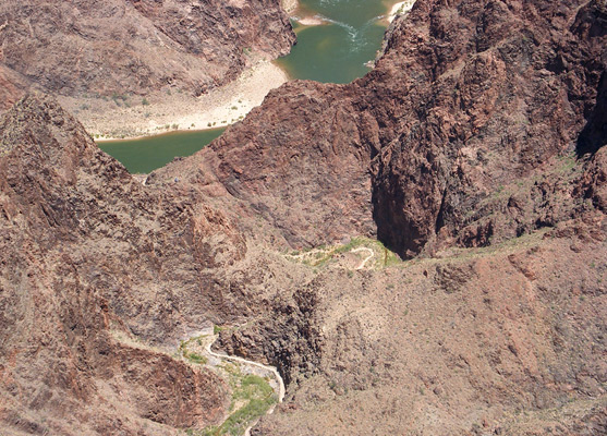
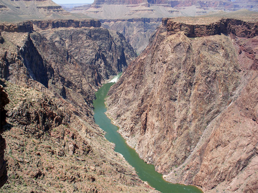
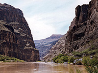
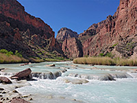
The trail splits at the far side of Havasupai Gardens; right is a continuation of the Bright Angel Trail while left is the Plateau Point/Tonto Trail. The main route continues descending fairly gradually next to the cottonwood tree-lined Garden Creek, crosses a ridge, drops much more steeply into a larger drainage (Pipe Creek) via an exposed series of switchbacks known as the Devils Corkscrew, then continues at stream level one more mile to the Colorado; it next runs alongside the river for a while, traversing the sandy hillside about 50 feet above the water, before crossing the river on a suspension bridge. From here the campsite and lodge at Phantom Ranch are a short walk away up the lower end of Bright Angel Creek, where two other paths branch off: the North Kaibab Trail upstream along the creek, and the Clear Creek Trail to the east.
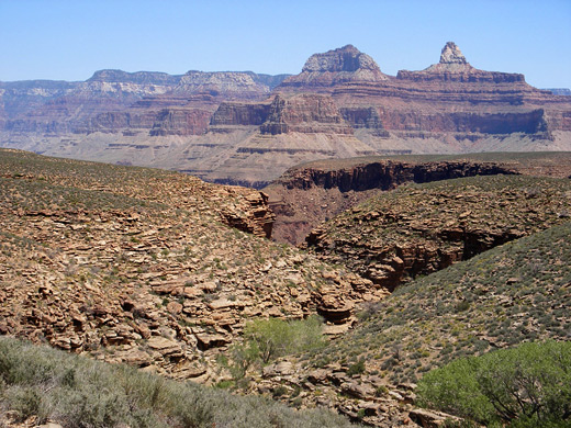
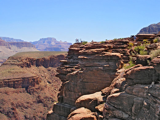
The 1.5 mile spur trail to Plateau Point soon moves out of the shade of Havasupai Gardens across a desert-like plateau formed of light brown Tapeats sandstone, covered by sparse grass dotted with occasional barrel cacti and small bushes. The terrain is nearly level, though split by a few shallow gullies, tributaries of Garden Creek to the north. A junction with the Tonto Trail is reached after 0.8 miles, after which the remaining 0.7 miles to Plateau Point is quite straight, ascending slightly to a flat summit then dropping down a little at the far side, past a water tank to a railed viewpoint right at the edge of the Granite Gorge, 1,300 feet directly above the Colorado. About 3 miles of the river are in view, from Bright Angel Canyon to the Horn Creek Rapids; a little more can be seen by walking westwards a way along the rim. The scene is dominated by the dark, rugged igneous cliffs of the inner gorge, formed of Vishnu schist - the oldest rocks in the Grand Canyon. The strata on the far side are tilted, red brown in color but with some brighter red patches of Hakatai shale, the same rocks found most prominently in the lower end of Red Canyon along the New Hance Trail.
The NPS issue stern warnings about the dangers of trying to hike all the way to the river and back in one day, though the journey is quite possible for fit hikers, assuming the weather is not too hot - on some days in midsummer the temperatures of the inner canyon can exceed 110°F, making the trip potentially hazardous. A more reasonable day hike destination is Plateau Point, a viewpoint of the Colorado River, which is reached by a 1.5 mile spur trail for a total trip (one-way) of 6.3 miles.
The big advantage of the Bright Angel route over other rim to river paths is that drinking water is available at four locations - the two rest stations, Havasupai Gardens (4.5 miles) and Phantom Ranch at the trail's end - thus mitigating the main danger of Grand Canyon hiking, which is not carrying adequate water. Havasupai Gardens was formerly known as Indian Garden, the name change occurring in November 2022, after consultation with the Havasupai tribe, members of which used to live at this place, the last being evicted in 1928. Much of the wide, well used, well maintained but often very dusty trail is along the Garden Creek side canyon so the views are more restricted than on the South Kaibab Trail, which follows a ridge downwards, but the scenery is of course still breathtaking.
Rather than hiking, many people opt to travel by mule, which requires reservations many months in advance. Livestock have priority on the trails they use so travelers on foot have to stop and let them pass, and since the mules walk in long convoys and are slow moving as well as quite smelly, they can be rather a nuisance.
Maps
Bright Angel Trail topographic map, South Rim location map.
Photographs
17 views of the Bright Angel Trail and Plateau Point.
Video
Scenes along the Bright Angel Trail (mp4; 2:48 min; 42.7 mb).


General Description of the Bright Angel Trail
The Bright Angel trailhead is towards the west side of Grand Canyon Village, right next to the Hermits Rest shuttle stop and immediately west of Kolb Studio. The nearest parking is 1/3 mile away beside the railway tracks at Grand Canyon Station (Lot D). The first 3.5 miles (2,600 feet descent) of the trail are down the cliffs around the side canyon of Garden Creek, so the views remain broadly the same, of the lower end of the creek, the flat land extending to Plateau Point, and Bright Angel Canyon on the North Rim; the landscape does not open out until after Havasupai Gardens, when many more distant cliffs and buttes are visible. The downwards gradient is fairly constant right from the trailhead, descending via numerous long or short switchbacks across bushy hillsides that are in full sun much of the day, though occasional shade is provided by trees or overhanging cliffs. In winter, however, the upper 2 miles are in shadow all day, so the path is likely to be icy. Two sections traverse sheer cliffs (Coconino sandstone and Redwall limestone), while the remainder is across more ledgy, sloping strata of the Hermit, Esplanade and Supai layers. The surface of the trail is formed of bare rock, pebbles or hard pressed dirt, anchored at intervals by wooden steps, and all (in dry weather) covered in a thick layer of dust caused by the large number of hikers, and the frequent mule trains.
Bright Angel Trailhead to Havasupai Gardens
The first landmarks are two short tunnels (0.2 and 0.7 miles from the start), taking the path through cliffs of Coconino sandstone. After several more switchbacks, the 1.5 mile resthouse appears - a suitable destination for first time Grand Canyon hikers. This has shade, seating, drinking water and (in season) an NPS ranger in attendance, The next part of the trail becomes gradually more exposed and a little steeper; it crosses a small stream (the upper part of Garden Creek) and descends steadily towards the 3 mile resthouse, which is visible from some distance above. Rather fewer people make it this far, a location 2,100 feet below the rim but less than a third of the way to the trail's end at Phantom Ranch. Past here, following a speedy descent through the Redwall limestone, the route becomes much less steep, and soon starts to move northeastwards, away from the cliffs and along the shallow valley of Garden Creek, where the bushes are mixed with cacti and yucca. After nearly a mile of easy walking, a sign marks the start of Havasupai Gardens - a 1/3 mile long section of the creek with permanently flowing, spring-fed water that sustains a cool, shady patch of tall cottonwoods and other greenery. In amongst the trees are various buildings, a ranger station, a network of paths, a small herd of deer and the Havasupai Gardens campground, set right next to the creek. Drinking water is available at several places, and an emergency phone.
Havasupai Gardens to the Colorado River
The trail splits at the far side of Havasupai Gardens; right is a continuation of the Bright Angel Trail while left is the Plateau Point/Tonto Trail. The main route continues descending fairly gradually next to the cottonwood tree-lined Garden Creek, crosses a ridge, drops much more steeply into a larger drainage (Pipe Creek) via an exposed series of switchbacks known as the Devils Corkscrew, then continues at stream level one more mile to the Colorado; it next runs alongside the river for a while, traversing the sandy hillside about 50 feet above the water, before crossing the river on a suspension bridge. From here the campsite and lodge at Phantom Ranch are a short walk away up the lower end of Bright Angel Creek, where two other paths branch off: the North Kaibab Trail upstream along the creek, and the Clear Creek Trail to the east.
Plateau Point
The 1.5 mile spur trail to Plateau Point soon moves out of the shade of Havasupai Gardens across a desert-like plateau formed of light brown Tapeats sandstone, covered by sparse grass dotted with occasional barrel cacti and small bushes. The terrain is nearly level, though split by a few shallow gullies, tributaries of Garden Creek to the north. A junction with the Tonto Trail is reached after 0.8 miles, after which the remaining 0.7 miles to Plateau Point is quite straight, ascending slightly to a flat summit then dropping down a little at the far side, past a water tank to a railed viewpoint right at the edge of the Granite Gorge, 1,300 feet directly above the Colorado. About 3 miles of the river are in view, from Bright Angel Canyon to the Horn Creek Rapids; a little more can be seen by walking westwards a way along the rim. The scene is dominated by the dark, rugged igneous cliffs of the inner gorge, formed of Vishnu schist - the oldest rocks in the Grand Canyon. The strata on the far side are tilted, red brown in color but with some brighter red patches of Hakatai shale, the same rocks found most prominently in the lower end of Red Canyon along the New Hance Trail.
Bright Angel and Plateau Point Trails - Similar Hikes
All Contents © Copyright The American Southwest | Comments and Questions | Contribute | Affiliate Marketing Disclosure | Site Map