Slot canyons of the Escalante River and its tributaries.
Escalante Slot Canyon Tours
Although associated with the Grand Staircase-Escalante National Monument, most of the Escalante River and its countless tributaries are within Glen Canyon National Recreation Area, and some of the more southerly side canyons are best explored by boat as the lower 15 miles of the river are now part of Lake Powell. The only vehicular access to the area is from the north, primarily via the Hole-in-the-Rock Road on the west side of the river, starting along UT 12, five miles east of Escalante. The upper reaches are crossed by Highway 12, the Burr Trail, and several lesser tracks, while the Wolverine Road gives access to some canyons in the northeast, but the southeast region adjoining the lake is completely unreachable by road - the Waterpocket Fold forms a barrier to the east while the land is too uneven to the north, hence this is one of the most remote, least visited areas of Utah.
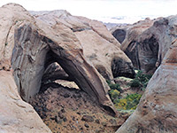
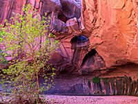
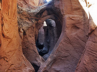
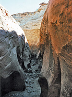
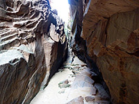
Besides its famous canyons, the Escalante region has a number of impressive arches and natural bridges, plus many springs, streams, sheer cliffs and ridges, sand dunes and desert plains, but mostly just vast expanses of colorful, eroded, layered slickrock, the dominant component being the familiar reddish Navajo sandstone. The longer canyons are deep, sheer-walled but relatively wide, and often carry permanent water; the most visited locations (all with official trailheads) being Calf Creek, Coyote Gulch, Death Hollow, Deer Creek, Harris Wash, Hurricane Wash, Pine Creek ('The Box'), Twentyfive Mile Wash, The Gulch and the Escalante River itself (the upper section), but there are many others. Those on the east side of the river are the deepest and hold a more significant amount of water, though the majority are wild, rarely explored and unnamed even on topographical maps.
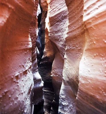
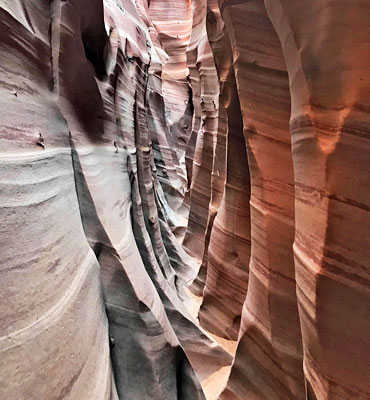
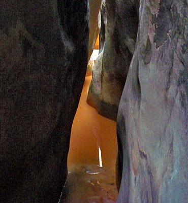
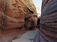
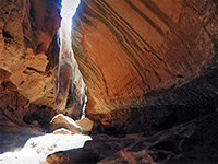
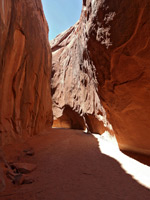
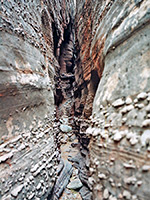
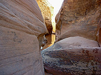
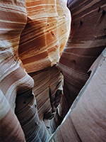
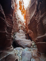
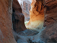
The Escalante slot canyons are for the most part smaller drainages, tributaries of the main gorges, and there are many dozen if not several hundred of them - ranging from the quite long but not especially enclosed (eg Little Death Hollow, Llewellyn Gulch, Red Breaks) to extreme slots so narrow that traversing requires stemming sometimes as much as 50 feet above the floor, in conjunction with the usual downclimbing, rappelling, wading and swimming. Canyons such as Brimstone Gulch (lower end), Davis Gulch and Egypt 3 give an idea of the character of these places without need for technical equipment. Other good slots include, on the east side of the river, the canyons of Choprock, Neon, Baker and Ringtail, or on the west side, Fortymile Creek, Willow Creek, Cottonwood Gulch, and many tributaries of Coyote Gulch and its Dry Fork. In most cases the main drainage has various different branches, all forming slot canyons.
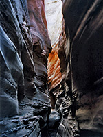
Big Horn Canyon
★★★★★
★★★★★
3.8 miles, 700 feet
Medium depth drainage that has several stretches of shallow narrows in its east (main) fork, and a short but deeper, more colorful and photogenic slot in the west forkBrimstone Gulch
★★★★★
★★★★★
2.9 miles, 350 feet
Extremely dark and enclosed slot that eventually becomes too narrow to explore at ground levelDry Fork of Coyote Gulch
★★★★★
★★★★★
1.1 miles, 200 feet
Long drainage containing 0.7 miles of moderately deep and narrow passageways near its upper end, which alternate with wider stretches, patches of bright green shrubbery, sandbanks and pebble beaches. Usually explored in conjunction with the Peekaboo Gulch and Spooky Gulch tributariesDavis Gulch
★★★★★
★★★★★
2.7 miles, 400 feet
Testing narrows with many chokestones and tight sections requiring downclimbing - at the upper end of a canyon that becomes much wider and deeper, contains a huge natural arch, and eventually meets Lake PowellEgypt 3
★★★★★
★★★★★
2.7 miles, 400 feet
Excellent narrows in three distinct sections; a long succession of interlinked potholes, followed by extremely narrow passageways through strangely textured rocks, and finally a lower technical section with drop-off and poolEscalante River Slot Canyon
★★★★★
★★★★★
1.4 miles, 500 feet
Minor tributary ravine on the south side of the Escalante River, quite easily accessible from Hwy 12. Forms a nice short slot, with shallow pools and twisting passages through dark-colored sandstoneHarris Wash
★★★★★
★★★★★
5.3 miles, 300 feet
Long, deep and relatively wide drainage providing an obstruction-free hiking route to the Escalante River. Four tributaries forms slots, most unusual (and shortest) being stripy Zebra Slot and enclosed Tunnel SlotLittle Death Hollow
★★★★★
★★★★★
8 miles, 600 feet
Remote, east-side Escalante tributary that after a long open section, eventually forms a fine slot canyon, with over 2 miles of narrow, twisting passageways through colorful Wingate sandstoneLlewellyn Gulch
★★★★★
★★★★★
6 miles, 650 feet
Beautiful, secluded canyon that starts beneath the red cliffs of Fiftymile Point and meets Lake Powell, forming nice, slot-like passageways in the upper part, and a wider gorge lower down, containing a permanent streamNeon Canyon
★★★★★
★★★★★
4.6 miles, 1100 feet
Long slot canyon, requiring ropes to explore fully, but ending at the more accessible 'Golden Cathedral', a beautiful natural amphitheater formed by overhanging cliffs streaked with desert varnish, containing a triple natural bridge above a large poolPeekaboo Gulch
★★★★★
★★★★★
1.1 miles, 180 feet
Minor tributary of Dry Fork of Coyote Gulch forming a short slot at its southern end, containing sharp fins, interlinked potholes several small archesRed Breaks
★★★★★
★★★★★
3 miles, 500 feet
Extensive, branched, north-side tributary of Harris Wash in a rarely visited area. Contains shallow slots for most of its length, but has some deeper passages in the less accessible northern stretchesSpencer Canyon
★★★★★
★★★★★
4 miles, 550 feet
Short, branched, south side tributary of the Escalante River; longest fork is straight and vertical-walled, with a tight, dark slot in the upper endSpooky Gulch
★★★★★
★★★★★
1.2 miles, 220 feet
Short, narrow, claustrophobic slot canyon, a tributary of Dry Fork of Coyote GulchEscalante Slot Canyon Tours
Although associated with the Grand Staircase-Escalante National Monument, most of the Escalante River and its countless tributaries are within Glen Canyon National Recreation Area, and some of the more southerly side canyons are best explored by boat as the lower 15 miles of the river are now part of Lake Powell. The only vehicular access to the area is from the north, primarily via the Hole-in-the-Rock Road on the west side of the river, starting along UT 12, five miles east of Escalante. The upper reaches are crossed by Highway 12, the Burr Trail, and several lesser tracks, while the Wolverine Road gives access to some canyons in the northeast, but the southeast region adjoining the lake is completely unreachable by road - the Waterpocket Fold forms a barrier to the east while the land is too uneven to the north, hence this is one of the most remote, least visited areas of Utah.
Besides its famous canyons, the Escalante region has a number of impressive arches and natural bridges, plus many springs, streams, sheer cliffs and ridges, sand dunes and desert plains, but mostly just vast expanses of colorful, eroded, layered slickrock, the dominant component being the familiar reddish Navajo sandstone. The longer canyons are deep, sheer-walled but relatively wide, and often carry permanent water; the most visited locations (all with official trailheads) being Calf Creek, Coyote Gulch, Death Hollow, Deer Creek, Harris Wash, Hurricane Wash, Pine Creek ('The Box'), Twentyfive Mile Wash, The Gulch and the Escalante River itself (the upper section), but there are many others. Those on the east side of the river are the deepest and hold a more significant amount of water, though the majority are wild, rarely explored and unnamed even on topographical maps.
The Escalante slot canyons are for the most part smaller drainages, tributaries of the main gorges, and there are many dozen if not several hundred of them - ranging from the quite long but not especially enclosed (eg Little Death Hollow, Llewellyn Gulch, Red Breaks) to extreme slots so narrow that traversing requires stemming sometimes as much as 50 feet above the floor, in conjunction with the usual downclimbing, rappelling, wading and swimming. Canyons such as Brimstone Gulch (lower end), Davis Gulch and Egypt 3 give an idea of the character of these places without need for technical equipment. Other good slots include, on the east side of the river, the canyons of Choprock, Neon, Baker and Ringtail, or on the west side, Fortymile Creek, Willow Creek, Cottonwood Gulch, and many tributaries of Coyote Gulch and its Dry Fork. In most cases the main drainage has various different branches, all forming slot canyons.
Related Sections
- Grand Staircase-Escalante National Monument - general information
- Upper and Lower Calf Creek Falls - waterfalls along an Escalante tributary
All Contents © Copyright The American Southwest | Comments and Questions | Contribute | Affiliate Marketing Disclosure | Site Map