Little Death Hollow
Remote, east-side Escalante tributary that after a long open section, eventually forms a fine slot canyon, with over 2 miles of narrow, twisting passageways
Length: 8 miles, from Wolverine Road to Horse Canyon
Difficulty: Easy to moderate; a long hike, but there are few obstructions in the narrows
Management: BLM
Rocks: Wingate sandstone
Season: Late spring, summer, fall; not right after heavy rains
Trailhead: 12 miles along Wolverine Loop Road, which may need a HCV
Rating (1-5): ★★★★★
Difficulty: Easy to moderate; a long hike, but there are few obstructions in the narrows
Management: BLM
Rocks: Wingate sandstone
Season: Late spring, summer, fall; not right after heavy rains
Trailhead: 12 miles along Wolverine Loop Road, which may need a HCV
Rating (1-5): ★★★★★

There are two Death Hollows near Escalante - the large one begins north of the town as a seasonal stream in a shallow valley high in the Boulder Mountains then steadily deepens and has lengthy narrow sections, running water and deep pools for a total distance of over 20 miles. The little version is not much shorter overall but the interesting part is the lower 7 miles, for here the wash becomes enclosed by high red sandstone cliffs then deepens and narrows and enters a very fine slot canyon - long, pretty and colorful, and in dry weather at least, lacking any great obstacles.
The canyon may be visited in one day, or as part of a backpacking trip that continues to other nearby ravines in this part of the middle Escalante River area.
Little Death Hollow is quite remote, on the less accessible east side of the Escalante River, but well enough known to have an official trailhead with a hike register. The wash starts in the rolling land beneath the west side of the Circle Cliffs and runs southwest, cutting through the cliffs where the narrows are found and joins Horse Canyon which in turn meets the main river, and is reached by driving 19 miles east from Boulder along the Burr Trail then turning right and heading due south on the unpaved Wolverine Loop Road. A signpost at the junction gives the distance to the trailhead as 12 miles, which takes about half an hour to drive - apart from a straight, level stretch at the start most of the route is winding, sandy and steep in places. Some parts are along or across streambeds - Horse Canyon and Wolverine Creek, so these will be impassable after wet weather and the track may be unsuitable for low clearance vehicles at any time.
Wolverine Creek also enters a narrow canyon downstream, which can be explored by itself or as one leg of a loop hike with Little Death Hollow, and it too has a marked trailhead. This is reached after 8 miles; beyond, the track climbs up from the creek and traverses a higher plateau, passing through a small part of the Wolverine Petrified Wood Natural Area - around here, the banded strata of the Chinle formation are exposed, which have many large specimens of dark-colored petrified logs. The road then drops down into the next valley, formed by Little Death Hollow, and a short spur leads to a parking/camping area next to a corral, from where the hike begins. Soon after, the main track forks, then both branches cross the rough country to the east, meeting again and eventually rejoining the Burr Trail shortly before it enters Capitol Reef National Park.
13 views of Little Death Hollow.
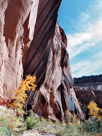
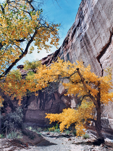
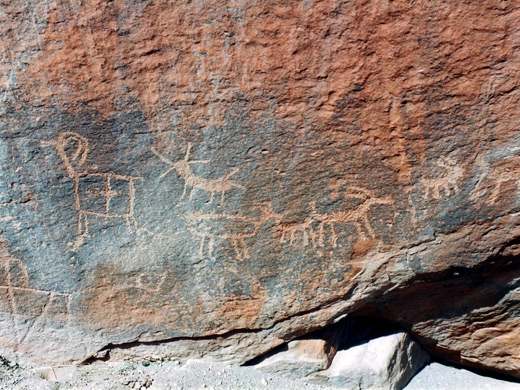
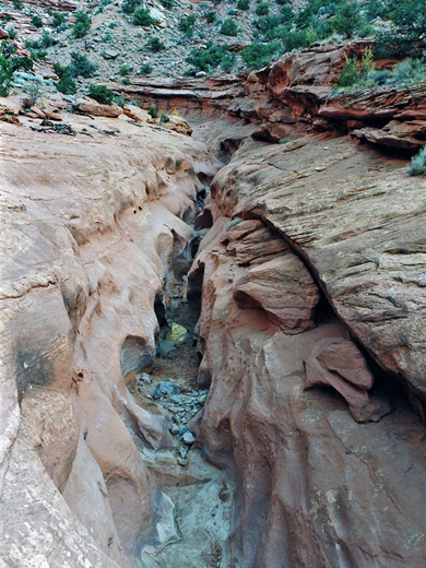
At the trailhead, the land to the north and east appears quite flat and open, but the in other direction rise the high Circle Cliffs, formed of red Wingate sandstone. The normally dry Little Death Hollow wash emerges from a breach in the cliffs about one mile distant then winds through a wide valley filled with sage bushes and grass. A well-worn cattle path sets off from the trailhead and follows mostly along the north side of the wash, crossing the sandy streamway several times before rounding a corner opposite the junction with the south fork, beyond which the canyon ahead begins to narrow somewhat. A distinctive set of petroglyphs is visible on a boulder just to the right.
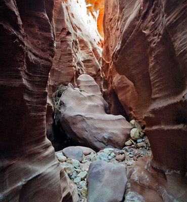
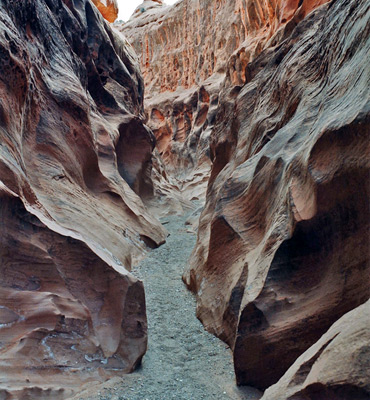
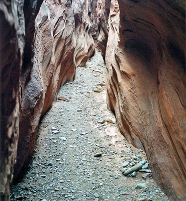
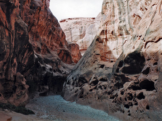
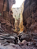
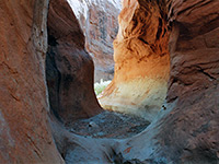
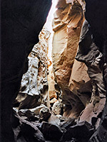
For the next hour the path runs along sand banks beside the wash, then begins to merge with the streambed as the walls gradually come closer together and the canyon starts to cut down into the Wingate layer. It passes a spring that provides a water source most of the year, and also a few very short narrow side canyons. The wash becomes more stony with variously sized boulders and also many pieces of petrified wood, washed down from the eroded strata of the Chinle formation upstream. For short sections the streambed covers all the canyon floor, but the proper narrows do not begin until about a 2.5 hour walk from the trailhead, a distance of 5 miles, but they are well worth the wait and eventually the canyon has lengthy passages only 2 feet wide, deep, quite dark in places but light enough in others to allow for good reflected light patterns.
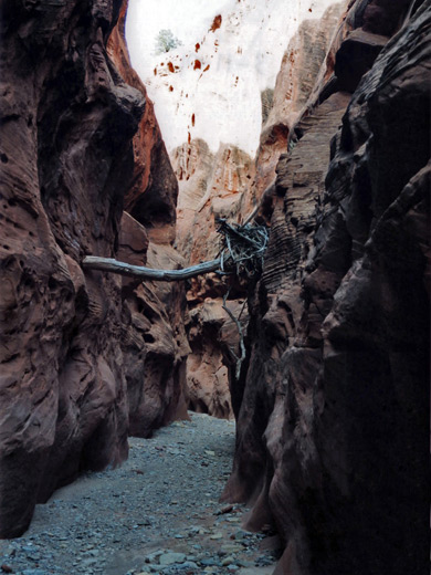
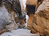
The best section is after a sequence of four chokestones, and as with all such obstacles, the difficulty of these change depending on recent weather conditions - on this occasion, the canyon was completely dry and all could be easily bypassed by climbing over or under. There are several transverse faults that provide possible climb-out places - one is usually recommended to overcome the largest chokestone, towards the end of the narrowest section, which is 10 feet high and sometimes has a large pool beyond. At some times of year the canyon has long stretches of mud and extensive standing water - judging from tidemarks along the walls some pools may be over 6 feet deep and very long.
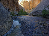
After two lesser blocking boulders Little Death Hollow becomes wider, still forming some narrow channels but with flat benches above. The streamway has much fallen rock and eroded strata as it approaches the junction with Horse Canyon, and trees, bushes and cacti grow over the crumbling canyon walls. The complete loop hike, continuing up Horse and Wolverine then along the road back to the trailhead is 16 miles which may be too much for one day, and even the hike through the narrows and back is about 12 miles, moderately strenuous and takes at least six hours.
The canyon may be visited in one day, or as part of a backpacking trip that continues to other nearby ravines in this part of the middle Escalante River area.
Location
Little Death Hollow is quite remote, on the less accessible east side of the Escalante River, but well enough known to have an official trailhead with a hike register. The wash starts in the rolling land beneath the west side of the Circle Cliffs and runs southwest, cutting through the cliffs where the narrows are found and joins Horse Canyon which in turn meets the main river, and is reached by driving 19 miles east from Boulder along the Burr Trail then turning right and heading due south on the unpaved Wolverine Loop Road. A signpost at the junction gives the distance to the trailhead as 12 miles, which takes about half an hour to drive - apart from a straight, level stretch at the start most of the route is winding, sandy and steep in places. Some parts are along or across streambeds - Horse Canyon and Wolverine Creek, so these will be impassable after wet weather and the track may be unsuitable for low clearance vehicles at any time.
Wolverine Canyon
Wolverine Creek also enters a narrow canyon downstream, which can be explored by itself or as one leg of a loop hike with Little Death Hollow, and it too has a marked trailhead. This is reached after 8 miles; beyond, the track climbs up from the creek and traverses a higher plateau, passing through a small part of the Wolverine Petrified Wood Natural Area - around here, the banded strata of the Chinle formation are exposed, which have many large specimens of dark-colored petrified logs. The road then drops down into the next valley, formed by Little Death Hollow, and a short spur leads to a parking/camping area next to a corral, from where the hike begins. Soon after, the main track forks, then both branches cross the rough country to the east, meeting again and eventually rejoining the Burr Trail shortly before it enters Capitol Reef National Park.
Photographs
13 views of Little Death Hollow.
Route Description for Little Death Hollow
At the trailhead, the land to the north and east appears quite flat and open, but the in other direction rise the high Circle Cliffs, formed of red Wingate sandstone. The normally dry Little Death Hollow wash emerges from a breach in the cliffs about one mile distant then winds through a wide valley filled with sage bushes and grass. A well-worn cattle path sets off from the trailhead and follows mostly along the north side of the wash, crossing the sandy streamway several times before rounding a corner opposite the junction with the south fork, beyond which the canyon ahead begins to narrow somewhat. A distinctive set of petroglyphs is visible on a boulder just to the right.
The Narrowing Canyon
For the next hour the path runs along sand banks beside the wash, then begins to merge with the streambed as the walls gradually come closer together and the canyon starts to cut down into the Wingate layer. It passes a spring that provides a water source most of the year, and also a few very short narrow side canyons. The wash becomes more stony with variously sized boulders and also many pieces of petrified wood, washed down from the eroded strata of the Chinle formation upstream. For short sections the streambed covers all the canyon floor, but the proper narrows do not begin until about a 2.5 hour walk from the trailhead, a distance of 5 miles, but they are well worth the wait and eventually the canyon has lengthy passages only 2 feet wide, deep, quite dark in places but light enough in others to allow for good reflected light patterns.
Chokestones
The best section is after a sequence of four chokestones, and as with all such obstacles, the difficulty of these change depending on recent weather conditions - on this occasion, the canyon was completely dry and all could be easily bypassed by climbing over or under. There are several transverse faults that provide possible climb-out places - one is usually recommended to overcome the largest chokestone, towards the end of the narrowest section, which is 10 feet high and sometimes has a large pool beyond. At some times of year the canyon has long stretches of mud and extensive standing water - judging from tidemarks along the walls some pools may be over 6 feet deep and very long.
Junction with Horse Canyon
After two lesser blocking boulders Little Death Hollow becomes wider, still forming some narrow channels but with flat benches above. The streamway has much fallen rock and eroded strata as it approaches the junction with Horse Canyon, and trees, bushes and cacti grow over the crumbling canyon walls. The complete loop hike, continuing up Horse and Wolverine then along the road back to the trailhead is 16 miles which may be too much for one day, and even the hike through the narrows and back is about 12 miles, moderately strenuous and takes at least six hours.
Nearby Slot Canyons
Little Death Hollow is one of the top 25 slot canyons
Little Death Hollow - Similar Hikes
All Contents © Copyright The American Southwest | Comments and Questions | Contribute | Affiliate Marketing Disclosure | Site Map