Bull Valley Gorge
Good, deep narrows through colorful, thin-layered sandstone, containing long muddy pools and several dryfalls, hence quite testing to explore. Below the narrows is a wider, deeper gorge sheltering a few pine trees, before the canyon meets the larger drainage of Sheep Creek
Length: 2 miles to the end of the slot, 5.5 miles to Sheep Creek
Difficulty: Moderate to strenuous - pools, mud and chokestones
Management: BLM - part of Grand Staircase-Escalante NM
Rocks: Navajo sandstone
Season: Spring, summer, fall - during dry weather, else the access road is impassable
Trailhead: Along Skutumpah Road, 10.5 miles south of Cannonville
Rating (1-5): ★★★★★

In the hilly, wooded country around the upper Paria River valley, Bull Valley Gorge is a relatively well known canyon, yet quite far from a paved road. It can be quite testing to explore as there are several dryfalls to negotiate - the highest is 12 feet - plus depending on recent weather, pools up to 4 feet deep and long patches of sticky, clayish mud may be encountered.
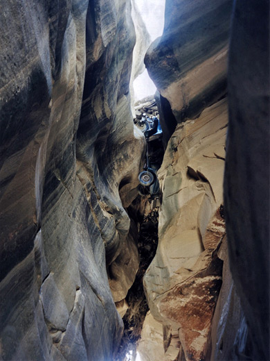
The reward for the effort needed is over a mile of a deep, narrow Navajo sandstone canyon, quite similar to Buckskin Gulch but with more variety of rock formations and colors. A unique extra feature was the wreck of a 1950s pick-up truck, wedged high above a section of narrows, which formed the base of the one road bridge across the canyon, though the truck was washed away in 2019, along with half of the bridge.
Topographic map of Bull Valley Gorge.
The easiest approach to Bull Valley Gorge is from the north end of the Cottonwood Canyon road, the paved route to Kodachrome Basin State Park - to get there, turn off along a track signposted to Johnson Canyon (Skutumpah Road), across a stony creekbed, then drive about 9 miles on the mostly good quality road that does still have some steep sections, especially the ascent up a plateau near the start. The road fords several streamways, including Willis Creek (which has a year round flow) and Sheep Creek beneath a dam, both of which may be impassable after heavy rain. The gorge is not signposted but the bridge over the canyon is quite an obvious feature. The canyon can also be reached from the south, starting along Johnson Canyon Road that joins US 89, and driving for 40 miles across Skutumpah Terrace.
10 views of Bull Valley Gorge.
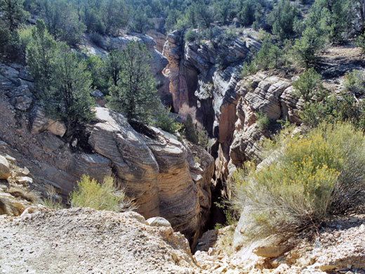
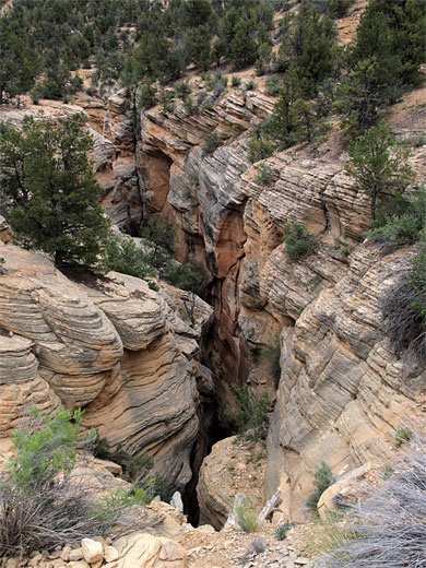
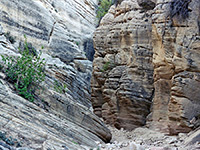
Bull Valley Gorge is very impressive when viewed from above, either side of the road bridge; it is about 100 feet deep, dark and narrow - in some places the edges are almost close enough to jump over. Mud, pools and boulders are clearly visible below, and the car wreck beneath the bridge can be seen by walking upstream a way and looking back. The surrounding land is hilly, but gently so; above the gorge is a low valley with a nearly flat floor, into which the sheer ravine cuts abruptly.
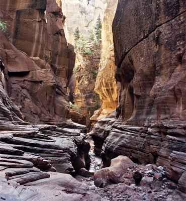
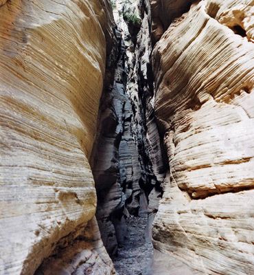
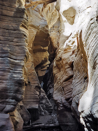
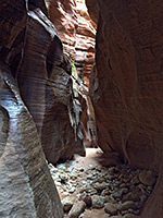
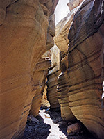
To explore the canyon, start by walking through a gate by the bridge and follow a faint path along the north side for about 15 minutes, until the gorge becomes shallow enough to jump down into. Turning back downstream, the channel deepens quickly, firstly by a 10 foot dryfall below a chokestone; a log may be in place to aid the descent. The gorge is narrow from the beginning and remains so until shortly past the road bridge. Rocks in the upper section are grey-white in color, solid, old and weathered with many narrow layers of different angles - similar to the nearby canyon of Round Valley Draw but slightly less pretty. If visiting after recent rainfall, this early part is likely to contain many pools and patches of sticky mud. The deepest wading required is generally around 3 feet - through either water or mud.
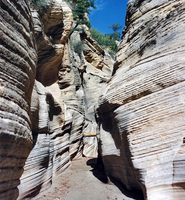
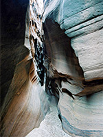
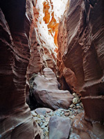
There are several other dryfalls to climb over, usually with water and mud beneath. One of 6 feet may also require a tree stump for assistance, and the tallest drop, of 12 feet, is not easily passed without using a rope; one may be left in place. This section of Bull Valley Gorge is liable to change after flash floods, however, so falls and chokestones may become more or less of a problem. The bridge is reached soon after the 12 foot dryfall, and seems a long way above, with the truck precariously wedged beneath a mass of rocks and tree trunks. Beyond this point, the canyon widens somewhat but still has sheer walls, and remains similar in appearance for another mile. Smaller pools and boulders provide minor obstacles until the cliffs become less vertical and the canyon is lighter and more open. Large pine trees begin to grow on sand banks above the streamway as Bull Valley Gorge meanders away south, joining Sheep Creek and eventually the Paria River. A round trip to this point takes from 2.5 hours, a hike which judging on the amount of footprints seems to be followed by one or two people each day in summer.
The pick-up truck was driven over the edge of the then narrow, wooden road bridge in 1954, an accident in which three men died. Their bodies were recovered but the truck was left in place, and the bridge that exists today was made by pushing large rocks and tree trunks over the wreck, forming a sturdy barrier about 15 feet thick.
The reward for the effort needed is over a mile of a deep, narrow Navajo sandstone canyon, quite similar to Buckskin Gulch but with more variety of rock formations and colors. A unique extra feature was the wreck of a 1950s pick-up truck, wedged high above a section of narrows, which formed the base of the one road bridge across the canyon, though the truck was washed away in 2019, along with half of the bridge.
Map
Topographic map of Bull Valley Gorge.
Location
The easiest approach to Bull Valley Gorge is from the north end of the Cottonwood Canyon road, the paved route to Kodachrome Basin State Park - to get there, turn off along a track signposted to Johnson Canyon (Skutumpah Road), across a stony creekbed, then drive about 9 miles on the mostly good quality road that does still have some steep sections, especially the ascent up a plateau near the start. The road fords several streamways, including Willis Creek (which has a year round flow) and Sheep Creek beneath a dam, both of which may be impassable after heavy rain. The gorge is not signposted but the bridge over the canyon is quite an obvious feature. The canyon can also be reached from the south, starting along Johnson Canyon Road that joins US 89, and driving for 40 miles across Skutumpah Terrace.
Photographs
10 views of Bull Valley Gorge.
Bull Valley Gorge Route Description
Bull Valley Gorge is very impressive when viewed from above, either side of the road bridge; it is about 100 feet deep, dark and narrow - in some places the edges are almost close enough to jump over. Mud, pools and boulders are clearly visible below, and the car wreck beneath the bridge can be seen by walking upstream a way and looking back. The surrounding land is hilly, but gently so; above the gorge is a low valley with a nearly flat floor, into which the sheer ravine cuts abruptly.
The Upper Narrows
To explore the canyon, start by walking through a gate by the bridge and follow a faint path along the north side for about 15 minutes, until the gorge becomes shallow enough to jump down into. Turning back downstream, the channel deepens quickly, firstly by a 10 foot dryfall below a chokestone; a log may be in place to aid the descent. The gorge is narrow from the beginning and remains so until shortly past the road bridge. Rocks in the upper section are grey-white in color, solid, old and weathered with many narrow layers of different angles - similar to the nearby canyon of Round Valley Draw but slightly less pretty. If visiting after recent rainfall, this early part is likely to contain many pools and patches of sticky mud. The deepest wading required is generally around 3 feet - through either water or mud.
Dryfalls
There are several other dryfalls to climb over, usually with water and mud beneath. One of 6 feet may also require a tree stump for assistance, and the tallest drop, of 12 feet, is not easily passed without using a rope; one may be left in place. This section of Bull Valley Gorge is liable to change after flash floods, however, so falls and chokestones may become more or less of a problem. The bridge is reached soon after the 12 foot dryfall, and seems a long way above, with the truck precariously wedged beneath a mass of rocks and tree trunks. Beyond this point, the canyon widens somewhat but still has sheer walls, and remains similar in appearance for another mile. Smaller pools and boulders provide minor obstacles until the cliffs become less vertical and the canyon is lighter and more open. Large pine trees begin to grow on sand banks above the streamway as Bull Valley Gorge meanders away south, joining Sheep Creek and eventually the Paria River. A round trip to this point takes from 2.5 hours, a hike which judging on the amount of footprints seems to be followed by one or two people each day in summer.
The 1954 Accident
The pick-up truck was driven over the edge of the then narrow, wooden road bridge in 1954, an accident in which three men died. Their bodies were recovered but the truck was left in place, and the bridge that exists today was made by pushing large rocks and tree trunks over the wreck, forming a sturdy barrier about 15 feet thick.
Bull Valley Gorge is one of the top 25 slot canyons
Bull Valley Gorge - Similar Hikes
All Contents © Copyright The American Southwest | Comments and Questions | Contribute | Affiliate Marketing Disclosure | Site Map