Buckskin Gulch
Longest and deepest slot canyon in the Southwest - intimidating, sheer-walled narrows that extend for 12 miles, meeting the Paria River in the middle of its own lengthy enclosed section. The whole canyon can be hiked in one day, though camping en route for one night is more common
Length: (to the Paria confluence) 13.5 miles from Wire Pass, 16.5 miles from Buckskin, 6.8 miles from Middle
Difficulty: Moderate; few major obstacles apart from long muddy pools, but the full hike is long and tiring. High flash flood danger
Management: BLM - part of Paria Canyon-Vermilion Cliffs Wilderness
Rocks: Navajo sandstone
Season: Late spring to fall, though not for several days after recent rains
Trailhead: (Wire Pass) 8.5 miles down House Rock Valley Road
Rating (1-5): ★★★★★

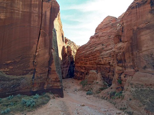
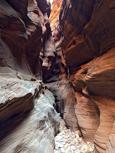
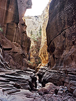
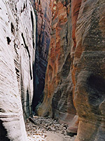
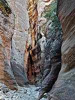
Buckskin Gulch is the longest and deepest slot canyon in the Southwest, and while others are narrower, prettier or more challenging to explore, the length and variety of the terrain in the gulch make it the best overall. The canyon is narrow for 12 miles; the cliffs become steadily higher downstream, reaching a height of 500 feet above the streambed at the end, where Buckskin Gulch meets the Paria River which also flows through a deep canyon for several miles either side of the confluence.
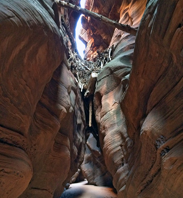
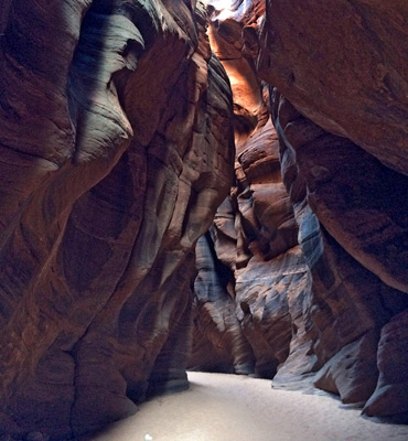
The walls of both canyons are rather dark, and the great depth means that the sun rarely illuminates the narrow passages fully, and Buckskin lacks the pretty patterns of light and color as are found in, for example, Water Holes Canyon. Still, the walls of the gulch do show the characteristic swirls and curves worn by countless millennia of floods, and they are eroded into innumerable eerie rock formations which, given a vivid imagination and the right kind of light, can resemble all kinds of distorted creatures and strange objects.
Buckskin Gulch (named on some maps as Kaibab Gulch, or The Dive) is a tributary of the Paria River that drains an area around the Vermilion Cliffs in far south Utah and joins the Paria exactly at the Utah/Arizona border, 20 miles from Lees Ferry next to the Colorado River.
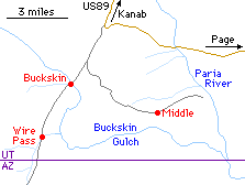
Three trailheads give access to the gulch; Middle, Wire Pass and Buckskin. The Middle Trail leads to the canyon about half way, but involves a 5 mile trip on bad roads and a climb down the cliff walls. The other two entry points are more popular, and are both reached along a reasonable quality dirt track - fine for 2WD cars - that heads due south from US 89 near milepost 26, 4 miles east of the turn off to the Paria ghost town. After 4.5 miles, a signpost points to the Buckskin Trailhead, where the gulch is unremarkable - wide and meandering, filled with soft sand, and remains similar in appearance for several miles downstream. Most people prefer the Wire Pass Trailhead, 4 miles further south since it affords quicker access to the deep, scenic parts of the canyon. Only about 2 miles of the narrows are by-passed, and the start of the route is along the Wire Pass side canyon that is also quite narrow and interesting.
Again there is a signpost, with a carpark, self-pay fee point and a good area for free camping a short distance along a side-track opposite. This has nice views of the enclosing hills and the start of Wire Pass, with interesting cacti all around. There are also scattered specimens of petrified wood in various nearby locations, which have bands of the same colorful clayish soils (the Chinle Formation) that are found in the Petrified Forest National Park. The hills are part of the Coyote Buttes region - an extensive area of eroded sandstone cliffs and mounds which includes The Wave, an oft-photographed formation of curving rock layers framing a depression in the cliffs. Permits for The Wave are quite difficult to acquire, as the BLM allow only 20 people per day to visit.
Buckskin Gulch is popular, potentially hazardous and part of the Paria Canyon - Vermilion Cliffs Wilderness, so there are several rules regarding access. A fee is required for all visits (see www.blm.gov) for details. Day use (2024) is $6 per person, camping an additional $5 per person; overnight trips must be booked in advance and are restricted to 20 people per night, though this limit is rarely reached.
34 views of Buckskin Gulch.
A detailed Buckskin Gulch trip report.
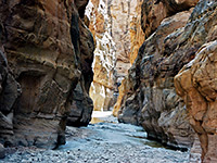
The Gulch has some open, shallower sections, but averages less than 10 feet wide for most of its length. There are always some residual pools of water and mud; the extent depends on how recently the canyon has flooded. Occasionally swimming will be necessary but normally the pools are just 2-3 feet deep and a few yards long.
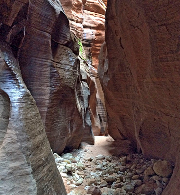
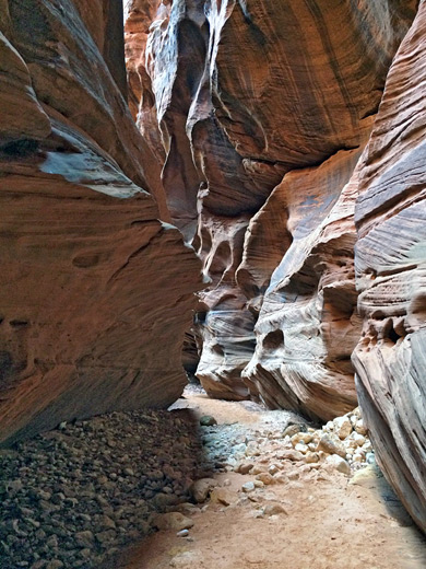
The water is permanently cold and muddy, and the canyon is certainly not a place to take expensive footwear. The walking surface is roughly half sand - sometimes hard and damp but mostly soft and dry - and half stones or boulders, so progress is more difficult than might be expected as the terrain is largely flat. There are some places where the floor drops a few feet but none of the sheer dryfalls found in some other slot canyons.
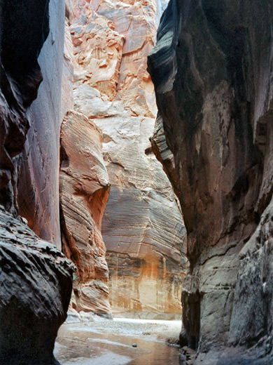
The only possible problem is a pile of boulders, 1.5 miles from the end of the gulch, where the floor drops down by about 20 feet. A rope may be useful (and one is often left in place) but most people manage to climb down between the rocks. Each flood has the potential to make significant changes to the canyon, though, so these boulders may be more of an obstruction on some occasions. There is no drinkable water except for a clear, shallow stream that flows for the last half mile before the confluence with the Paria River.
The junction is a magical place, with a overpowering sense of isolation and adventure. The water of the Paria river is fast-flowing and light-brown colored, quite different to the clear lazy flow down the Gulch. There are some sandbanks but generally the river covers all of the canyon floor. The Paria is narrow for about 2 miles in each direction; downstream the gorge becomes wider although still impressive, and eventually joins the Colorado at Lees Ferry. There are plenty of possible camp sites, and several fresh water sources on the way.
The walls of both canyons are rather dark, and the great depth means that the sun rarely illuminates the narrow passages fully, and Buckskin lacks the pretty patterns of light and color as are found in, for example, Water Holes Canyon. Still, the walls of the gulch do show the characteristic swirls and curves worn by countless millennia of floods, and they are eroded into innumerable eerie rock formations which, given a vivid imagination and the right kind of light, can resemble all kinds of distorted creatures and strange objects.
Location
Buckskin Gulch (named on some maps as Kaibab Gulch, or The Dive) is a tributary of the Paria River that drains an area around the Vermilion Cliffs in far south Utah and joins the Paria exactly at the Utah/Arizona border, 20 miles from Lees Ferry next to the Colorado River.
Buckskin Gulch Canyoneering Tours

Buckskin Gulch Trailheads
Three trailheads give access to the gulch; Middle, Wire Pass and Buckskin. The Middle Trail leads to the canyon about half way, but involves a 5 mile trip on bad roads and a climb down the cliff walls. The other two entry points are more popular, and are both reached along a reasonable quality dirt track - fine for 2WD cars - that heads due south from US 89 near milepost 26, 4 miles east of the turn off to the Paria ghost town. After 4.5 miles, a signpost points to the Buckskin Trailhead, where the gulch is unremarkable - wide and meandering, filled with soft sand, and remains similar in appearance for several miles downstream. Most people prefer the Wire Pass Trailhead, 4 miles further south since it affords quicker access to the deep, scenic parts of the canyon. Only about 2 miles of the narrows are by-passed, and the start of the route is along the Wire Pass side canyon that is also quite narrow and interesting.
 Buckskin Gulch Trailheads |


Permits for Buckskin Gulch
Buckskin Gulch is popular, potentially hazardous and part of the Paria Canyon - Vermilion Cliffs Wilderness, so there are several rules regarding access. A fee is required for all visits (see www.blm.gov) for details. Day use (2024) is $6 per person, camping an additional $5 per person; overnight trips must be booked in advance and are restricted to 20 people per night, though this limit is rarely reached.
Photographs
34 views of Buckskin Gulch.
Canyon Route
A detailed Buckskin Gulch trip report.
Buckskin Gulch Route Description
The Gulch has some open, shallower sections, but averages less than 10 feet wide for most of its length. There are always some residual pools of water and mud; the extent depends on how recently the canyon has flooded. Occasionally swimming will be necessary but normally the pools are just 2-3 feet deep and a few yards long.
The water is permanently cold and muddy, and the canyon is certainly not a place to take expensive footwear. The walking surface is roughly half sand - sometimes hard and damp but mostly soft and dry - and half stones or boulders, so progress is more difficult than might be expected as the terrain is largely flat. There are some places where the floor drops a few feet but none of the sheer dryfalls found in some other slot canyons.
Boulders near the Paria Confluence
The only possible problem is a pile of boulders, 1.5 miles from the end of the gulch, where the floor drops down by about 20 feet. A rope may be useful (and one is often left in place) but most people manage to climb down between the rocks. Each flood has the potential to make significant changes to the canyon, though, so these boulders may be more of an obstruction on some occasions. There is no drinkable water except for a clear, shallow stream that flows for the last half mile before the confluence with the Paria River.
The Paria River
The junction is a magical place, with a overpowering sense of isolation and adventure. The water of the Paria river is fast-flowing and light-brown colored, quite different to the clear lazy flow down the Gulch. There are some sandbanks but generally the river covers all of the canyon floor. The Paria is narrow for about 2 miles in each direction; downstream the gorge becomes wider although still impressive, and eventually joins the Colorado at Lees Ferry. There are plenty of possible camp sites, and several fresh water sources on the way.

Buckskin Gulch is one of the top 25 slot canyons
Buckskin Gulch - Similar Hikes
All Contents © Copyright The American Southwest | Comments and Questions | Contribute | Affiliate Marketing Disclosure | Site Map