The southwest quarter of Arizona contains just one NPS preserve (Organ Pipe Cactus National Monument), and elsewhere in the desert there are few maintained trails. Some other recognized hiking locations are Agua Fria National Monument, Lake Pleasant and South Mountain Park.
Map shows trailhead locations
1. Alamo Canyon Trail, Organ Pipe Cactus National Monument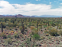 Length 1.3 miles (2.1 km) Elevation change 130 feet (40 meters) Difficulty Easy Rating (1-5) ★★★★★ Well used path alongside a seasonal wash, passing cottonwood trees and plenty of cacti, to the remains of an old ranch building. After about one mile the trail becomes less clearly defined, and merges with the rather overgrown dry streambed. Better views can be obtained by climbing up the valley sides a way. |
2. Arch Canyon Trail, Organ Pipe Cactus National Monument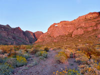 Length 1.3 miles (2.1 km); including the continuation Elevation change 1100 feet (335 meters) Difficulty Easy, moderate Rating (1-5) ★★★★★ Short path into the mouth of a wide canyon containing an arch. A lesser trail climbs far above the valley floor, high into the Ajo Mountains, giving good views of rock formations and the desert below. |
3. Badger Springs Canyon and the Agua Fria River, Agua Fria National Monument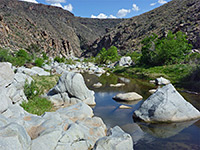 Length 0.8 miles (1.3 km); to the river - continuation hikes possible Elevation change 100 feet (30 meters) Difficulty Easy Rating (1-5) ★★★★★ A short trail down Badger Springs Wash, which joins the Agua Fria River in a deepening canyon whose walls are home to many and varied cacti. Petroglyphs may be found in scattered locations and the canyon is also a likely location to spot wildlife. Continuation hikes up or down the canyon are easy, except perhaps during the high water period of spring. |
4. Baker Mine Trail, Organ Pipe Cactus National Monument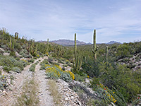 Length 2.6 miles (4.2 km); trail continues 1.4 miles to another mine (Milton) Elevation change 100 feet (30 meters) Difficulty Easy, at cooler times of the year Rating (1-5) ★★★★★ Seldom hiked route along an old vehicle track, across fairly level terrain of small hills and stony dry washes, all densely covered with cacti and other Sonoran Desert plants, to the site of an abandoned gold mine. |
5. Bill William River Canyon, Bill Williams River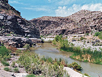 Length 1.7 miles (2.7 km); to the first narrows Elevation change 200 feet (61 meters) Difficulty Moderate Rating (1-5) ★★★★★ Narrow, desert canyon in a remote part of the state, accessible at the upper end from the paved road to Alamo Lake State Park. Hike follows a road then a trail alongside the river, ending at a narrows section. Continuing further downstream is possible, via a combination of wading and climbing. |
6. Bull Pasture/Estes Canyon, Organ Pipe Cactus National Monument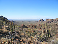 Length 3.5 miles (5.6 km); (loop) Elevation change 1050 feet (320 meters) Difficulty Somewhat strenuous due to elevation change, but relatively short Rating (1-5) ★★★★★ Interesting loop path that climbs into the Ajo Mountain foothills, up a ridge and down a valley, passing numerous species of cacti and other desert plants, and a variety of landscapes. Views from the end point extend for over 20 miles across the flat Sonoyta Valley into Mexico, and for a similar distance west to the Puerto Blanco Mountains |
7. Desert View Trail, Organ Pipe Cactus National Monument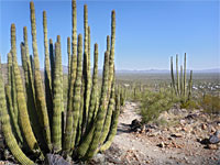 Length 1.2 miles (1.9 km); loop Elevation change 170 feet (52 meters) Difficulty Easy Rating (1-5) ★★★★★ Loop across a stony hillside near the park campground, covered with many and varied desert plants; good views of the flat plains to the south |
8. Ford Canyon and Mesquite Canyon Trails, White Tank Mountain Regional Park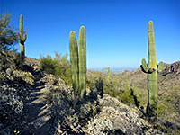 Length 9.6 miles (15.4 km) Elevation change 1400 feet (427 meters) Difficulty Moderate Rating (1-5) ★★★★★ Varied loop along several canyons and intervening ridges, from cactus lowlands to grassy hills near the mountain crest; also involves the Waddell and Willow Canyon trails. Encounters many species of wildflowers and cacti. |
9. Goldmine, Dynamite and Moonlight Trails, San Tan Mountain Regional Park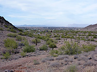 Length 7.5 miles (12.1 km); round trip Elevation change 500 feet (152 meters) Difficulty Moderate Rating (1-5) ★★★★★ Varied loop across mountains, ravines and plains, also involving part of the San Tan Trail; good views in all directions, and plentiful cacti in some areas |
10. Hidden Valley Trail, South Mountain Park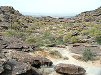 Length 3.5 miles (5.6 km); (loop) Elevation change 400 feet (122 meters) Difficulty Easy Rating (1-5) ★★★★★ Perhaps the best short hike in South Mountain Park, from the Buena Vista lookout point eastwards along the mountain crest - across sandy, undulating ground to a sheltered, cactus-filled basin. Good views over the west Phoenix suburbs. |
11. Palm Canyon, Kofa National Wildlife Refuge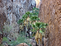 Length 0.5 miles (0.8 km); to the viewpoint; about 1 mile to the head of the canyon Elevation change 300 feet (91 meters) Difficulty Easy Rating (1-5) ★★★★★ Palm Canyon is the most visited location within Kofa NWR as it is the last place in the state where native California palm trees grow in their natural habitat. A short path - steep and uneven in places but not at all difficult - leads along the canyon to a viewpoint below the trees. Off trail continuation hikes are possible, across to the palms and further up the main canyon. |
12. Pinkley Peak, Organ Pipe Cactus National Monument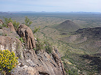 Length 1.3 miles (2.1 km) Elevation change 1220 feet (372 meters) Difficulty Moderate Rating (1-5) ★★★★★ Highest peak in the Puerto Blanco Mountains, reachable by an off-trail hike - along a shallow drainage to a rocky bowl, then up steepening slopes to the jagged summit. Many cacti and spring wildflowers; fantastic views from the summit. |
13. Pipeline Canyon Trail, Lake Pleasant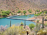 Length 1.8 miles (2.9 km) Elevation change 220 feet (67 meters) Difficulty Easy Rating (1-5) ★★★★★ The trail crosses pristine, undeveloped desert land along the west side of Lake Pleasant, mostly out of sight of the water apart from in the middle, where it descends to cross a narrow inlet (Pipeline Cove), via a floating metal bridge (not in use if water levels are low). The remainder of the trail is alongside dry washes, with minimal elevation change. |
14. Red Tanks Tinaja and Senita Basin, Organ Pipe Cactus National Monument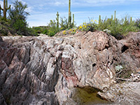 Length 3.2 miles (5.1 km) Elevation change 260 feet (79 meters) Difficulty Easy, at cooler times of the year Rating (1-5) ★★★★★ Trail from Puerto Blanco Drive, south over flattish land to the seasonal pools of Red Tanks Tinaja, then along a wash into Senita Basin, home to the rare pachycereus schottii cactus. The elevation change is minimal, and the scenery somewhat varied, changing from an open plain in the north, over a low ridge to the enclosed wash downstream of the Tinaja - beneath low summits of the mountains, and the more densely vegetated land of the basin. |
15. Twin Peaks, Organ Pipe Cactus National Monument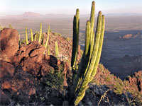 Length 0.9 miles (1.4 km) Elevation change 900 feet (274 meters) Difficulty Moderate to strenuous Rating (1-5) ★★★★★ Prominent, 2,615 foot summit at the east edge of the Puerto Blanco Mountains, with two closely-spaced high points, reachable by a short but steep, off-trail hike |
16. Victoria Mine Trail, Organ Pipe Cactus National Monument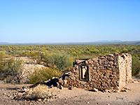 Length 2.2 miles (3.5 km) Elevation change 100 feet (30 meters) Difficulty Easy Rating (1-5) ★★★★★ Fairly level route over dry washes and undulating, cactus-covered hills to the site of a 19th century gold and silver mine, where various relics can be seen including iron equipment, stone cabins and tailings piles. Good, long distance views along the way. Victoria Mine is listed on the National Register of Historic Places, as one of the oldest prospecting sites in southwest Arizona |
17. Wind Cave Trail, Usery Mountain Regional Park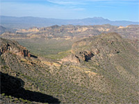 Length miles ( km) Elevation change feet ( meters) Difficulty Rating (1-5) ★★★★★ Small park with good facilities, containing several square miles of Sonoran Desert flats and hills, crossed by many trails, two of which continue into the higher ground of Pass Mountain to the east; most popular is the Wind Cave Trail |
All Contents © Copyright The American Southwest | Comments and Questions | Contribute | Affiliate Marketing Disclosure | Site Map