Twin Peaks, Organ Pipe Cactus National Monument
Arizona > Organ Pipe Cactus National Monument > Twin Peaks
Twin Peaks
Prominent, 2,615 foot summit at the east edge of the Puerto Blanco Mountains, with two closely-spaced high points, reachable by a short but steep, off-trail hike
Length: 0.9 miles
Elevation change: 900 feet
Difficulty: Moderate to strenuous
Type: One way, off trail
Usage: Low
Season: Fall, winter, spring; very hot in summer
Trailhead: 0.8 miles along Puerto Blanco Drive
Rating (1-5): ★★★★★
Elevation change: 900 feet
Difficulty: Moderate to strenuous
Type: One way, off trail
Usage: Low
Season: Fall, winter, spring; very hot in summer
Trailhead: 0.8 miles along Puerto Blanco Drive
Rating (1-5): ★★★★★

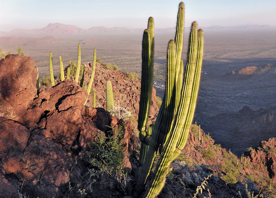
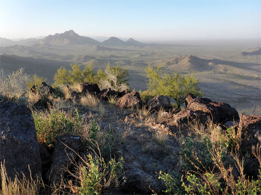
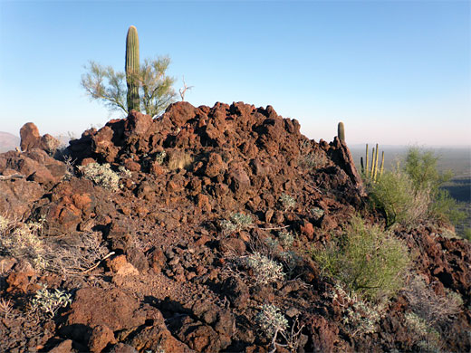
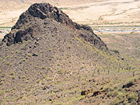
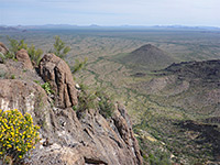
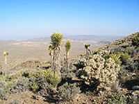
The Puerto Blanco Mountains extend ten miles across the south-central portion of Organ Pipe Cactus National Monument, on the west side of Hwy 85, and are formed of reddish volcanic rocks from the Jurassic period, including rhyolitic tuff, lava and conglomerate. The mountains consist of two lines of parallel ridges, with the highest point in the northern section, 3,145 foot Pinkley Peak, while the tallest summit in the southern section, right at its eastern end, is Twin Peaks, 2,615 feet, so-named because of its pair of high points, 300 feet apart.
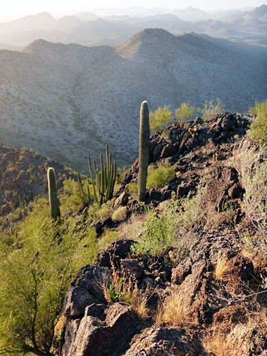
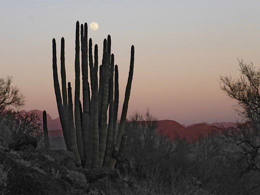
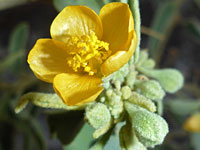
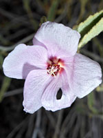
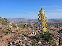
Like Pinkley Peak, or indeed anywhere in the mountains, there is no trail to the summits of Twin Peaks, though they can be reached by a moderately strenuous, off-trail hike of just less than a mile, gaining 900 feet. Because the peaks are isolated, higher than all their surroundings, the views from the upper reaches are spectacular, and the rocky slopes have a good selection of wildflowers and cacti, including a scattering of saguaro and organ pipes. The colors of the rocks are especially rich around sunset.
Organ Pipe Cactus National Monument map.
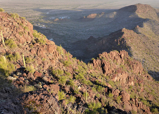
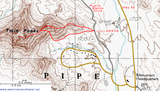
A suitable parking place, on the east side of the peak, is at an interpretive pull-out along Puerto Blanco Drive, 0.8 miles from the highway intersection, and just beyond an NPS residential area, below the south face of the mountain. The summit can be reached by walking along the base of the ridge, either north or south, then up the slopes, or by following the ridgeline, up and down over some lesser prominences - the description below is via this route, then back via the southern slopes.
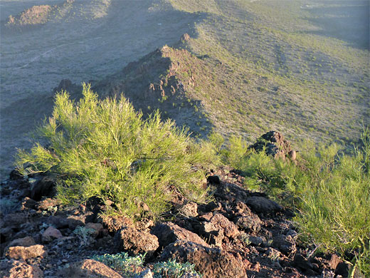
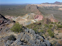
From Puerto Blanco Drive, the land rises fairly gently at the east end of the ridge, up over a tiny peak then a slightly taller one and then, after a dip, to a rather bigger summit which has a short cliff beyond, bypassed on the north side, followed by a steady ascent to the main summits, in another 0.4 miles. Apart from the cliff there are no particular obstacles beyond cacti and spiky bushes, though the surface is often covered with loose stones, making the footing rather unstable. The rocks are coarsely textured and weathered, generally good for climbing over; hands are needed in a few places. The ridgeline harbors many eroded cavities, some big enough to shelter in, and numerous smaller crevices; this looks to be ideal snake territory. The twin peaks are separated by a gully, and both are fairly flat on top, especially the northern one, the taller. The quickest route back is to descend the ridge eastwards for about a quarter of a mile, to a saddle, then drop down the steep slopes to the south and finally walk across the flat desert on the north side of the NPS residential area, to Puerto Blanco Road.
Like Pinkley Peak, or indeed anywhere in the mountains, there is no trail to the summits of Twin Peaks, though they can be reached by a moderately strenuous, off-trail hike of just less than a mile, gaining 900 feet. Because the peaks are isolated, higher than all their surroundings, the views from the upper reaches are spectacular, and the rocky slopes have a good selection of wildflowers and cacti, including a scattering of saguaro and organ pipes. The colors of the rocks are especially rich around sunset.
Location
Organ Pipe Cactus National Monument map.
Trailhead
A suitable parking place, on the east side of the peak, is at an interpretive pull-out along Puerto Blanco Drive, 0.8 miles from the highway intersection, and just beyond an NPS residential area, below the south face of the mountain. The summit can be reached by walking along the base of the ridge, either north or south, then up the slopes, or by following the ridgeline, up and down over some lesser prominences - the description below is via this route, then back via the southern slopes.
The Hike
From Puerto Blanco Drive, the land rises fairly gently at the east end of the ridge, up over a tiny peak then a slightly taller one and then, after a dip, to a rather bigger summit which has a short cliff beyond, bypassed on the north side, followed by a steady ascent to the main summits, in another 0.4 miles. Apart from the cliff there are no particular obstacles beyond cacti and spiky bushes, though the surface is often covered with loose stones, making the footing rather unstable. The rocks are coarsely textured and weathered, generally good for climbing over; hands are needed in a few places. The ridgeline harbors many eroded cavities, some big enough to shelter in, and numerous smaller crevices; this looks to be ideal snake territory. The twin peaks are separated by a gully, and both are fairly flat on top, especially the northern one, the taller. The quickest route back is to descend the ridge eastwards for about a quarter of a mile, to a saddle, then drop down the steep slopes to the south and finally walk across the flat desert on the north side of the NPS residential area, to Puerto Blanco Road.
Topo Map of the Route
Twin Peaks - Similar Hikes
All Contents © Copyright The American Southwest | Comments and Questions | Contribute | Affiliate Marketing Disclosure | Site Map