The American Southwest
Home | Parks | Trails | Plants | Canyons
Maps | Landscapes | Site Map | Whats New? |
More...
Follow americansouthwest.net on Facebook
×
General Pages
Home
Parks
Trails
Plants
Slot Canyons
Maps
Landscapes
Itineraries
Site Map
What's New?
More pages...

States
Arizona
California
Colorado
Idaho
Nevada
New Mexico
Oregon
Texas
Utah
Wyoming


ARIZONA
CALIFORNIA
COLORADO
IDAHO
NEVADA
NEW MEXICO
OREGON
TEXAS
UTAH
WYOMING

Travelogue

INDEX | MAPS

Week 3 - Corpus Christi to El Paso; Carlsbad Caverns and El Paso

Calendar
S M T W T F S
June 22 23 24 25
26 27 28 29 30 1 2
3 4 5 6 7 8 9
10 11 12 13 14 15 16
17 18 July


Tuesday 12 July 1994: We were rudely awakened at 6 am by a timid old man knocking on our door. Luckily he was not persistent and went away. Maybe we were on private land, but there was no indication of this. Of course, he may have been in desperate need of help, or offering free lottery tickets, but we shall never know. Still, we packed up quickly and left nonetheless, driving along an empty ranch road which joined the main US 180 south west of Carlsbad. A little further south was Whites City, turn-off for the world-famous Carlsbad Caverns. The town itself is best not visited; fake old-western buildings with lots of souvenir shops and caravan parks, but a pretty, winding road led up into the hills to the cavern entrance. A huge visitor center with every conceivable facility was full of hundreds of people, many awaiting the regular guided tours around the caves. We elected for the longer of the two unsupervised routes (the 'Blue Loop Trail'), which was supposed to take three hours, but even after frequent stops (for attempted photos), and despite the best efforts of many slow-moving Americans to inhibit our progress, it took only 1 hour 20 minutes.

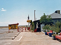
The cave itself was undeniably spectacular, with many amazing spaeleotherms (formations). It's a pity everywhere is so commercialised, but I suppose there is no real alternative. The tour ended at an underground cafe, subject of much debate over its location - this sort of thing should be kept above ground I think. A lift returned us to ground level 750 feet up (taking only 1 minute), and back to the midday heat. Next we rejoined US 180, went past an impressive hilly area next to the Guadalupe Mountains National Park and had lunch at Salt Flat, which was like a mini version of the Great Salt Lake Desert in Utah. The temperature was 118 in the sun. After lunch the very straight road continued through completely empty lands. We passed a sign saying 'No gas for 80 miles', calculating that we could just make it. Eighty miles later we arrived at Cornudas, which was 'Closed on Tuesdays', according to a helpful sign. Luckily just a few miles before this there was a jovial bar/motel with one petrol pump, where we filled up (at $2 a gallon!).

photograph
Cornudas on tuesday
photograph
Friendly mailboxes

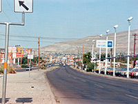
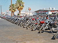
Another hour of driving brought us back to El Paso. It was strange as we approached the city to see the very gradual signs of civilisation returning; first a few isolated houses then more gas stations and building sites where new industrial sites were appearing, as the city grew into the surrounding desert. Just the reverse of I-10 as we left El Paso the previous week. On the approach road there is the world's largest Harley Davidson dealer. We returned to the same RV site as before ("The Roadrunner"), and had dinner in the same Mexican restaurant (Julio's).

photograph
Approaching El Paso
photograph
The world's biggest Harley dealer

Map | Next Day

Arizona | California | Colorado | Idaho | Nevada | New Mexico | Oregon | Texas | Utah | Wyoming | Slot Canyons | Travelogue | SOUTHWEST

All Contents © Copyright The American Southwest | Comments and Questions | Contribute | Affiliate Marketing Disclosure | Site Map