Week 1 - Phoenix to Gallup; The Grand Canyon
Saturday 25 June 1994: We tried to get up early enough to enter the
Grand Canyon National Park
without paying, but were just
too late, arriving at the entrance point just after 8 am. The approach road seemed to go
on a long time, but eventually we arrived. I had been here the year before, but still the
sight was awesome. Yavapai Point was our first viewpoint, along with a coachload of
elderly Americans who had managed to walk the few yards from their transport to the
edge of the abyss, but were keen to get back to their coach for a rest. We progressed
westwards along the perimeter road, parked near the railway terminus, picked up
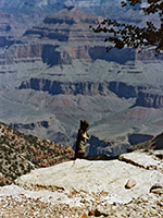
more water supplies from a handy public tap and went to the
Bright Angel trailhead, where a chipmunk
conveniently posed for a photo. Strolled past the signs warning of heat exposure and
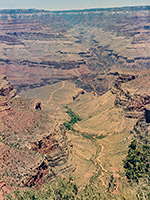
death, laughing at all the exhausted climbers struggling back up, and began the
journey down. After 2 hours, we had passed Rest Station 1 and the temperature had
risen at least 10 degrees since the top, so it was time to return - this took at least 3
hours and was much harder than we expected. The Lodge at the bottom of the canyon
recorded 115 °F that day.
A more relaxing way to see the Canyon is to take the free shuttle buses; the West
Rim bus, which travels on a road closed to public traffic, takes about 30 min to reach
the farthest point west of the main road, Hermits Rest. We
alighted the stop before (Pina Point) and had a pleasant, flat 1 mile walk through to
the end, arriving to be congratulated by onlookers on our achievement, which was
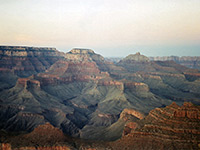
nothing! In the evening, we watched the sunset at a place on the East Rim drive with
999 American tourists, one of whom insisted on talking to us about English beer.
|