The American Southwest
Home | Parks | Trails | Plants | Canyons
Maps | Landscapes | Site Map | Whats New? |
More...
Follow americansouthwest.net on Facebook
×
General Pages
Home
Parks
Trails
Plants
Slot Canyons
Maps
Landscapes
Itineraries
Site Map
What's New?
More pages...

States
Arizona
California
Colorado
Idaho
Nevada
New Mexico
Oregon
Texas
Utah
Wyoming


ARIZONA
CALIFORNIA
COLORADO
IDAHO
NEVADA
NEW MEXICO
OREGON
TEXAS
UTAH
WYOMING

Travelogue

INDEX | MAPS

Week 1 - Phoenix to Gallup; Montezuma and Tuzigoot

Calendar
S M T W T F S
June 22 23 24 25
26 27 28 29 30 1 2
3 4 5 6 7 8 9
10 11 12 13 14 15 16
17 18 July


Thursday 23 June 1994: A brief walk to the lake was rewarded by the sight of one heron and several jumping fish. Continuing north on AZ 188, the terrain changed quite quickly from the relatively barren cacti country (which was still very striking) to thick fir and pine forests around Payson. Roads 260 and 87 and led us to the Indian cliff dwelling of Montezuma Castle National Monument, one of those places I had seen before in photos, but never known where it was. Its really impressive, especially the scale of it (five storeys), but climbing up is not allowed, so after looking for a few minutes, there is not much else to do. Naturally, the place is commercialised; entry is through the obligatory gift shop. However, there is quite a good small museum as well, with specimens of preserved insects, Indian relics and geology.

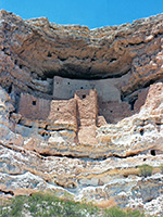
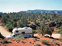
After getting temporarily lost in Campe Verde (a very sleepy Indian village, where the roads soon turned into dirt tracks), we came to Montezuma Well, actually a collapsed flooded limestone cavern, which was free. Saw some turtles and a tame squirrel but not much else. Apparently the 'well' is really deep (over 100 feet?), but swimming isn't allowed. On the other side of I-17, the town of Jerome was reputedly a well-preserved mining town with the distinction of having mainly wooden houses which were built on stilts. I found it a bit disappointing - lots of souvenir shops selling 'Indian' artefacts and expensive ear-rings, and I couldn't see any stilts. Still, the view acrosss the valley below was good. We passed the Tuzigoot National Monument (more ancient dwellings) on US 89A without paying a visit and turned off towards Red Rock, probably one of at least 100 places with such a name. After a mile or two, the road became a rocky track to Nowhere, but we managed to find a parking place for the night, with an uninterrupted view of the red hills around. Surprisingly, several other cars did go by - must have been some party somewhere, but nobody seemed to mind we that were camping there.

photograph
Montezuma Castle
photograph
Near Red Rock

Map | Next Day

Arizona | California | Colorado | Idaho | Nevada | New Mexico | Oregon | Texas | Utah | Wyoming | Slot Canyons | Travelogue | SOUTHWEST

All Contents © Copyright The American Southwest | Comments and Questions | Contribute | Affiliate Marketing Disclosure | Site Map