The American Southwest
Home | Parks | Trails | Plants | Canyons
Maps | Landscapes | Site Map | Whats New? |
More...
Follow americansouthwest.net on Facebook
×
General Pages
Home
Parks
Trails
Plants
Slot Canyons
Maps
Landscapes
Itineraries
Site Map
What's New?
More pages...

States
Arizona
California
Colorado
Idaho
Nevada
New Mexico
Oregon
Texas
Utah
Wyoming


ARIZONA
CALIFORNIA
COLORADO
IDAHO
NEVADA
NEW MEXICO
OREGON
TEXAS
UTAH
WYOMING

Travelogue

INDEX | MAPS

Week 1 - Phoenix to Gallup; Sedona and Flagstaff

Calendar
S M T W T F S
June 22 23 24 25
26 27 28 29 30 1 2
3 4 5 6 7 8 9
10 11 12 13 14 15 16
17 18 July


Friday 24 June 1994: We woke up at 5.30, not having completely adjusted to American time, but woken by the sound of someone jogging past. Continued north to Sedona, beyond which the valley became dramatically narrower as we entered Oak Creek Canyon - very scenic. Near the head of the canyon, on the left, is Slide Rocks Recreation area (not free), where Oak Creek flows down a series of smooth rocks with some deep pools, which is ideal for swimming and, of course, sliding, in the water. A good place if you don't mind sharing with thousands of other noisy people. If possible, climb up the canyon walls a bit - after 100 meters or so there is a flat area with magnificent views of the Creek (and people) below. I didn't see any black bears though. Road 89A twists and turns up at the end of the canyon, and our vehicle was reduced to 15 mph in some parts. Luckily there are some passing points At the top there is a viewpoint of the road down, which is probably more spectacular if first seen when travelling south; the road between here and Flagstaff is relatively flat and tree-lined.

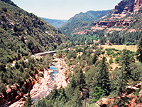
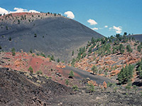
Flagstaff, Arizona is seen (in England at least) as being an archetypal distant, desert town far from anywhere, which one will never visit. So it was good to pass through, even though it seemed a perfectly normal place, although with a railway which divides the town in half and quite a few one-way streets, making navigation rather difficult. As with many towns in these parts, there are high mountains as a backdrop to the buildings, which looks quite spectacular. Before driving to the Grand Canyon, we visited Sunset Crater Volcano National Monument, about ten miles NE. This was a real contrast to the surroundings, with great expanses of black twisted lava flow, and the cone of the an volcano rising above. A signposted half hour walk passes identified various features of interest around the foot of the volcano, including the Ice Cave. This apparently remains below zero all year, and the air coming from it certainly seemed very cold, in contrast to the 100 degrees outside. At the time, entry to the cave was not permitted. A little further along the road, there was a view of the Painted Desert in the distance, but we turned back before Wupatki National Monument (lots of ruins), went through Flagstaff again at Rush hour (listening to the Limbaugh show), and then north on US 180, through Alpine-like meadows and forests of Ponderosa and Maripose pine. Parked at the Grand Canyon RV site, too late for sunset over the canyon, but in time for a meal at Denny's.

photograph
Slide rocks
photograph
Sunset Crater

Map | Next Day

Arizona | California | Colorado | Idaho | Nevada | New Mexico | Oregon | Texas | Utah | Wyoming | Slot Canyons | Travelogue | SOUTHWEST

All Contents © Copyright The American Southwest | Comments and Questions | Contribute | Affiliate Marketing Disclosure | Site Map