Bishop Pass Trail, Eastern Sierra
Spectacular trail past six lakes and many Alpine meadows to an 11,972 foot mountain pass near Mt Agassiz, continuing into Dusy Basin in Kings Canyon National Park. Particularly good for wildflowers in the summer
Length: 6 miles, to the pass, 7.5 miles to Dusy Basin
Elevation change: 2,150 feet
Difficulty: Moderate, becoming more strenuous around the pass
Type: One-way
Usage: Medium
Season: Early summer to early fall
Trailhead: End of the road to South Lake
Rating (1-5): ★★★★★
Elevation change: 2,150 feet
Difficulty: Moderate, becoming more strenuous around the pass
Type: One-way
Usage: Medium
Season: Early summer to early fall
Trailhead: End of the road to South Lake
Rating (1-5): ★★★★★

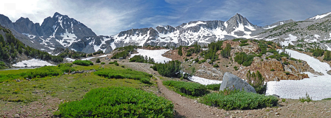
The six mile trail to Bishop Pass offers fantastic views nearly all the way, encountering six lakes together with many ponds, streams and floral meadows, and ending by traversing a rocky slope above the final lake (Bishop) and climbing steeply to a saddle along the Sierra Crest at 11,972 feet, below the west face of Mt Agassiz. Most of the hike is within the John Muir Wilderness, while beyond the pass, the trail crosses into Kings Canyon National Park, descending into Dusy Basin, perhaps even more spectacular; the lakes here are reached after another 1.5 miles, so are also within reach of a long day hike, though most people visiting the basin camp for at least one night.
The pass, one of at least 21 in the Sierra Nevada between Mt Whitney and Hwy 120, lies at the center of the longest section of the mountain crest between adjacent passes - 16 miles north to Piute and 15 miles south to Taboose. The hike begins at South Lake, reached by a paved road off Hwy 168 (22 miles from Bishop), so the easy access, the relatively gentle elevation gain (2,150 feet, steep only at the end) and the route to the Kings Canyon backcountry together with the incredible scenery make the route often relatively busy, though not to the same extent as similar routes in the Sierra national parks.
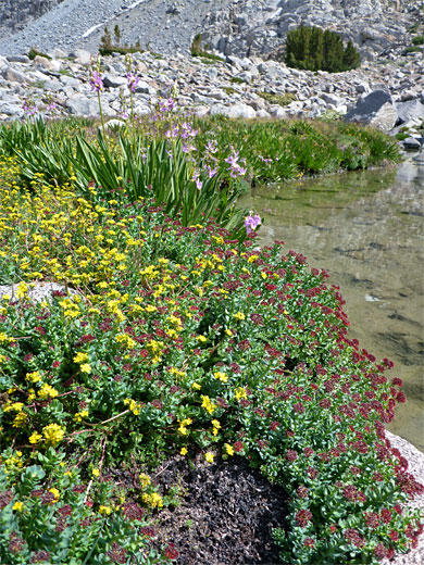
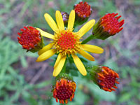
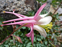
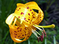
The full distance to the pass is usually accessible to regular hikers between June and October, and there are no major stream crossings or other obstacles; mosquitoes are perhaps the only problem, in midsummer. Wildflowers are particularly abundant, in meadows, across the talus slopes, beside streams and in woodland clearings, with many dozen species in view along the route.
58 views along the Bishop Pass Trail
Bishop Pass Trail topo map. Overview map of the Eastern Sierra
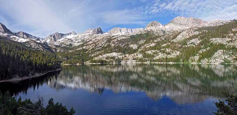
Start point for the Bishop Pass Trail is right at the end of South Lake Road, elevation 9,830 feet, at a parking lot accommodating around 70 vehicles, with more spaces a little way back. This location is on a wooded ridge overlooking South Lake, a reservoir formed in 1911 by construction of Hillside Dam across the South Fork of Bishop Creek; the biggest of six named lakes along the trail, extending over one mile along a steep-sided, tree-lined valley. There are no other facilities nearby apart from a boat ramp, though along the road are several campgrounds, a lodge and an RV park. For free camping the nearest places seem to be around 12 miles away along the lower reaches of Hwy 168, near Sand Canyon.
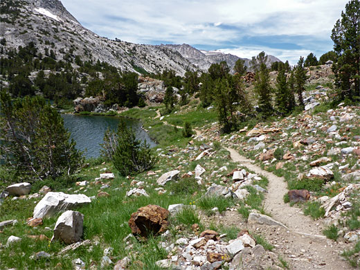
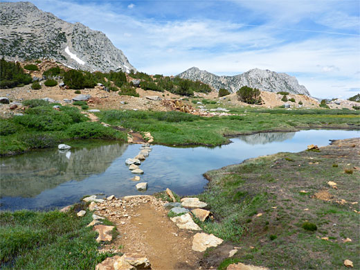
The trail encounters varied wildflowers right from the start, as it passes through a boggy area with a stream - notable species include kelley's lily, crimson columbine and white bog orchid. The ground soon becomes drier and mostly treeless, as the path runs down a little valley below a rocky hill, coming briefly close to the lake before starting to climb, with a longish straight followed by two stream crossings as the aspen and pines return, and a sign marking the boundary of the John Muir Wilderness, soon followed by another notice at a junction with a less-traveled route to the Treasure Lakes. The Bishops Pass Trail is then briefly flat, winding through a marshy area crossed by a pretty stream lined by many more wildflowers, later transitioning to dry woodland though with other meadows close by. Another creek crossing, and numerous orchids, is followed by a set of gentle, rocky switchbacks, the lake now 1,000 feet below. The trail continues across a minor saddle and into a little valley, where another junction is with a route to Bull Lake and the Chocolate Lakes.
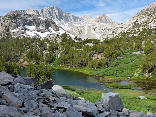
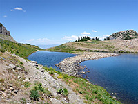
The path climbs the valley, dotted with a few isolated trees, to a picturesque, boggy flat, another good wildflower location including three species of orchid. Once over a stream, flowing from a shallow pond, Long Lake comes into view, initially its narrow northern inlet then the main body of water, which is half a mile in length, with Hurd Peak to the west and the jagged summits along the Sierra crest now clearly visible ahead. The path stays close to the shoreline for a while before moving away along a little ravine, past a junction with a trail to Ruwau Lake, and on to the Chocolate Lakes, where it links with the other trail, forming a loop.
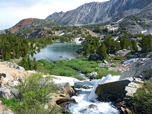
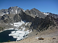
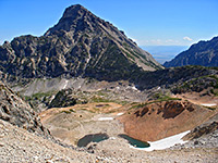
The trail returns to the water's edge at the south end of Long Lake, crossing one of the two entry streams (from Ruwau Lake) and starting the climb of a scree-covered slope, first running just below a little wooded knoll; a popular camping location, equipped with bear-proof lockers. The third lake, Spearhead is visible below, while ahead is a big wall of rock, below the rim of the upper Bishop Creek basin. After a steady ascent over the talus, the path reaches the basin rim and follows the shore of the westernmost of the two Timberline Tarns, along its entry stream, which forms a pretty cascade at one point, and up to the edge of Saddlerock Lake, scenically situated below a steep ridge leading to 13,085 foot Mount Goode.
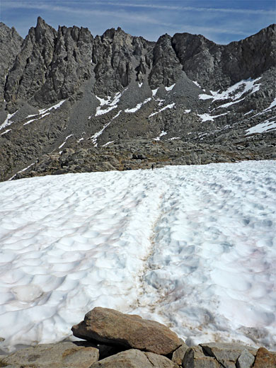
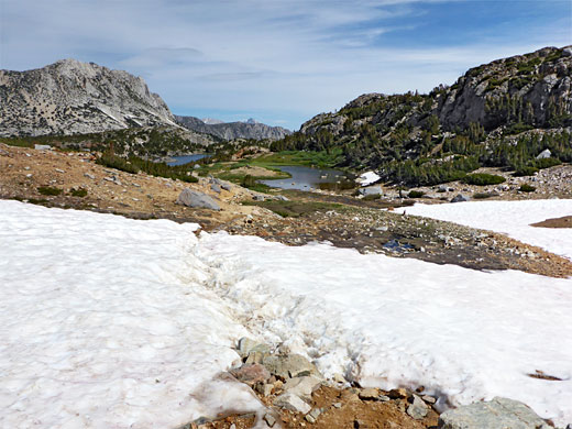
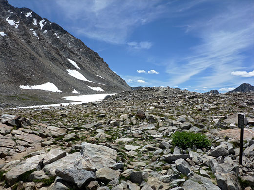
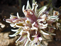
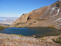
All-around are gaunt, grey, granite ridges and summits; talus or bare rock, partly or entirely snow-covered. The floor of the basin has a mix of gravel, earth, bogs and short-grass meadows, home to small-flowered plant species such as cushion buckwheat, cutleaf daisy, king's matted sandwort and southern sierra pincushion. The sixth lake, Bishop, is not far beyond Saddlerock, and has two main components separated by a narrow channel, with other pools close by. The trail enters the uppermost section of the basin, winding through some brownish mounds topped by stunted trees, climbing via several switchbacks into an area of generally bigger boulders and virtually no vegetation apart from along the edges of a few shallow ponds.
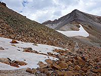
Ahead the ground slopes up precipitously by 500 feet, and the well-constructed trail rises via many stone steps, following a gully then directly up the hillside, towards the pass. The gradient lessens shortly before the top, the color of the granite bedrock briefly changing to reddish-brown. Ahead is a broad, boulder-strewn plateau where some snow remains all year, flanked by a narrow ridge to the west and the slopes of Mount Agassiz to the east. Cairns indicate the route, to the actual high point, where a sign marks the Kings Canyon National Park boundary.
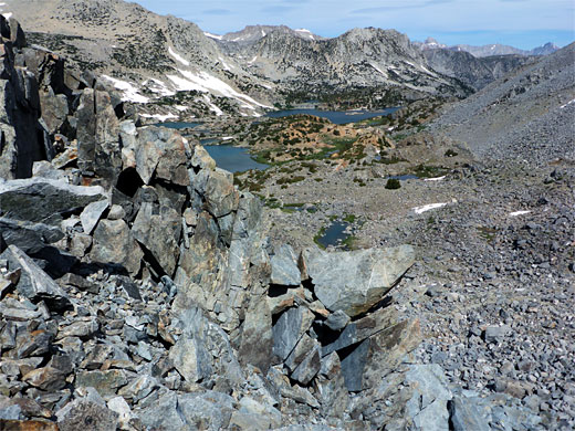
From the pass, the trail drops into a shallow ravine, and soon rounds a corner, giving the first views of Dusy Basin, 600 feet below. A short spur leads to a fine overlook on a granite promontory, just before a steeper descent - still more gentle than the climb on the other side of the pass - over mostly rocky terrain, to a circular pool at the north edge of the basin; other lakes are reachable by cross-country walks of up to one mile. The path continues 6 miles to the Le Conte Ranger Station along the John Muir Trail, still deep in the Kings Canyon backcountry.
The pass, one of at least 21 in the Sierra Nevada between Mt Whitney and Hwy 120, lies at the center of the longest section of the mountain crest between adjacent passes - 16 miles north to Piute and 15 miles south to Taboose. The hike begins at South Lake, reached by a paved road off Hwy 168 (22 miles from Bishop), so the easy access, the relatively gentle elevation gain (2,150 feet, steep only at the end) and the route to the Kings Canyon backcountry together with the incredible scenery make the route often relatively busy, though not to the same extent as similar routes in the Sierra national parks.
The full distance to the pass is usually accessible to regular hikers between June and October, and there are no major stream crossings or other obstacles; mosquitoes are perhaps the only problem, in midsummer. Wildflowers are particularly abundant, in meadows, across the talus slopes, beside streams and in woodland clearings, with many dozen species in view along the route.

Photographs
58 views along the Bishop Pass Trail
Maps
Bishop Pass Trail topo map. Overview map of the Eastern Sierra
Bishop Pass Trailhead
Start point for the Bishop Pass Trail is right at the end of South Lake Road, elevation 9,830 feet, at a parking lot accommodating around 70 vehicles, with more spaces a little way back. This location is on a wooded ridge overlooking South Lake, a reservoir formed in 1911 by construction of Hillside Dam across the South Fork of Bishop Creek; the biggest of six named lakes along the trail, extending over one mile along a steep-sided, tree-lined valley. There are no other facilities nearby apart from a boat ramp, though along the road are several campgrounds, a lodge and an RV park. For free camping the nearest places seem to be around 12 miles away along the lower reaches of Hwy 168, near Sand Canyon.
South Lake to the Chocolate Lakes Junction
The trail encounters varied wildflowers right from the start, as it passes through a boggy area with a stream - notable species include kelley's lily, crimson columbine and white bog orchid. The ground soon becomes drier and mostly treeless, as the path runs down a little valley below a rocky hill, coming briefly close to the lake before starting to climb, with a longish straight followed by two stream crossings as the aspen and pines return, and a sign marking the boundary of the John Muir Wilderness, soon followed by another notice at a junction with a less-traveled route to the Treasure Lakes. The Bishops Pass Trail is then briefly flat, winding through a marshy area crossed by a pretty stream lined by many more wildflowers, later transitioning to dry woodland though with other meadows close by. Another creek crossing, and numerous orchids, is followed by a set of gentle, rocky switchbacks, the lake now 1,000 feet below. The trail continues across a minor saddle and into a little valley, where another junction is with a route to Bull Lake and the Chocolate Lakes.
Long Lake
The path climbs the valley, dotted with a few isolated trees, to a picturesque, boggy flat, another good wildflower location including three species of orchid. Once over a stream, flowing from a shallow pond, Long Lake comes into view, initially its narrow northern inlet then the main body of water, which is half a mile in length, with Hurd Peak to the west and the jagged summits along the Sierra crest now clearly visible ahead. The path stays close to the shoreline for a while before moving away along a little ravine, past a junction with a trail to Ruwau Lake, and on to the Chocolate Lakes, where it links with the other trail, forming a loop.

Spearhead Lake, Timberline Tarns and Saddlerock Lake
The trail returns to the water's edge at the south end of Long Lake, crossing one of the two entry streams (from Ruwau Lake) and starting the climb of a scree-covered slope, first running just below a little wooded knoll; a popular camping location, equipped with bear-proof lockers. The third lake, Spearhead is visible below, while ahead is a big wall of rock, below the rim of the upper Bishop Creek basin. After a steady ascent over the talus, the path reaches the basin rim and follows the shore of the westernmost of the two Timberline Tarns, along its entry stream, which forms a pretty cascade at one point, and up to the edge of Saddlerock Lake, scenically situated below a steep ridge leading to 13,085 foot Mount Goode.
Bishop Creek Basin
All-around are gaunt, grey, granite ridges and summits; talus or bare rock, partly or entirely snow-covered. The floor of the basin has a mix of gravel, earth, bogs and short-grass meadows, home to small-flowered plant species such as cushion buckwheat, cutleaf daisy, king's matted sandwort and southern sierra pincushion. The sixth lake, Bishop, is not far beyond Saddlerock, and has two main components separated by a narrow channel, with other pools close by. The trail enters the uppermost section of the basin, winding through some brownish mounds topped by stunted trees, climbing via several switchbacks into an area of generally bigger boulders and virtually no vegetation apart from along the edges of a few shallow ponds.
Ascent to Bishop Pass
Ahead the ground slopes up precipitously by 500 feet, and the well-constructed trail rises via many stone steps, following a gully then directly up the hillside, towards the pass. The gradient lessens shortly before the top, the color of the granite bedrock briefly changing to reddish-brown. Ahead is a broad, boulder-strewn plateau where some snow remains all year, flanked by a narrow ridge to the west and the slopes of Mount Agassiz to the east. Cairns indicate the route, to the actual high point, where a sign marks the Kings Canyon National Park boundary.
Dusy Basin
From the pass, the trail drops into a shallow ravine, and soon rounds a corner, giving the first views of Dusy Basin, 600 feet below. A short spur leads to a fine overlook on a granite promontory, just before a steeper descent - still more gentle than the climb on the other side of the pass - over mostly rocky terrain, to a circular pool at the north edge of the basin; other lakes are reachable by cross-country walks of up to one mile. The path continues 6 miles to the Le Conte Ranger Station along the John Muir Trail, still deep in the Kings Canyon backcountry.

Bishop Pass Trail - Similar Hikes
All Contents © Copyright The American Southwest | Comments and Questions | Contribute | Affiliate Marketing Disclosure | Site Map