Airport Loop Trail
#211
#211
Mostly shadeless loop path that circles the flat summit of Table Top Mountain, site of Sedona Airport; a little way below the rim, with spectacular, ever-changing views of the city and its red rock surroundings
Length: 3.2 miles, or 4.2 miles including the Table Top spur (round trip)
Elevation change: 150 feet
Difficulty: Easy
Type: Loop
Usage: Medium to high
Season: All year
Trailhead: Airport Road, or Sunset Park
Rating (1-5): ★★★★★
Elevation change: 150 feet
Difficulty: Easy
Type: Loop
Usage: Medium to high
Season: All year
Trailhead: Airport Road, or Sunset Park
Rating (1-5): ★★★★★

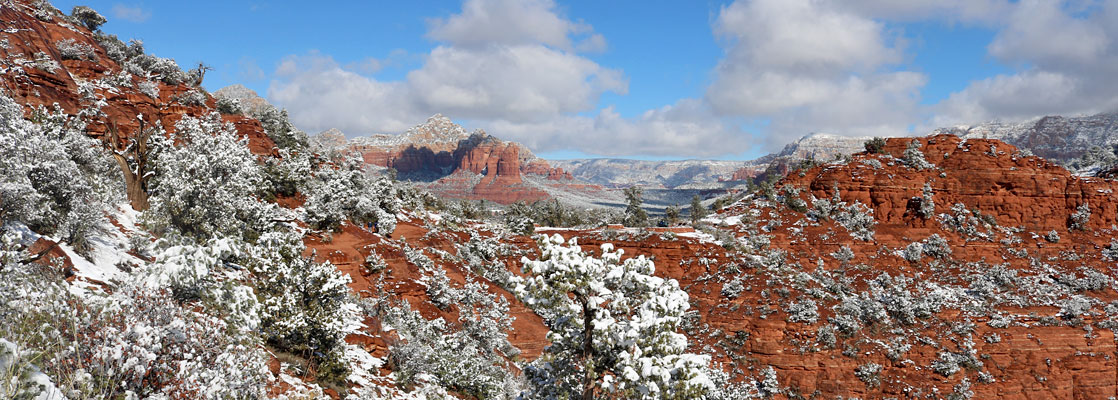
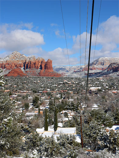
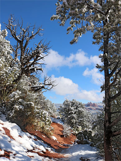
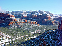
Sedona Airport was built in 1955, on the flat, 4,770 foot summit of Table Top Mountain on the south side of town, long enough for a one mile runway. The mountain is covered by gravel and basalt while the sides are all dark red sandstone from the Supai Formation, lightly wooded, the pinyon pines and junipers mixed with opuntia, yucca, agave and ocotillo, plus many species of wildflowers, through which runs the 3.2 mile Airport Loop Trail, #211.
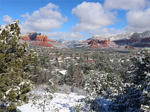
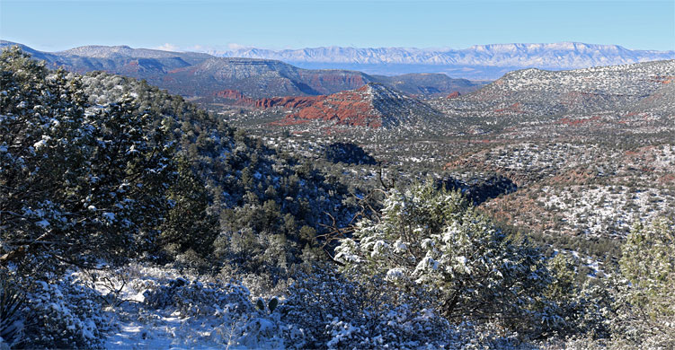
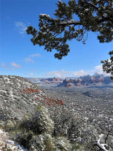
The path offers spectacular, ever-changing views all the way - there are no closer peaks to block the panoramas apart from a small butte to the north, so many of Sedona's landmarks can be seen, from the Dry Creek area in the northwest, across Capitol Butte, Soldier Pass and Wilson Mountain, east to Munds and Lee mountains, and south to Cathedral Rock. The airport itself is out-of-sight since the path mostly stays below the plateau rim, by between 100 and 200 feet. The trail is surprisingly peaceful and gives a sense of remoteness despite the suburbs being in view, as it is not near any main roads, and the airport receives only a small number of flights. The path can however be quite busy, even though visitor numbers are limited due to the small trailhead parking.
The loop is 3.2 miles in length, with only 150 feet of elevation change; it can be extended to include the 0.5 mile Table Top Trail (#212), a spur which follows an extension of the mesa to the southwest.
Sedona map.
37 views along the Airport Loop Trail.
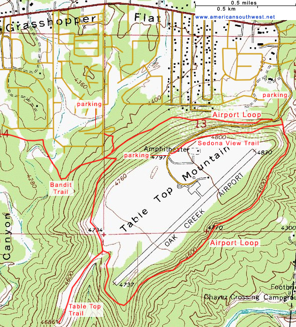
The designated parking for the Airport Loop Trail is about halfway along Airport Road, on the south side, and it has space for a dozen vehicles (no RVs). The road is narrow, with no other verges nearby, and also not particularly suitable for walking along, though there is more parking space a quarter of a mile back, at the edge of a residential area. Two other possible start places are the much bigger parking lot at the entrance to the airport, from where the 0.6 mile Sedona View Trail leads back to the Airport Loop trailhead, or the free parking at Sunset Park, along Sunset Drive below the north face of the mesa - a very short path from here links with the loop.
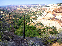
This description is counter-clockwise, starting from Airport Road. The trail heads west through shaded, wooded surroundings, staying close to the road whilst slowly descending. It levels out after a while, reaching the junction with the connecting path from Sunset Road, closely followed by another intersection, with the Bandit Trail to the west. After here the route climbs fairly steeply, through one switchback, then becomes straight, heading southwards up to level, open terrain at the western tip of the mesa, where it meets the Table Top Trail, leading to a viewpoint at the end of a narrow ridge.
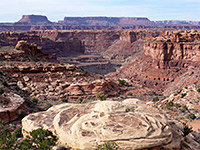
The main path comes briefly close to the airport boundary fence at end of the runway, then bends northeast and drops down below the rim, before leveling out and staying almost flat all the way back to the trailhead. Views along this south side of the mesa are even better than the north as there is less vegetation, and the scenery below is less developed, centered on Oak Creek valley. The path passes several red rock exposures, and there are more red slopes at its north end, around an isolated butte, an extension of the main mesa. On a saddle at its base is a walled viewpoint, with information board about Munds Mountain Wilderness to the east, this overlook opposite the junction with the Sedona View Trail, and just a few yards from the end of the hike at the Airport Drive trailhead.
The path offers spectacular, ever-changing views all the way - there are no closer peaks to block the panoramas apart from a small butte to the north, so many of Sedona's landmarks can be seen, from the Dry Creek area in the northwest, across Capitol Butte, Soldier Pass and Wilson Mountain, east to Munds and Lee mountains, and south to Cathedral Rock. The airport itself is out-of-sight since the path mostly stays below the plateau rim, by between 100 and 200 feet. The trail is surprisingly peaceful and gives a sense of remoteness despite the suburbs being in view, as it is not near any main roads, and the airport receives only a small number of flights. The path can however be quite busy, even though visitor numbers are limited due to the small trailhead parking.
The loop is 3.2 miles in length, with only 150 feet of elevation change; it can be extended to include the 0.5 mile Table Top Trail (#212), a spur which follows an extension of the mesa to the southwest.
Location
Sedona map.
Photographs
37 views along the Airport Loop Trail.
Airport Loop Trailhead
The designated parking for the Airport Loop Trail is about halfway along Airport Road, on the south side, and it has space for a dozen vehicles (no RVs). The road is narrow, with no other verges nearby, and also not particularly suitable for walking along, though there is more parking space a quarter of a mile back, at the edge of a residential area. Two other possible start places are the much bigger parking lot at the entrance to the airport, from where the 0.6 mile Sedona View Trail leads back to the Airport Loop trailhead, or the free parking at Sunset Park, along Sunset Drive below the north face of the mesa - a very short path from here links with the loop.
Northern Trail
This description is counter-clockwise, starting from Airport Road. The trail heads west through shaded, wooded surroundings, staying close to the road whilst slowly descending. It levels out after a while, reaching the junction with the connecting path from Sunset Road, closely followed by another intersection, with the Bandit Trail to the west. After here the route climbs fairly steeply, through one switchback, then becomes straight, heading southwards up to level, open terrain at the western tip of the mesa, where it meets the Table Top Trail, leading to a viewpoint at the end of a narrow ridge.
Southern Trail
The main path comes briefly close to the airport boundary fence at end of the runway, then bends northeast and drops down below the rim, before leveling out and staying almost flat all the way back to the trailhead. Views along this south side of the mesa are even better than the north as there is less vegetation, and the scenery below is less developed, centered on Oak Creek valley. The path passes several red rock exposures, and there are more red slopes at its north end, around an isolated butte, an extension of the main mesa. On a saddle at its base is a walled viewpoint, with information board about Munds Mountain Wilderness to the east, this overlook opposite the junction with the Sedona View Trail, and just a few yards from the end of the hike at the Airport Drive trailhead.
Topographic Map of the Airport Loop Trail

Airport Loop Trail - Similar Hikes
All Contents © Copyright The American Southwest | Comments and Questions | Contribute | Affiliate Marketing Disclosure | Site Map