Texas National Parks, National Monuments and National Recreation Areas
Other Texas listings: state parks and state natural areas.
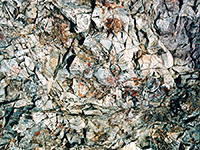
On the windswept plains of the Texas panhandle, Alibates Flint Quarries National Monument contains the remains of several flint quarries that were used by the native inhabitants of this region for up to 12,000 years. In order to protect the quarries, and the remaining flint, the site can only be visited as part of a ranger guided tour, reserved in advance. The monument occupies a small area adjacent to Lake Meredith NRA, 35 miles from Amarillo. Description | Photographs |
|
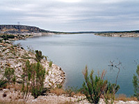
Lake Amistad is a large, branched reservoir along the Rio Grande, formed in 1960 by construction of a dam near Del Rio, the last town of any significance along the river before El Paso, 680 river miles further west. Access to the shoreline is rather restricted and recreation is mostly limited to water-based activities, principally fishing, boating and scuba diving - since the water is unusually clear, and the lake has interesting underwater rock formations including submerged caves. Description |
|
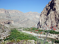
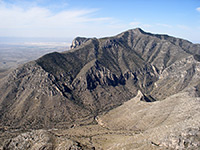
One of the most remote national parks in the US, Big Bend lies over an hour's drive from the nearest town, in a wild and rather inaccessible region adjacent to the Rio Grande and the Mexican border. The park has a fantastic mixture of desert, mountain and canyon scenery, with many hiking trails and endless opportunities for off trail exploration and primitive camping. Animal and plant life are particularly varied and plentiful, including over 60 species of cacti plus other spiky plants. Description | Map | Southeast | Southwest | Chisos Mountains |
|
| Big Thicket National Preserve The Big Thicket once stretched across much of southeast Texas - a dark, dense forest, mixed with swamps, rivers and patches of prairie. Nine remaining sections came under NPS protection in 1974, as the nation's first natural preserve; this is crossed by various roads, 40 miles of trails and several navigable waterways, and is popular for many kinds of recreation. |
|
| Chamizal National Memorial This urban park consists of a visitor center and museum in downtown El Paso, commemorating the Chamizal Convention of 1963, which resolved a long standing border dispute with neighboring Mexico. |
|
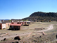
Fort Davis NHS has over 20 buildings from a historic frontier fort in west Texas - in the Davis Mountains, along the old trade route between El Paso and San Antonio. The fort saw service between 1854 and 1891, and became a national historic site in 1961. Besides the walking tour of the buildings, visitiors may hike along several trails in the mountains, for good elevated views of the fort and the nearby town. Description | Photographs |
|
Relatively few people visit Guadalupe Mountains National Park in far west Texas, perhaps due to lack of a central attraction, a scenic drive or named viewpoints. The park contains southern end of the Guadalupe Mountains, an isolated range surrounded in all directions by desert, and is primarily a hiking destination; the mountains are crossed by a good network of trails and the region has varied climate zones with differing wildlife and vegetation, interesting geology, and many photographic opportunities. Description | Map |
|
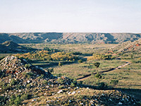
The large reservoir of Lake Meredith along the Canadian River is managed by the NPS as a national recreation area, providing many recreational opportunities as well as supplying drinking water for 11 Texas cities including Lubbock and Amarillo. Like most other Texas lakes, Meredith has a long meandering shoreline and is bordered by low, grassy hills, mostly inaccessible by road. Description | Map |
|
| Lyndon B Johnson National Historical Park The life of the 36th president is celebrated by Lyndon B Johnson National Historical Park near Fredericksburg, containing a variety of sites including the LBJ Ranch, the Johnson family cemetery and the president's boyhood home. |
|
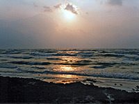
South of a short developed area near Corpus Christi, North Padre Island is completely empty for 80 miles - a thin strip of white sands and grassy dunes, most of which is accessible only to 4WD vehicles, driving along the beach. All is protected as a national seashore, which has a few facilities near the entrance (nature trails, campground, visitor center), where most people congregate. South of here the sands are firm enough for 2WD vehicles for around 5 miles. Primitive camping is allowed anywhere on the beach; only activities in the dunes are restricted, to protect the wildlife. Description | Map | Weather | Photographs | Panorama |
|
| Palo Alto Battlefield National Historical Park In far south Texas near Brownsville, Palo Alto Battlefield NHS protects the site of one of the major conflicts of the US-Mexican war, in May 1846. The park has a visitor center and a short trail to an overlook of the battlefield, but no other facilities. |
|
| Rio Grande National Wild & Scenic River Nearly 200 miles of the Rio Grande in west Texas are protected as a Wild & Scenic River - through Big Bend National Park and some distance further downstream. Road access is limited; the main activity is rafting along the river. |
|
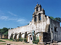
Several dozen Spanish missions were constructed across south Texas in the 18th century, and four of the best preserved, in San Antonio, may be visited as part of a national historical park, which incorporates various sites and tracts of land along the San Antonio River connected by the Mission Trail, a 12 mile route that links The Alamo in the center with Mission Espada, southernmost of the four churches. Description | Photographs | The Missions |
|
| Waco Mammoth National Monument This monument was established July 2015 to protect a wooded site near the Bosque River on the north side of Waco, where the fosslized remains of 24 Columbian mammoths were discovered in 1978. The monument has a visitor center and museum, from where a short walk leads to the fossil location; specimens can still be seen in situ. |
All Contents © Copyright The American Southwest | Comments and Questions | Contribute | Affiliate Marketing Disclosure | Site Map