New Mexico National Parks and National Monuments
Other New Mexico listings: national forests and state parks.
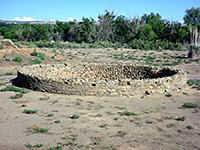
The Aztec Ruins were believed to be of Mexican origin when first discovered, but like all other such sites in northern New Mexico they are a relic of native Southwest tribes, dating from around the 12th century. The well preserved village has almost 400 walled rooms on three levels, plus over a dozen kivas, one of which is fully reconstructed. The national monument is located 13 miles northeast of Farmington, close to US 550. Some of the site is closed to the public and as yet unexcavated. Description | Photographs |
|
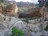
Besides some of the most interesting and unusual ancient ruins in the Southwest, Bandelier National Monument also contains steep narrow canyons with plentiful wildlife, mountains rising to 10,000 feet, and a scenic section of the Rio Grande. The best ruins are found in cavities in the volcanic rocks (tuff) lining the walls of Frijoles Canyon, and may be visited by a 2 mile loop trail. The other main path descends this canyon to the Rio Grande, passing two high waterfalls. The national monument is located in the hills south of Los Alamos, surrounded by the Santa Fe National Forest. Description | Hiking | Map | Frijoles Canyon Trail | Falls Trail | Tyuonyi Overlook Trail |
|
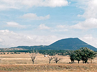
In the northeast corner of New Mexico, surrounded by flat prairie and low mountain ranges, Capulin is a 1,000 foot high dormant volcano, part of a long band of vulcanism stretching from southeast Colorado into Arizona. There are two short paths in the small national monument containing the volcano; one across some patches of overgrown lava near the visitor center, the other a loop around the crater rim. Description | Photographs |
|
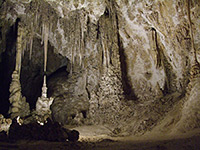
At the edge of the Guadalupe Mountains in far south New Mexico, Carlsbad is one of the oldest known and most famous cave systems in the world. Discoveries of new caverns in the vicinity are still being made, and much is not open to the public but the main section has several vast interlinked underground chambers up to 250 feet tall, filled with amazingly colorful and varied formations. Either ranger-led or self-guided tours are available, once visitors have descended the 900 feet to the caverns by means of an elevator. Description | Map | Other Activities | Photographs |
|
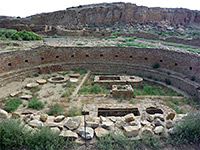
The remote Chaco site of northwest New Mexico has the largest, best preserved and architecturally advanced of all ancient Southwestern villages, made even more evocative by the great desolation and emptiness of the surrounding countryside. The park is reached by a 21 mile drive on bumpy gravel tracks across the flat, sandy plains of the Navajo Indian Reservation; once there, a paved, 8 mile loop road passes most of the major ruins, of which the best are Hungo Pavi, Chetro Ketl and Pueblo Bonito. Description | Hiking | Map | Photographs | Scenic Drive |
|
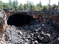
The most extensive lava fields in New Mexico are found south of Grants in the northwest of the state, and cover an area of 60 by 35 miles. The best views are from NM 117 which follows the edge of the lava flow passing a few named overlooks and trailheads, plus La Ventana Natural Arch, the largest such feature in New Mexico. The monument is quiet and relatively undeveloped; there is no campground, no paved footpaths and only limited access to the lava fields. Description | Map | Big Tubes | El Calderon |
|
El Morro is one of New Mexico's smaller national monuments, containing a sandstone promontory at the foot of which is a spring that provides a reliable, year round water source and so has been a regular stopping point for travelers over the centuries. The rock is covered with many historical inscriptions from the pueblo, Spanish and American periods, and may be reached by highway 53 from Grants (40 miles). Above the rock is a short trail to some ancient ruins. Description and Map | Photographs |
|
| Fort Union National Monument (NPS) Ruins of a fort built in 1851, and many ruts from the wheels of 19th century wagons along the Santa Fe Trail are the two features of Fort Union National Monument, 7 miles north of Watrous on I-25 in northeast New Mexico. |
|
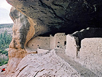
Gila Cliff Dwellings is one of the more remote NPS sites in the Southwest, completely surrounded by wilderness areas in the mountains of the Gila National Forest and reached only by a steep and winding road that crosses uninhabited land for 40 miles. Once here, visitors can see the ruins of interlinked cave dwellings built in five cliff alcoves by the Mogollon peoples between 1275 and 1300 AD, reached today by an easy one mile loop trail along a narrow canyon. Description | Photographs |
|
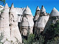
Once a little-visited BLM site, the tent rocks became a national monument in 2001 and now receive quite a few visitors, due in part to the easy access, just off I-25 between Albuquerque and Santa Fe. The rocks cover a small area but are very photogenic, and unique in the Southwest - hundreds of white, pinkish or grey spires, sharply conical in shape, lacking any covering vegetation, that occur in several groups on the east side of a narrow canyon in the hills on the west side of the Rio Grande. Description | Photographs | Hiking |
|
| Northern Rio Grande National Heritage Area (NPS) Rather than a single entity, this historical park includes many different sites spread along the Rio Grande from Albuquerque north to the Colorado River - components include pueblos, historic buildings, scenic drives and the river itself. |
|
The newest national monument in New Mexico was established May 21st 2014, and it comprises four separate areas around the city of Las Cruces, containing five isolated mountain ranges, each forming 'sky islands' above the surrounding plains of the Chihuahuan Desert. These are the Sierra de las Uvas and the Robledo Mountains to the northwest, the Potrillo Mountains in the southwest, the Doña Ana Mountains in the north (the smallest area) and the Organ Mountains to the east. The most developed section is Aguirre Spring Recreation Area, within the Organ Mountains. |
|
| Pecos National Historical Park (NPS) Several ancient sites at the edge of the mountains 25 miles east of Santa Fe are protected as Pecos National Historical Park, including a ruined pueblo, several Spanish missions, sections of the Santa Fe Trail, a ranch and a Civil War battlefield. |
|
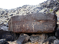
Archaeological sites, ancient volcanoes and around 24,000 rock engravings are the highlights of Petroglyph National Monument, occupying several locations on the volcanic mesa northwest of Albuquerque. The main site is Rinconada Canyon, where a 2.2 mile loop trail passes several hundred petroglyphs; other significant locations are a few miles north at Boca Negra Canyon and Piedras Marcadas Canyon. Description | Photographs |
|
| Prehistoric Trackways National Monument (BLM) This little-known national monument was established in 2009 to protect an area of fossilized footprints of dinosaurs and other creatures from the Palaeozioc era, in the Robledo Mountains a few miles northwest of Las Cruces. |
|
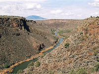
Created 25th March 2013, this new national monument encompasses a large area of high desert lands in the north of the state, adjoining the Colorado stateline. The two main landscape features are the Taos Plateau Volcanic Field, an extensive plain dotted with ancient volcanoes and lava flows, and the Rio Grande, which flows through a series of deep canyons. The most spectacular section of the river is contained within Wild Rivers Recreation Area, a separate preserve within the national monument. |
|
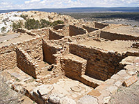
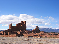
The little visited Salinas Missions National Monument preserves the ruins of three 17th century Spanish missions in the grasslands of central New Mexico, near the small town of Mountainair. Gran Quivira is the most remote but also the well known, containing the remains of two churches and a sizeable, partly reconstructed Indian pueblo. The other two sites (Abó and Quarai) are both centered on a large church built of red sandstone, plus other buildings and unexcavated pueblo ruins. Description and Map | Photographs |
|
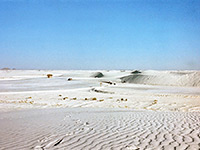
Perhaps the most scenic and unusual NPS unit in New Mexico, White Sands contains 275 square miles of pure white gypsum dunes, deposited by the prevailing winds after being eroded from the nearby San Andres Mountains. The dunes are 24 miles southeast of Alamogordo along US 70, and also extend across most of the adjacent White Sands Missile Range, activities which in the past sometimes caused the park to be closed for a few hours. Description | Photographs |
All Contents © Copyright The American Southwest | Comments and Questions | Contribute | Affiliate Marketing Disclosure | Site Map