Highlights:
Spectacular dunes of pure white gypsum, covering 275 square miles; one of the most magical places in the Southwest, especially at sunset or sunrise. The park has a few trails and viewing areas, while off-trail exploration is allowed in most areas
Nearby town:
Alamogordo, 13 miles
Management:
Location:
Seasons:
All year
Rating (1-5):
★★★★★
Weather:


White Sands NP is part of the New Mexico Highlights itinerary
Featured Hotel
Holiday Inn Express Alamogordo
 A south Alamogordo hotel with fitness center and outdoor pool, along White Sands Blvd near the US 54 intersection, 14 miles from the national monument visitor center
Check Rates
West of Alamogordo, a vast area of desert and mountain ranges 100 by 40 miles in extent is closed to public access and used by the military for various kinds of weapons testing; this includes the Trinity Site where the first atomic bomb was detonated, in July 1945. Determined tourists may visit on two days each year, the first Saturdays of April and October, when accompanied tours are provided.
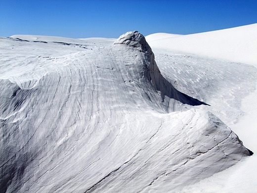
The only other feature of interest in this otherwise desolate and unwelcoming land is 60 miles south in the flat Tularosa Basin, where for thousands of years the prevailing westerly winds have deposited gypsum powder - formerly eroded from the nearby San Andres Mountains, washed down by rainwater and deposited in the seasonal Lake Lucero, a few miles southwest - creating a huge area of white dunes covering 275 square miles.
About half of the sands are within the boundaries of White Sands National Park, one of the most unusual and magical places in the Southwest. The preserve was established in 1933 as a national monument, and upgraded to a national park in December 2019, accompanied by land transfers to and from the adjacent missile range, resulting in a net increase of 4,855 acres.
White Sands Table of Contents
- Map of the national park
- Photographs
- Military bases
- Approach to White Sands
- Trails
- Camping
- Wildlife
- Sunset
- Featured hike; Alkali Flat Trail
- Nearby places
- Similar places
Location
Map of White Sands National Park.
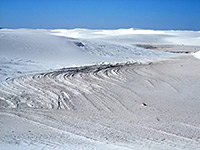
Photographs
General views, Alkali Flat Trail.
Military Bases
The national park is entirely surrounded by the White Sands Missile Range; just east is the Holloman Air Force Base, and a few miles north is one of the space shuttle landing sites. The space theme is reflected in the nearby town of Alamogordo, home to the International Space Hall of Fame and the Space Theater. The dunes extend north into the missile range for another 12 miles.
Approach to White Sands
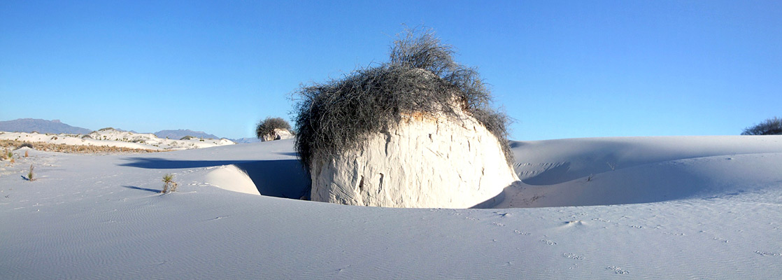
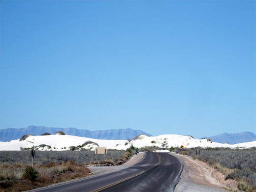
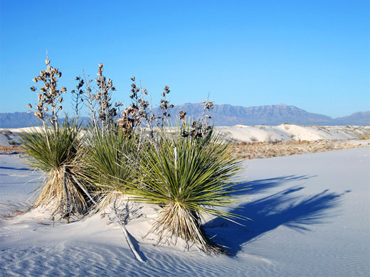
The main road past White Sands National Park is US 70; this (and the dunes) is closed to all traffic for a few hours once or twice a week as test missiles are fired overhead. A paved road (the Dunes Drive) leads from the visitor center at the park entrance on US 70 to the start of the sands 2 miles north. The edge dunes are just a few feet high and support some plant life, with several species of grass, yucca and saltbush managing to survive at scattered points, but further into the park there is little or no vegetation, just an unbroken white landscape. The road is paved for a while although blowing sand often covers the surface; towards the center though, the surface is just compacted gypsum, and the 'road' becomes a series of large cleared areas, which can be adapted to changes in dune position, as the sands move by up to 20 feet per year. In this surreal environment, everything is white, dazzlingly bright and intensely hot in summer, capped on most days by a clear blue sky.
Trails of White Sands
White Sands National Park has three short nature trails and one longer hiking path, although cross-country walking is allowed anywhere within the sands, up to 106° 20' longitude, west of which permits are required. The 0.15 mile Playa Trail leads to a small dry lake bed that occasionally fills with shallow water after recent rains. On the opposite side of the road, the Dune Life Trail loops for one mile around an area just inside the southeast edge of the dunes, and has notices about how plants and animals have adapted to life in this sandy environment. Further along the road, the Interdune Boardwalk is a 0.2 mile raised walkway across flat land between two lines of dunes, ending at a nice viewpoint. The Alkali Flat Trail is rather more challenging - a 4.6 mile loop, much of which is across soft, shifting sands, to the start of a vast flat area beyond the northwest edge of the dunes. Despite these varied paths, however, and the striking scenery, many people visit the park just for recreation - picnicking, sunbathing and sand sledding are the main activities.
Camping
There are no camping facilities in the national park apart from ten primitive sites in the dunes, well away from the main road. The closest accommodation is in Alamogordo, 15 miles northeast, while the nearest free camping is in the Lincoln National Forest, 5 miles further east along US 82. A good public campground is available 26 miles away at Oliver Lee State Park in the foothills of the Santiago Mountains, reached by US 54 south of Alamogordo.
Wildlife of White Sands National Park
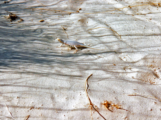
The gypsum dunes support a limited range of wildlife, some of which has evolved white coloration to match the surroundings, and exist as species unique to this region, such as the white sands wood rat, the Apache pocket mouse, the white sands prairie lizard and the bleached earless lizard. The most prominent plant in the dunes is the soaptree yucca, a species with numerous thin narrow leaves and an extensive root system that can stabilize a mound of sand and remain in place after wind causes the surrounding dune to more away.
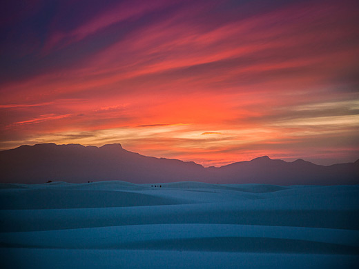
Sunset
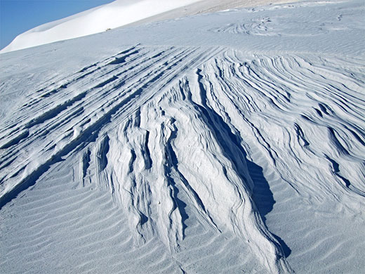
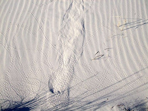
Walking through the dunes is an unforgettable experience; often there are no other footprints ahead, just wind-created ripples and occasional lizard tracks. When daylight begins to fade after a sunny day, the sands take on a reddish-pink hue, and the surface patterns become more pronounced as the shadows lengthen. An overwhelming sense of peace and stillness descends, and when the sun finally dips below the distant San Andres Mountains, for a few minutes the land is bathed in a mysterious light, as the sands themselves seem to glow while the horizon on all sides becomes dark. If experience is a guide, though, this magical moment is difficult to photograph effectively.
Hiking at White Sands
Alkali Flat Trail
★★★★★
★★★★★
4.6 miles, level overall
Loop path across large dunes, completely lacking any vegetation, to a dry lake bed (Alkali Flat) at the edge of the sandsWhite Sands - Nearby Places
- Aguirre Spring Recreation Area (36 miles) - wooded slopes rising to jagged granite peaks, overlooking White Sands
- Oliver Lee Memorial State Park (26 miles) - historic ranch, a cactus garden, a popular campground and a trail into the Sacramento Mountains
White Sands - Similar Places
- Great Sand Dunes National Park, Colorado - another large dune area, here more traditionally colored
- Great Salt Lake Desert, Utah - huge expanse of white salt flats
All Contents © Copyright The American Southwest | Comments and Questions | Contribute | Affiliate Marketing Disclosure | Site Map