Highlights:
Ancient dwellings carved into light-colored volcanic cliffs, at the edge of a narrow, wooded canyon - a tributary of the Rio Grande. The extensive backcountry includes other ruins and a great variety of landscapes, spanning over 5,000 feet of elevation. A good network of trails
Nearby town:
Los Alamos, 12 miles
Management:
Location:
Seasons:
All year; especially popular during summer. Winters are cold and snowy
Rating (1-5):
★★★★★
Weather:

Bandelier NM is part of the New Mexico Highlights itinerary
Featured Hotel
Holiday Inn Express Hotel Los Alamos
 Scenically-situated hotel on a wooded plateau along the eastern approach to Los Alamos (Hwy 502), 15 miles from Bandelier. Free full breakfast provided
Check Rates
Bandelier National Monument is an unexpected delight, containing some of the most unusual and interesting ancient ruins in the Southwest, petroglyphs and pictographs, steep narrow canyons with plentiful wildlife, mountains rising to 10,200 feet, many acres of unspoilt backcountry and a colorful section of the Rio Grande valley. The monument is just a few minutes drive from the scientific research town of Los Alamos, and close to other popular destinations including Santa Fe, the Jemez Mountains and several historic pueblo settlements.
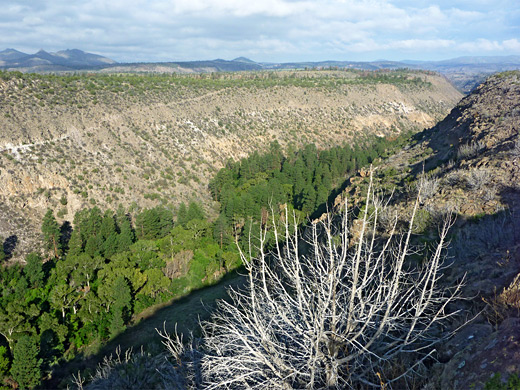
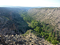
Visitor activities are concentrated in a short section of Frijoles Canyon, a 400 foot deep, sheer-walled gorge, as here are found the main ruins, but a network of lightly-used paths heads south and west to other ancient sites, while some higher elevation areas are accessible from Hwy 4 to the north. In recent years the canyon has been affected by several huge flash floods, one of which permanently closed a popular trail that used to lead all the way to the Rio Grande.
Visitor activities are concentrated in a short section of Frijoles Canyon, a 400 foot deep, sheer-walled gorge, as here are found the main ruins, but a network of lightly-used paths heads south and west to other ancient sites, while some higher elevation areas are accessible from Hwy 4 to the north. In recent years the canyon has been affected by several huge flash floods, one of which permanently closed a popular trail that used to lead all the way to the Rio Grande.
Bandelier Table of Contents
- Map of the national monument
- Photographs
- Access, from Hwy 4
- Volcanic rocks
- Frijoles Canyon
- Other ancient sites
- Hiking at Bandelier
- Wildflowers
- Nearby places
- Similar places
Location
Map of Bandelier National Monument, showing roads and trails.
Photographs
Frijoles Canyon/Alcove House, Yapaashi. All Bandelier photographs.
Bandelier Access
The approach to Bandelier is along Hwy 4 - either from the west, across the pretty, wooded country of Valles Caldera and the Santa Fe National Forest, or north and east from the Rio Grande valley via Los Alamos, a road which passes a number of secretive laboratories, well hidden in the thick forest and protected by high fences. A short side-road forks south at the entrance to the national monument, passing along the top of a ridge that gives good views over the valley beneath, then descending steeply into Frijoles Canyon, ending at a visitor center with somewhat limited parking facilities. Space is at a premium in this narrow valley, and in summer the parking area is only open to private vehicles if arriving before 9 am; later arrivals have to use a free shuttle system, starting from a larger parking lot on the canyon rim. The 66-site Juniper Campground, for tents and RVs, is also located on the plateau, where there is much more room.
Volcanic Rocks
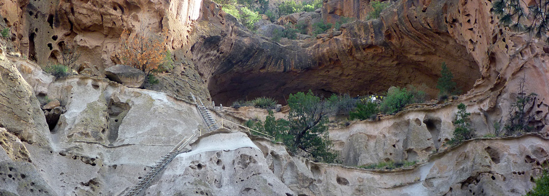
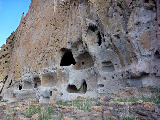
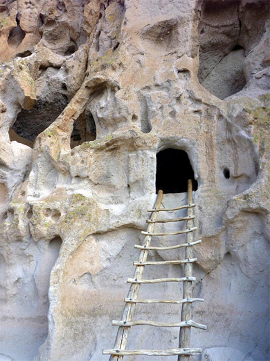
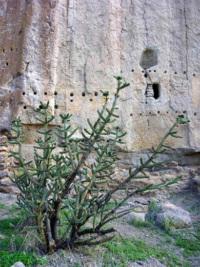
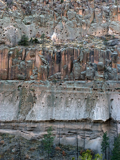
Frijoles Canyon has been created by Frijoles Creek, eroding through thick deposits of volcanic rock - mainly tuff, which is full of natural cavities - originally air pockets in ash deposits from volcanic eruptions several thousand years ago. These may be ten or twenty feet in diameter, and were used by the Anasazi peoples between 700 and 450 years ago as the basis of their villages. Selected cavities were enlarged, linked together and augmented to form numerous clusters of dwellings extending over several miles of this rocky land southeast of the Jemez Mountains. The ash originated from volcanoes at the site of Valle Grande Peak, a few miles west. Hot springs in the nearby forests still hint of continuing subterranean thermal activity. Together with some more conventional ruins along the canyon floor, many of these unusual dwellings are just a short walk away from the national monument visitor center, and a 2 mile loop path (with an upstream extension to the Ceremonial Cave, or Alcove House) allows for easy viewing.
Frijoles Canyon
The entrance road follows a narrow promontory bordered by Chaquehui Canyon on the east side, then drops down into the larger Frijoles Canyon to the west, ending at a shady parking lot lined by tall trees and quite a few buildings, including Frijoles Canyon Lodge, a historic, Spanish pueblo-style residence constructed in the 1930s. The whole complex contains over 30 structures, all protected as Bandelier CCC Historic District. Today, facilities include a visitor center, museum, bookstore, gift shop and snack bar. Paths lead upstream to the main ruins, downstream to Upper Frijoles Falls and west into the extensive backcountry.
Other Ancient Sites
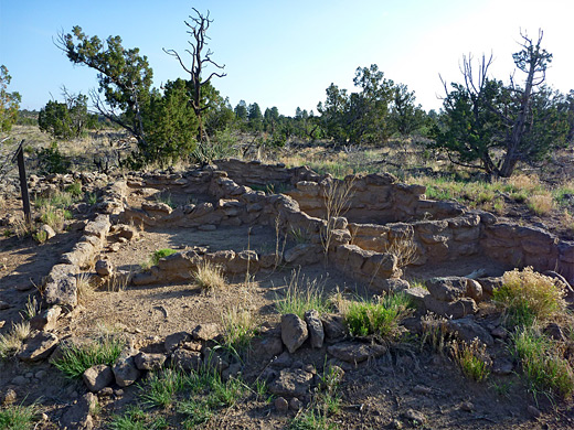
More ruins, all of them unexcavated, are scattered along adjacent canyons within the monument boundary, but apart from one (Frijolito) that may be visited by a relatively easy 2.5 mile loop hike, all are far away. The two largest sites are Yapashi, a not-so interesting ruin on top of a mesa between Alamo and Capulin canyons (6 miles from the visitor center), and Painted Cave, a spectacular pictograph panel in a large alcove towards the lower end of Capulin Canyon. This latter is reached by a strenuus hike of 11 miles, and is not recommended for day trips. A separate section of the national monument is found 12 miles northwest along Hwy 4, near the junction with NM 502. This is Tsankawi - a large dwelling site on a plateau with good views over the Rio Grande, toured by a 1.5 mile loop trail that also encounters many petroglyphs and small cave dwellings. Besides Bandelier, there are many other ancient settlements in New Mexico, second in number only to those in neighboring Arizona; they include Chaco Culture - a remote location with many large well-preserved structures, Aztec Ruins near Farmington, and the Gila Cliff Dwellings, further south in the Mogollon Mountains.
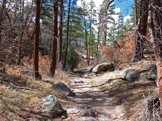
Trails of Bandelier
All hikes in Bandelier National Monument.
Featured Bandelier Trails
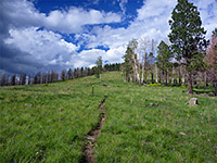
Cerro Grande Trail
★★★★★
★★★★★
2 miles, 1250 feet
Climb through open woodland and floral meadows to a rounded volcanic summit, the highest point in the national monument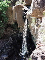
Falls Trail
★★★★★
★★★★★
1.5 miles, 400 feet
Path downstream along Frijoles Canyon, from wooded surroundings around the visitor center into more desert-like terrain, ending at the brink of the Upper Falls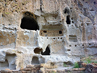
Frijoles Canyon Trail (Main Loop)
★★★★★
★★★★★
1.2 miles, 200 feet
Easy walk to the major ruins, including the Ceremonial Cave (Alcove House)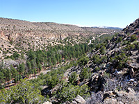
Frijolito Loop Trail
★★★★★
★★★★★
2.5 miles, 520 feet (loop)
Loop to an unexcavated ruin on the mesatop south of Frijoles Canyon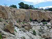
Tyuonyi Overlook Trail
★★★★★
★★★★★
1.1 miles, 140 feet
Route across a plateau on the north rim, to a viewpoint of the Frijoles Canyon ruins
Yapashi Pueblo Trail
★★★★★
★★★★★
6 miles, 800 feet
Long, little-used path across mesas and canyons to an unexcavated backcountry puebloBandelier Wildflowers

Photographs and descriptions of flowering plants found in the national monument
Bandelier - Nearby Places
- Jemez Mountains (adjacent) - forested mountains with hot springs and rock formations
- Kasha-Katuwe Tent Rocks National Monument (5 miles direct but 90 miles by road) - unusual volcanic rocks
Bandelier - Similar Places
- Gila Cliff Dwellings National Monument, New Mexico - ancient cave ruins in a distant canyon
- Montezuma Castle National Monument, Arizona - a single large dwelling in a cliff alcove
- Walnut Canyon National Monument, Arizona - cliff dwellings in a steep canyon
All Contents © Copyright The American Southwest | Comments and Questions | Contribute | Affiliate Marketing Disclosure | Site Map