Highlights:
Also known as Red Cliffs Desert Reserve; a 25 mile-wide band of red rocks of Navajo Sandstone and the Kayenta Formation, on the north side of St George, containing canyons, arches, fossils, eroded formations, volcanic features and riparian areas, home to diverse wildlife and crossed by over 130 miles of trails
Nearby town:
Management:
Location:
37.224, -113.406 (Red Cliffs Recreation Area)
Seasons:
All year
Rating (1-5):
★★★★★
Weather:


Featured Hotel
Best Western Coral Hills
 Popular hotel with an elevated position on the north side of St George, 6 miles from Snow Canyon. Free hot breakfast and an outdoor pool
Check Rates
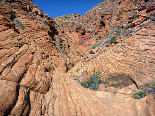
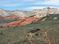
Red Cliffs Desert Reserve is a sizable, BLM-administered area of predominantly red rocks - Navajo Sandstone and the Kayenta Formation, north of St George, containing many canyons, arches, eroded formations, volcanic sites, petroglyph panels and other interesting features, and it forms by far the largest component of Red Cliffs National Conservation Area, which also contains Snow Canyon State Park and several smaller sites.
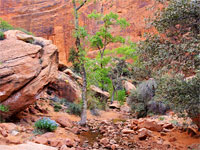
Within the preserve are over 130 miles of tracks and trails, while many of the drainages are also suitable for hiking, yet the place as a whole remains relatively little-known and little visited. Weeks could be spent exploring the area, and doubtless there are photogenic formations and rock art sites still to be discovered.
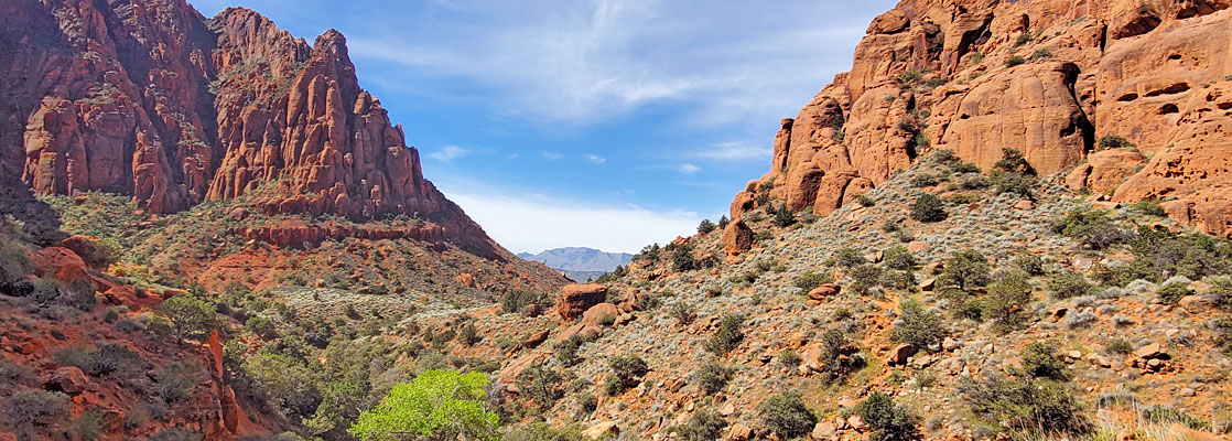
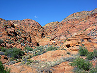
The one developed site is towards the east edge - Red Cliffs Recreation Area, which is centered on the lower end of the scenic canyon of Quail Creek, a year-round watercourse through a pretty, slot-like ravine; just downstream, on the south side of I-15, it flows into Quail Creek Reservoir.
Away from here are many lightly-used trailheads, all along the accessible south edge of the NCA, and more on Hwy 18 which heads north from St George, past the state park. The northern edge of the NCA may be reached from Cottonwood Road/Danish Ranch Road (0431), an unpaved though relatively good track through high country on the south side of the Pine Valley Mountains, within Dixie National Forest.
Within the preserve are over 130 miles of tracks and trails, while many of the drainages are also suitable for hiking, yet the place as a whole remains relatively little-known and little visited. Weeks could be spent exploring the area, and doubtless there are photogenic formations and rock art sites still to be discovered.
The one developed site is towards the east edge - Red Cliffs Recreation Area, which is centered on the lower end of the scenic canyon of Quail Creek, a year-round watercourse through a pretty, slot-like ravine; just downstream, on the south side of I-15, it flows into Quail Creek Reservoir.
Away from here are many lightly-used trailheads, all along the accessible south edge of the NCA, and more on Hwy 18 which heads north from St George, past the state park. The northern edge of the NCA may be reached from Cottonwood Road/Danish Ranch Road (0431), an unpaved though relatively good track through high country on the south side of the Pine Valley Mountains, within Dixie National Forest.
Red Cliffs Table of Contents
Location
Map of Red Cliffs National Conservation Area.
Red Cliffs - Sites in the East
Right at the east edge of the NCA is the Hurricane Cinder Knolls, a volcanic area on the south side of the Virgin River, centered on a pair of cinder cones, each reached by a trail. Nearly opposite is Sandstone Mountain, a detached exposure of the Navajo sandstone concealing several arches, again crossed by a few trails. These two sites are south of I-15 while all the other sections of the NCA are to the north, starting, to the east, at Red Cliffs Recreation Area around Quail Creek. The biggest roadless section of the reserve the adjoins this to the west, and this contains several more creeks and many more trails. The northern part of this is the Cottonwood Canyon Wilderness, across the Pine Valley Mountain foothills.
Red Cliffs - Sites in the West
Beyond this central region, to the west, is the southern end of Cottonwood Road, which from St George is initially paved, then unpaved, gradually becoming rougher, accessing several more trailheads including the Winchester Trail to Buckskin Hollow. A couple of miles west of this, Hwy 18 crosses a small part of the NCA and runs alongside Snow Canyon State Park, which is bordered by the westernmost NCA section, Red Mountain, another large exposure of red sandstone with just two trails along the western edge; Hellhole and Red Mountain, plus a few more shorter routes to the northeast, starting along Hwy 18.
Red Cliffs - Locations and Trails
Buckskin Hollow
★★★★★
Short drainage through eroded, stripy, thin-layered sedimentary rocks in rich shades of red, yellow and pink. Reached by the Winchester Trail
★★★★★
Short drainage through eroded, stripy, thin-layered sedimentary rocks in rich shades of red, yellow and pink. Reached by the Winchester Trail
Hellhole Canyon Trail
★★★★★
★★★★★
2 miles, 300 feet
Cliff-lined drainage in the Red Mountains, reached by a trail that climbs gradually over a sandy plain then drops down to the streambed at the point where it becomes narrow and enclosed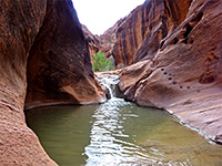
Red Cliffs Recreation Area
★★★★★
A developed site in the NCA; red rock cliffs and ravines, centered on the narrow canyon of Quail Creek
★★★★★
A developed site in the NCA; red rock cliffs and ravines, centered on the narrow canyon of Quail Creek
Snow Canyon State Park
★★★★★
White cliffs, red sandstone outcrops and black lava deposits, with Mojave Desert vegetation and wildlife
★★★★★
White cliffs, red sandstone outcrops and black lava deposits, with Mojave Desert vegetation and wildlife
Red Cliffs - Nearby Places
- Santa Clara River Reserve - three mile section of the Santa Clara River, with many petroglyphs
- Yant Flat Cliffs - swirling, patterned sandstone in a variety of colors, along the north edge of the NCA
Red Cliffs - Similar Places
- Kanab, Utah - small town surrounded by scenic red cliffs and ravines
- Red Rock Canyon National Conservation Area, Nevada - varied Mojave Desert landscapes along the east face of the Spring Mountains near Las Vegas
All Contents © Copyright The American Southwest | Comments and Questions | Contribute | Affiliate Marketing Disclosure | Site Map