Hellhole Canyon
Short, cliff-lined drainage along the south edge of the Red Mountains, reached by a trail that climbs gradually over a sandy plain then drops down to the streambed at the point where it becomes narrow and enclosed. The canyon can be followed upstream a way, past pools and boulders
Length: 2 miles
Elevation change: 300 feet
Difficulty: Easy to the creekbed; moderate upstream
Type: One way
Usage: Low
Season: All year
Trailhead: Verge along N Taviawk Drive
Rating (1-5): ★★★★★
Elevation change: 300 feet
Difficulty: Easy to the creekbed; moderate upstream
Type: One way
Usage: Low
Season: All year
Trailhead: Verge along N Taviawk Drive
Rating (1-5): ★★★★★

The Hellhole Canyon Trail is the westernmost of dozens of paths in Red Cliffs National Conservation Area, otherwise known as Red Cliffs Desert Reserve, which occupies a large area of land north of St George in southwest Utah. The hike is one of the more popular in the reserve since it is relatively short (2 miles), accessed from a paved road, and encounters photogenic scenery with relatively little effort.
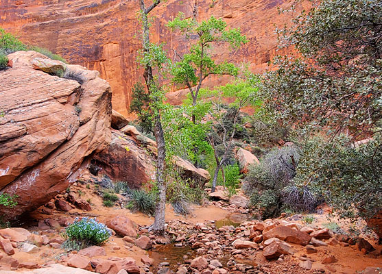
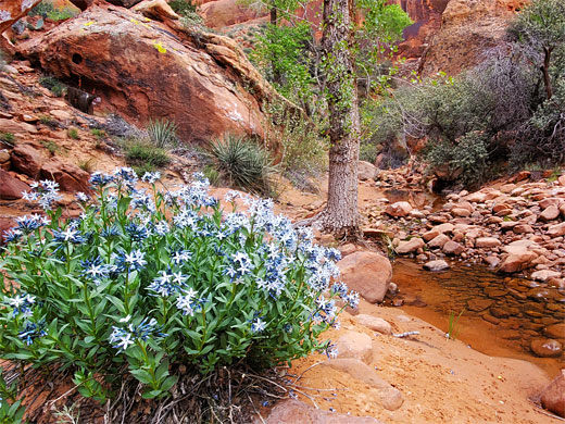
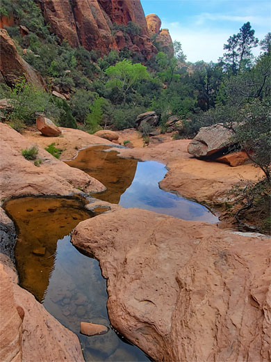
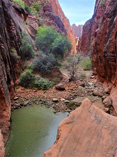
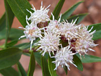
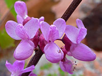
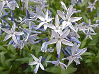
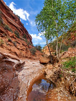
The trail crosses an open area alongside a wash and descends to the streambed as the drainage enters a narrow, sheer-walled canyon with pools, boulders and a good selection of wildflowers. The ravine can only be followed for a few hundred feet before becoming steep and overgrown, but the red rock passageways to this point are very pretty.
The canyon cuts into the southern edge of the Red Mountains, a huge block of deep red Navajo sandstone, and it contains a shallow stream at most times of the year. The ravine is so-named for being dark and somewhat foreboding, due to the tall enclosing cliffs, and yet the lower end least holds no significant dangers.
This stream from Hellhole Canyon is named Kayenta Wash (originally Dry Wash, before the nearby community of Kayenta was established), a tributary of the Santa Clara River, and the hike is sometimes known as the Kayenta Canyon Trail. This location should not be confused with the Hellhole trailhead, 12 miles east in Washington.
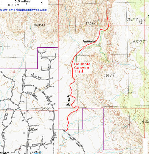
Map of Red Cliffs National Conservation Area.
18 views of Hellhole Canyon.
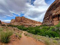
Parking for Hellhole Canyon is on a verge along Taviawk Drive, one of a network of wide, recently-created residential streets on the north side of Ivins, along which are elegant houses, well separated from each other, all with spectacular views of the nearby red cliffs. The parking place is marked with a 'Kayenta Canyon' notice.
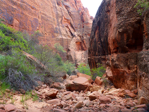
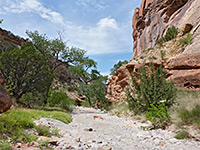
A path leads down from the road to the sandy, usually dry streambed of Kayenta Wash, enclosed by low earthen banks. The usual hiking route is directly upstream, following the wash around several bends, though a faint path does parallel the drainage, crossing the flat land above to the west. Some people take the wash in one direction and the path in the other. The streambed gradually gets more overgrown and rocky; the easiest route is to leave in the vicinity of the first significant tributary, on the west side, and follow the path, over a bench and across a slightly larger tributary, now getting close to the red cliffs.
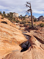
The last section of the path traverses slightly more undulating land, in the wide mouth of Hellhole Canyon, before dropping down to a streambed, just above a major fork in the drainage. This, the west fork, can be followed but it soon gains height very steeply; it is the east fork that allows easier exploration, and this is reached by the last part of the path, climbing the ridge between the two branches, and descending once more to the creekbed.
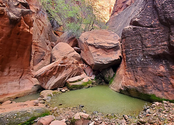
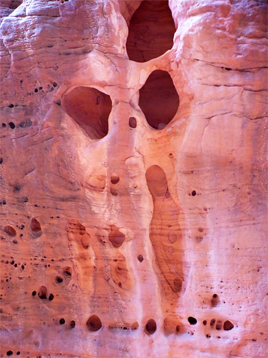
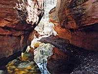
The canyon is shady most of the day due to the tall cliffs, always cool and moist, so is a good destination on a hot summer day. It usually has pools and shallow flowing water. A climb through some boulders leads to a longish flat section, quite open, with a nice vertical wall to the left with much tafoni. This corridor ends at a large pool below a big boulder, which can be climbed, though beyond are many more boulders, as the ravine becomes steeper, so this marks a logical endpoint to the hike.
The trail crosses an open area alongside a wash and descends to the streambed as the drainage enters a narrow, sheer-walled canyon with pools, boulders and a good selection of wildflowers. The ravine can only be followed for a few hundred feet before becoming steep and overgrown, but the red rock passageways to this point are very pretty.
The canyon cuts into the southern edge of the Red Mountains, a huge block of deep red Navajo sandstone, and it contains a shallow stream at most times of the year. The ravine is so-named for being dark and somewhat foreboding, due to the tall enclosing cliffs, and yet the lower end least holds no significant dangers.

This stream from Hellhole Canyon is named Kayenta Wash (originally Dry Wash, before the nearby community of Kayenta was established), a tributary of the Santa Clara River, and the hike is sometimes known as the Kayenta Canyon Trail. This location should not be confused with the Hellhole trailhead, 12 miles east in Washington.
Location
Map of Red Cliffs National Conservation Area.
Photographs
18 views of Hellhole Canyon.
Hellhole Canyon Video
Trailhead
Parking for Hellhole Canyon is on a verge along Taviawk Drive, one of a network of wide, recently-created residential streets on the north side of Ivins, along which are elegant houses, well separated from each other, all with spectacular views of the nearby red cliffs. The parking place is marked with a 'Kayenta Canyon' notice.
The Lower Wash
A path leads down from the road to the sandy, usually dry streambed of Kayenta Wash, enclosed by low earthen banks. The usual hiking route is directly upstream, following the wash around several bends, though a faint path does parallel the drainage, crossing the flat land above to the west. Some people take the wash in one direction and the path in the other. The streambed gradually gets more overgrown and rocky; the easiest route is to leave in the vicinity of the first significant tributary, on the west side, and follow the path, over a bench and across a slightly larger tributary, now getting close to the red cliffs.
Fork in the Canyon
The last section of the path traverses slightly more undulating land, in the wide mouth of Hellhole Canyon, before dropping down to a streambed, just above a major fork in the drainage. This, the west fork, can be followed but it soon gains height very steeply; it is the east fork that allows easier exploration, and this is reached by the last part of the path, climbing the ridge between the two branches, and descending once more to the creekbed.
The Narrows
The canyon is shady most of the day due to the tall cliffs, always cool and moist, so is a good destination on a hot summer day. It usually has pools and shallow flowing water. A climb through some boulders leads to a longish flat section, quite open, with a nice vertical wall to the left with much tafoni. This corridor ends at a large pool below a big boulder, which can be climbed, though beyond are many more boulders, as the ravine becomes steeper, so this marks a logical endpoint to the hike.
Hellhole Canyon Topo Map
Hellhole Canyon - Similar Hikes
All Contents © Copyright The American Southwest | Comments and Questions | Contribute | Affiliate Marketing Disclosure | Site Map