Tom's Canyon Trail
Short route into a narrowing canyon beneath the Vermilion Cliffs, ending at a secluded alcove with dripping waterfall. The path starts by winding through little hills past a residential estate, then enters undeveloped land and follows a seasonal drainage to the base of a pour-off
Length: 1.6 miles
Elevation change: 200 feet
Difficulty: Easy
Type: One way
Usage: Medium
Season: All year
Trailhead: South side of Ladera Lane, about a quarter of a mile from the nearest parking place
Rating (1-5): ★★★★★
Elevation change: 200 feet
Difficulty: Easy
Type: One way
Usage: Medium
Season: All year
Trailhead: South side of Ladera Lane, about a quarter of a mile from the nearest parking place
Rating (1-5): ★★★★★

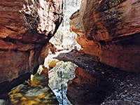
Open to walkers and horseriders, not cyclists, Tom's Canyon Trail (named after a local hiking enthusiast) is a short (1.6 mile), mostly level route on the northeast side of Kanab, following a wide valley leading to a more confined drainage at the foot of the Vermilion Cliffs, ending at an enclosed chamber with dripping waterfall, known as Weeping Rock.
The scenery is pleasant without being spectacular, and the hike is moderately popular, suitable for all times of the year, though it is suggested not to travel immediately after rains or during melting snow, since some parts pass over clay soils which become very slippery. The last third of a mile follows a seasonal stream, flowing through pools and trickling cascades, beneath large cottonwood trees; a good place to cool off during the hot summer months.
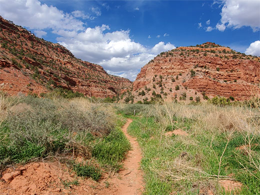
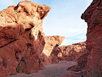
The first part of Tom's Canyon Trail skirts the edge of a recent housing development, crossing undulating ground below a sandstone ridge, a promontory off the Vermilion Cliffs; it then crosses a sagebrush flat and enters the narrower, upper section of the valley. The is no visitor parking at the trailhead, which is within the new estate; the nearest place for this is about a quarter of a mile back on other residential streets, including 300N.
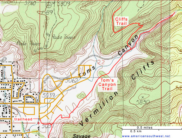
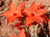
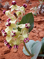
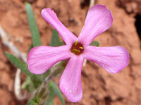
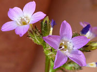
The Tom's Canyon hike starts beside a house on Ladera Lane, where the trailhead notice is accompanied by warnings about no visitor parking; non-resident vehicles left here will be towed away. The path very soon forks - right is the K-Hill Trail while the left branch, to the canyon, winds over little mounds and through gullies, avoiding the private land below. At one place, crossing a larger wash, it veers further upwards, to pass an extended garden. The mostly barren, clayish slopes are sprinkled with a selection of showy wildflowers such as jewel milkweed, Arizona skyrocket and rosy gilia. The a path climbs a little higher, passes over a red earth ridge and descends to a sagebrush flat, at the far edge of the housing area - the adjacent land is quite recently cleared, and there will soon be many more houses constructed in the valley. The surroundings now have rather fewer wildflowers.
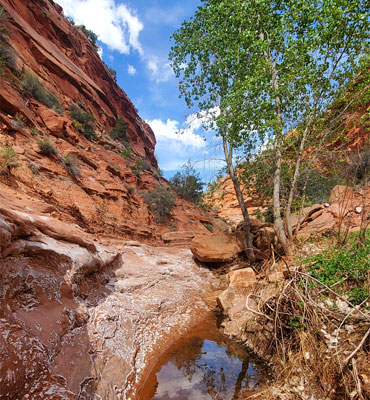
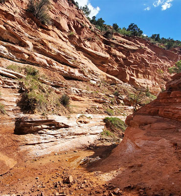
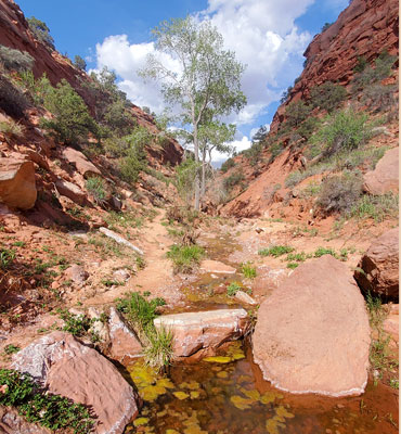
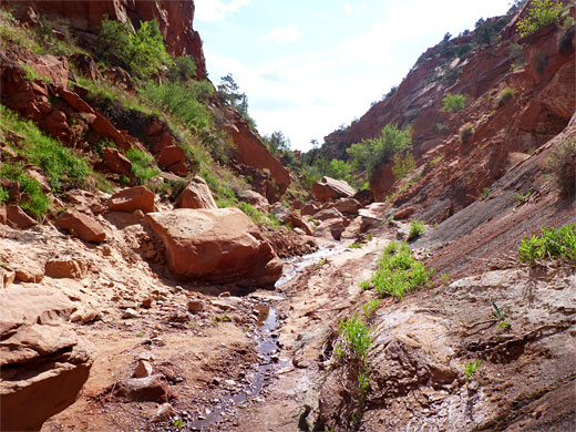
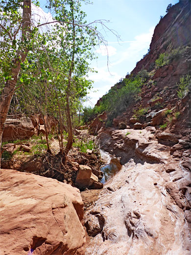
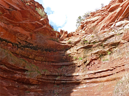
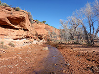
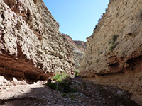
The trail is straight for a quarter of a mile, crossing a broad flat, heading towards the cliffs, which close in gradually at first then more abruptly, approaching close to a stony streambed. The path forks again just after crossing the creek - the Cliff Trail departs to the left, climbing steeply, while the canyon route runs upstream, at first alongside the creekbed then directly along it, as the walking remains easy. Cottonwood trees appear, some arranged around a designated picnic area on the south bank. The canyon floor becomes rockier and a seasonal creek flows, between shallow pools, over a few tiny cascades. The rocks are speckled with white salt crystals. The walkable canyon ends in an alcove, encircled by curving thin sandstone layers, down which water drops slowly. The floor is muddy and there is little or no vegetation on the walls, so the place is not especially photogenic, but nice enough.
The scenery is pleasant without being spectacular, and the hike is moderately popular, suitable for all times of the year, though it is suggested not to travel immediately after rains or during melting snow, since some parts pass over clay soils which become very slippery. The last third of a mile follows a seasonal stream, flowing through pools and trickling cascades, beneath large cottonwood trees; a good place to cool off during the hot summer months.
The first part of Tom's Canyon Trail skirts the edge of a recent housing development, crossing undulating ground below a sandstone ridge, a promontory off the Vermilion Cliffs; it then crosses a sagebrush flat and enters the narrower, upper section of the valley. The is no visitor parking at the trailhead, which is within the new estate; the nearest place for this is about a quarter of a mile back on other residential streets, including 300N.
Map of Tom's Canyon Trail
Start of the Trail
The Tom's Canyon hike starts beside a house on Ladera Lane, where the trailhead notice is accompanied by warnings about no visitor parking; non-resident vehicles left here will be towed away. The path very soon forks - right is the K-Hill Trail while the left branch, to the canyon, winds over little mounds and through gullies, avoiding the private land below. At one place, crossing a larger wash, it veers further upwards, to pass an extended garden. The mostly barren, clayish slopes are sprinkled with a selection of showy wildflowers such as jewel milkweed, Arizona skyrocket and rosy gilia. The a path climbs a little higher, passes over a red earth ridge and descends to a sagebrush flat, at the far edge of the housing area - the adjacent land is quite recently cleared, and there will soon be many more houses constructed in the valley. The surroundings now have rather fewer wildflowers.
The Canyon
The trail is straight for a quarter of a mile, crossing a broad flat, heading towards the cliffs, which close in gradually at first then more abruptly, approaching close to a stony streambed. The path forks again just after crossing the creek - the Cliff Trail departs to the left, climbing steeply, while the canyon route runs upstream, at first alongside the creekbed then directly along it, as the walking remains easy. Cottonwood trees appear, some arranged around a designated picnic area on the south bank. The canyon floor becomes rockier and a seasonal creek flows, between shallow pools, over a few tiny cascades. The rocks are speckled with white salt crystals. The walkable canyon ends in an alcove, encircled by curving thin sandstone layers, down which water drops slowly. The floor is muddy and there is little or no vegetation on the walls, so the place is not especially photogenic, but nice enough.
Tom's Canyon Trail - Similar Hikes

All Contents © Copyright The American Southwest | Comments and Questions | Contribute | Affiliate Marketing Disclosure | Site Map