Many Pools Canyon
Short, open, moderately steep drainage across colorful slickrock; forms many potholes, retaining water for a long time after rainfall. 500 feet west is a similar drainage, more enclosed, with a slot section near its lower end
Length: 0.9 miles, to the end of the pools; 0.3 miles for the west canyon
Elevation change: 550 feet; 200 feet
Difficulty: Easy to moderate
Type: One way, a route rather than a trail
Usage: Medium
Season: All year
Trailhead: Pullout on the south side of Hwy 9
Rating (1-5): ★★★★★
Elevation change: 550 feet; 200 feet
Difficulty: Easy to moderate
Type: One way, a route rather than a trail
Usage: Medium
Season: All year
Trailhead: Pullout on the south side of Hwy 9
Rating (1-5): ★★★★★

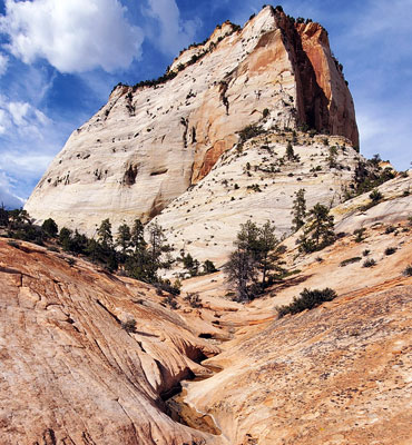
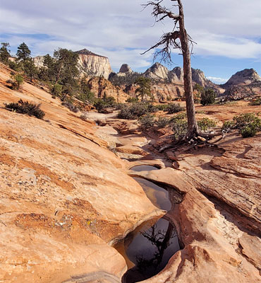
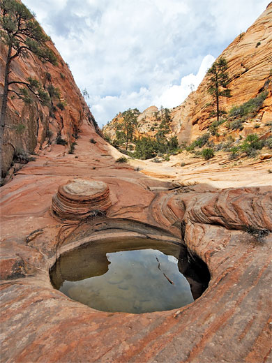
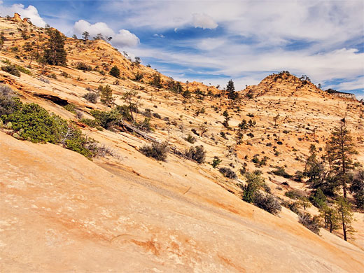
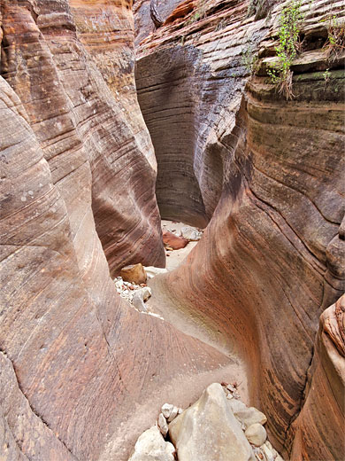
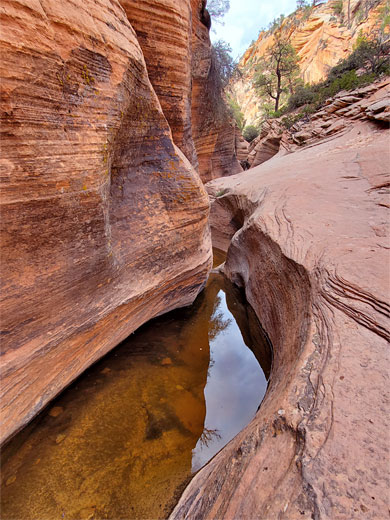
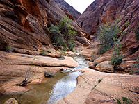
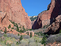
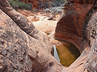
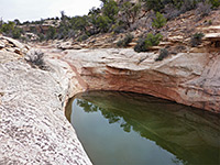
Many Pools Canyon is the unofficial, relatively recently-bestowed name of a short (1.5 mile) north-side tributary of Clear Creek, on the east side of Zion National Park, easily accessed, at its lower end, from Hwy 9. For the first 0.9 miles the canyon is open and unenclosed, the seasonal stream flowing across thin-layered Navajo sandstone slickrock, and is notable for dozens of pools, or potholes, which retain water a long time after the creek has stopped flowing; in combination with the richly-colored sandstone, the green trees and the plentiful wildflowers, this creates a very photogenic scene. The upper reaches of the drainage become enclosed in a deep, overgrown canyon, less easy or worthwhile to explore, but the lower section has become a popular hike.
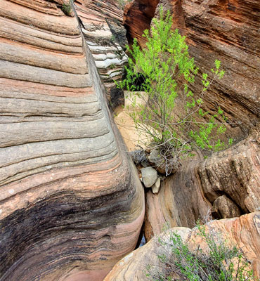
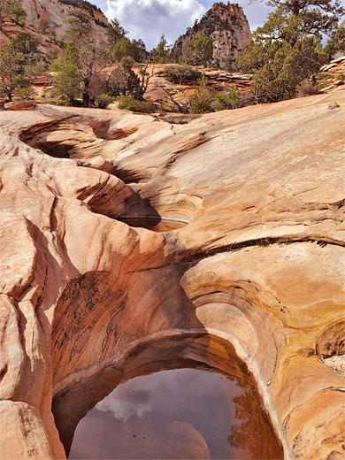
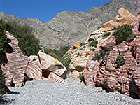
Also of interest is the adjacent, parallel drainage 500 feet west, which might be called West Many Pools Canyon. This is much more confined, with trees and dense undergrowth, but just the lower few hundred feet is relatively unobstructed, and contains a nice shallow slot through the stripy sandstone; worthy of a quick visit. The two canyons, similar in length, are alternatively known as The Twins or the Root Canals.
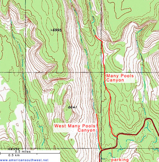
Parking for the hikes is in a large pullout on the south side of Hwy 9, 2.3 miles east of the Zion-Mt Carmel Tunnel, or 0.9 miles east of a smaller tunnel. The main canyon is about 400 feet east, the other drainage 500 feet west.
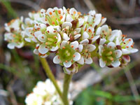
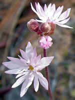
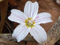
Many Pools Canyon is entered on the east side, down a short slope, joining the wash next to the tunnel under the road, a section which is fairly narrow, shaded by a few pine trees. Upstream, it opens out and soon starts climbing, up patches of inclined slickrock, separated by sandy stretches. In a few places are some bigger falls, all easily negotiated. Rocks are pale red, or whitish. Potholes become gradually more numerous further up the canyon, the best sequence after 0.6 miles, as the drainage approaches the tall white cliffs to the north. Past here the streamway soon becomes dark and enclosed, now flanked by tall trees, and containing no more pools, though it is possible to continue, climbing quite steeply up ledges and slopes at the far end of this ravine, eventually linking the Deertrap Mountain Trail. Away from the actual drainage are various seeps and other pools, harboring such unusual wildflowers as diamond-leaf pseudosaxifrage, lanceleaf springbeauty and slender woodland-star.
West Many Pools Canyon is fairly open at first, and also has a few pools in the streamway. After 800 feet the land slopes upwards and the drainage forms a nice twisting slot to the west, below a vertical cliff, also containing some potholes. Soon after it narrows, becoming overgrown, and gains height more steeply, now quite difficult to follow, and not especially pretty. In the other direction the drainage passes under the road via a long tunnel which is completely dark in the middle.
Also of interest is the adjacent, parallel drainage 500 feet west, which might be called West Many Pools Canyon. This is much more confined, with trees and dense undergrowth, but just the lower few hundred feet is relatively unobstructed, and contains a nice shallow slot through the stripy sandstone; worthy of a quick visit. The two canyons, similar in length, are alternatively known as The Twins or the Root Canals.
Parking for the hikes is in a large pullout on the south side of Hwy 9, 2.3 miles east of the Zion-Mt Carmel Tunnel, or 0.9 miles east of a smaller tunnel. The main canyon is about 400 feet east, the other drainage 500 feet west.
Many Pools Canyon Video
The Canyon
Many Pools Canyon is entered on the east side, down a short slope, joining the wash next to the tunnel under the road, a section which is fairly narrow, shaded by a few pine trees. Upstream, it opens out and soon starts climbing, up patches of inclined slickrock, separated by sandy stretches. In a few places are some bigger falls, all easily negotiated. Rocks are pale red, or whitish. Potholes become gradually more numerous further up the canyon, the best sequence after 0.6 miles, as the drainage approaches the tall white cliffs to the north. Past here the streamway soon becomes dark and enclosed, now flanked by tall trees, and containing no more pools, though it is possible to continue, climbing quite steeply up ledges and slopes at the far end of this ravine, eventually linking the Deertrap Mountain Trail. Away from the actual drainage are various seeps and other pools, harboring such unusual wildflowers as diamond-leaf pseudosaxifrage, lanceleaf springbeauty and slender woodland-star.
The West Canyon
West Many Pools Canyon is fairly open at first, and also has a few pools in the streamway. After 800 feet the land slopes upwards and the drainage forms a nice twisting slot to the west, below a vertical cliff, also containing some potholes. Soon after it narrows, becoming overgrown, and gains height more steeply, now quite difficult to follow, and not especially pretty. In the other direction the drainage passes under the road via a long tunnel which is completely dark in the middle.
Topographic Map of Many Pools Canyon
Many Pools Canyon - Similar Hikes
All Contents © Copyright The American Southwest | Comments and Questions | Contribute | Affiliate Marketing Disclosure | Site Map