Talus Canyon
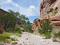
Scenic gorge through red-yellow rocks of Entrada sandstone and the Summerville Formation; wide for the first mile then narrowing to form a short slot canyon, not easily accessible but viewable from above
Length: 2 miles, to the upper end of the narrows
Elevation change: 600 feet
Difficulty: Easy to moderate
Type: One-way, mostly off-trail
Usage: Low
Season: All year
Trailhead: Orphan Mesa Picnic Area, along US 84 near Ghost Ranch
Rating (1-5): ★★★★★
Elevation change: 600 feet
Difficulty: Easy to moderate
Type: One-way, mostly off-trail
Usage: Low
Season: All year
Trailhead: Orphan Mesa Picnic Area, along US 84 near Ghost Ranch
Rating (1-5): ★★★★★

Talus Canyon, or Ladrone Canyon, are unofficial names of a short drainage through colorful rocks on the south side of Mesa Del Yeso, in the Carson National Forest of northern New Mexico, of interest for some photogenic rock formations that rise above the streambed, while just to the north is an adjacent ravine, much narrower and enclosed; a slot canyon. The location is easily accessed from a picnic place along US 84, 11 miles northwest of Abiquiu, and 1.6 miles east of the turn-off to the famous Ghost Ranch, latterly home to Georgia O'Keeffe.
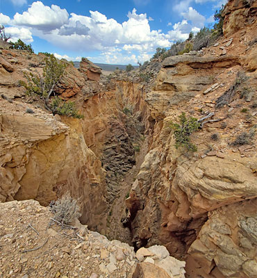
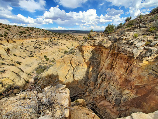
Both canyons may be explored on a hike of 2 miles - up the lower drainage, across a short open area to the start of the narrows, which are soon blocked by a few boulders and dryfalls so it is not generally possible to proceed very far, however the narrows may be viewed from above by walking along the rim for a third of a mile to the far end, where the gorge becomes shallow again.
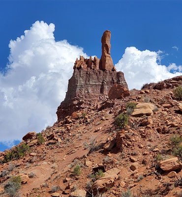
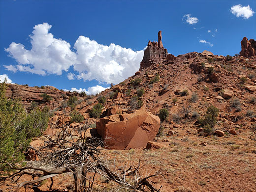
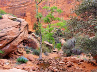
Rocks around the slot section are Entrada sandstone, and this also forms the higher elevations of the sides of the lower gorge, including a distinctive pinnacle known as Kokopelli Rock, or Talus Spire. Below this, forming the more sloping terrain closer to the streambed, are thin-layered sandstone and conglomerate from the Poleo Formation, a subunit of the Chinle Formation.
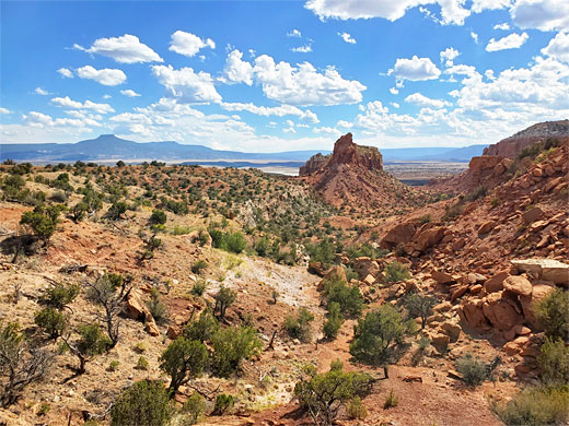
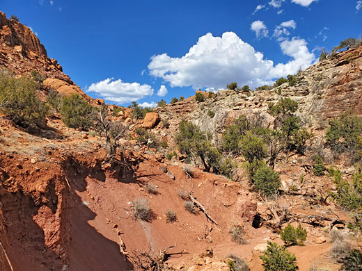
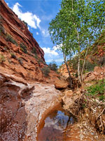
Orphan Mesa Picnic Area provides an ideal parking place for the hike into Talus Canyon - on the south side of US 84, looking south across open ground that slopes gently down towards Abiquiu Reservoir, along Rio Chama. A red cliff rises to the north, on the opposite side of the road, and near the top is a slender, elongated arch, not that easy to spot, named Eye of the Needle, or Talus Natural Arch. The hike starts at the base of the cliff, heading east, through a fence, over bushy land for a few hundred feet then down into the wide, sandy streambed of the canyon, which is followed northwards, sometimes using the little paths to cut off bends. Kokopelli Rock, sitting atop a narrow fin, is passed on right then soon after, the streambed gains height, the cliffs recede and after a short, steep climb, the path is now crossing a strip of flat land which separates this canyon from the adjacent drainage containing the narrows.
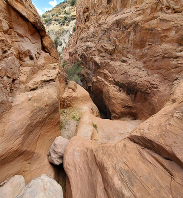
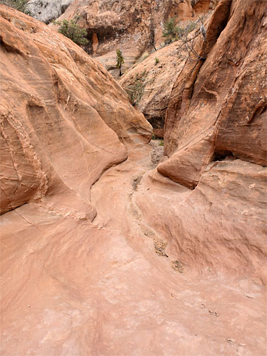
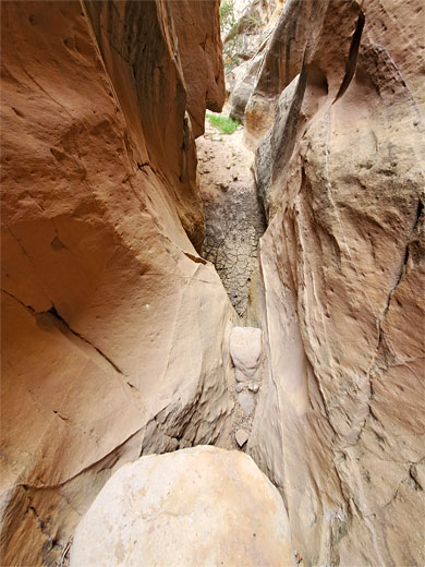
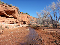
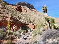
The faint path continues, past a low red cliff, round a bend to a brief enclosed passage, with boulder and dryfall, the rocks quite smooth but climbable via some natural footholds. The streambed opens again briefly then narrows once more, now enclosed by much taller cliffs. It passes through a V-shaped pour off, above which is a muddy hole below a bigger dryfall, topped by a large boulder, this not easily climbable. Instead, the narrows can be viewed from above by climbing the overgrown, stony and bushy slopes on the east side and following the rim; care is needed as much of the rock hereabouts is loose and crumbling. At the upstream end of the narrows is another unclimbable fall so the slot cannot even be entered from above.
Both canyons may be explored on a hike of 2 miles - up the lower drainage, across a short open area to the start of the narrows, which are soon blocked by a few boulders and dryfalls so it is not generally possible to proceed very far, however the narrows may be viewed from above by walking along the rim for a third of a mile to the far end, where the gorge becomes shallow again.
Rocks around the slot section are Entrada sandstone, and this also forms the higher elevations of the sides of the lower gorge, including a distinctive pinnacle known as Kokopelli Rock, or Talus Spire. Below this, forming the more sloping terrain closer to the streambed, are thin-layered sandstone and conglomerate from the Poleo Formation, a subunit of the Chinle Formation.
The Lower Canyon
Orphan Mesa Picnic Area provides an ideal parking place for the hike into Talus Canyon - on the south side of US 84, looking south across open ground that slopes gently down towards Abiquiu Reservoir, along Rio Chama. A red cliff rises to the north, on the opposite side of the road, and near the top is a slender, elongated arch, not that easy to spot, named Eye of the Needle, or Talus Natural Arch. The hike starts at the base of the cliff, heading east, through a fence, over bushy land for a few hundred feet then down into the wide, sandy streambed of the canyon, which is followed northwards, sometimes using the little paths to cut off bends. Kokopelli Rock, sitting atop a narrow fin, is passed on right then soon after, the streambed gains height, the cliffs recede and after a short, steep climb, the path is now crossing a strip of flat land which separates this canyon from the adjacent drainage containing the narrows.
The Upper Canyon
The faint path continues, past a low red cliff, round a bend to a brief enclosed passage, with boulder and dryfall, the rocks quite smooth but climbable via some natural footholds. The streambed opens again briefly then narrows once more, now enclosed by much taller cliffs. It passes through a V-shaped pour off, above which is a muddy hole below a bigger dryfall, topped by a large boulder, this not easily climbable. Instead, the narrows can be viewed from above by climbing the overgrown, stony and bushy slopes on the east side and following the rim; care is needed as much of the rock hereabouts is loose and crumbling. At the upstream end of the narrows is another unclimbable fall so the slot cannot even be entered from above.
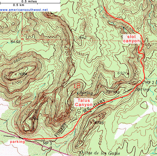
Topo Map of Talus Canyon
Talus Canyon Wildflowers
More flowers in the canyon
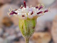 Fineleaf hymenopappus |
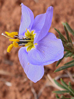 Bluebowls |
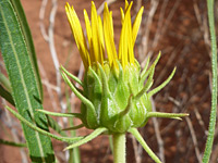 Badlands mule-ears |
More flowers in the canyon
Talus Canyon - Similar Hikes
All Contents © Copyright The American Southwest | Comments and Questions | Contribute | Affiliate Marketing Disclosure | Site Map