State Parks in California
Other California listings: national parks, monuments, recreation areas and historic sites and state natural reserves.
| Park | Features | Location |
| Ahjumawi Lava Springs State Park | Bays, creeks and tiny islands, surrounded by lava flows. Park reachable only by boat | Shasta County, near McArthur and Burney |
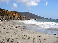
| Andrew Molera State Park | Big Sur coastline, meadows and inland redwood forests | Along Hwy 1, 20 miles south of Carmel |
| Angel Island State Park | Forested island in San Francisco Bay, with several historic buildings | Accessed by ferry from San Francisco, Vallejo or Tiburon |
| Annadel State Park | Meadows and wooded hills, with many trails | Sonoma Mountains, east of Santa Rosa along US 101 |
| Año Nuevo State Park | Island and undeveloped stretch of the coastline, providing a variety of wildlife habitats | San Mateo County, 55 miles south of San Francisco |
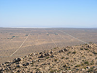
| Anza-Borrego Desert State Park | California's largest state park - rugged desert wilderness, cacti, wildflowers, oases, badlands, narrow canyons and mountains | East of San Diego, near the Salton Sea |
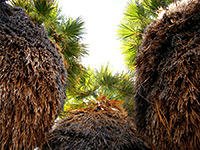
| Arthur B. Ripley Desert Woodland State Park | Joshua trees and juniper bushes | Antelope Valley, near Lancaster |
| Bidwell-Sacramento River State Park | River lined by dense woodland, popular for fishing and boating | Five miles west of Chico, Butte County |
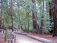
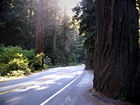
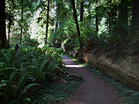
| Big Basin Redwoods State Park | Atmospheric old growth redwood forest | In the hills southwest of Santa Cruz |
| Border Field State Park | Salt marshes and sand dunes, home to several rare bird species | South of San Diego, adjoining the Mexican border |
| Bothe-Napa Valley State Park | Coastal redwoods and small streams - hiking and horse riding available | Napa Valley, between Calistoga and St Helena |
| Burton Creek State Park | Hiking and skiing through forested terrain | Tahoe City, Lake Tahoe |
| Butano State Park | Shady mountain canyon with redwood trees | Near Pescadero, west of Santa Cruz |
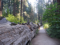
| Calaveras Big Trees State Park | Giant sequoia in the northern Sierra Nevada | Along CA 4, 20 miles northeast of Angels Camp |
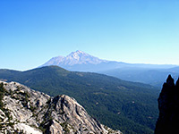
| Castle Crags State Park | Granite rock formations and a section of the Sacramento River | Near Mt Shasta, just off interstate 5 |
| Castle Rock State Park | Mixed fir/redwood forest and rock formations, along the top of the Santa Cruz Mountains; many trails | CA 35, a few miles from Santa Cruz |
| Caswell Memorial State Park | Oak woodland and riparian habitats beside the Stanislaus River | South of Stockton, near Hwy 99 |
| China Camp State Park | Marsh, oak woodland and meadows beside San Pablo Bay | Peninsula just northeast of San Rafael |
| Chino Hills State Park | Grassy hills, patches of woodland, spring wildflowers; 60 miles of trails | Ten miles northwest of Corona, Orange County |
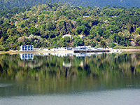
| Clear Lake State Park | Wooded section of the shoreline of 43,785 acre Clear Lake | West side of the lake, a few miles from Lakeport |
| Crystal Cove State Park | Sandy beaches, tidepools and undeveloped woodland, plus an undersea park open for scuba diving | Between Newport Beach and Laguna Beach, Orange County |
| Cuyamaca Rancho State Park | Pine/oak woodland, grassy hills, meadows and small streams - over 100 miles of trails | Cuyamaca Mountains, northeast of San Diego |
| D. L. Bliss State Park | Forest and promontory on the west shore of Lake Tahoe | Ten miles north of South Lake Tahoe |
| Del Norte Coast Redwoods State Park | Tall but rather inaccessible redwoods adjoining the Pacific Ocean | Part of Redwood National and State Parks - near Crescent City |
| Donner Memorial State Park | Wooded land next to Donner Lake, with museum and relics from the Donner Party | On the edge of Truckee, close to I-80 |
| Ed Z'berg Sugar Pine Point State Park | Historic mansion on the west shore of Lake Tahoe, surrounded by pine forest | 18 miles north of South Lake Tahoe |
| Emerald Bay State Park | Beautiful inlet on the west shore of Lake Tahoe, containing Fannette Island; also has a reproduction Viking castle | Nine miles north of South Lake Tahoe |
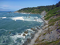
| Estero Bluffs State Park | Coastal hills, cliffs, wetlands and secluded beaches - varied plant and wildlife habitats | Along Hwy 1 between Morro Bay and Cambria |
| Fort Ord Dunes State Park | Bluffs and a sandy beach | Seven miles north of Monterey, just off CA 1 |
| Fremont Peak State Park | Grasslands and wooded hills in the Gabilan Range, with views of Monterey Bay | Near Salinas, Hollister and San Juan Baptista |
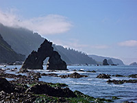
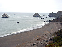
| Garrapata State Park | Beaches and rock formations on the Big Sur coast | Seven miles south of Carmel along Hwy 1 |
| Gaviota State Park | Beach, pier and grassy hills overlooking the Channel Islands | 30 miles west of Santa Barbara via US 101 |
| Great Valley Grasslands State Park | Grassland and marshes in the Central Valley; few visitor facilities | Hwy 165, 28 miles south of Modesto |
| Grizzly Creek Redwoods State Park | Two small groves of coastal redwoods beside a winding river | Hwy 36, Humboldt County, 37 miles from Eureka |
| Grover Hot Springs State Park | Pine forest and meadows, plus a swimming pool fed by hot springs | In the eastern Sierra Nevada, 34 miles from South Lake Tahoe |
| Harmony Headlands State Park | Grassy hills and eroded sandstone formations beside the Pacific Ocean; limited facilities | Along Hwy 1 between Morro Bay and Cambria |
| Hearst San Simeon State Park | Two sections; coastal bluffs alongside the Pacific Ocean, and Hearst Castle, the extravagant home of William Randolph Hearst | CA 1, north of Cambria |
| Hendy Woods State Park | Two redwood groves beside the Navarro River | Anderson Valley, Mendocino County - 27 miles from Ukiah |
| Henry Cowell Redwoods State Park | Trails an through ancient redwood forest | Along Hwy 9, north of Santa Cruz |
| Henry W. Coe State Park | Large, undeveloped area of hills, ridges, valleys and forest | East side of Santa Clara Valley, near Morgan Hill |
| Humboldt Lagoons State Park | Coastal lagoons and long, windswept beaches | US 101, near Redwood National Park |
| Humboldt Redwoods State Park | Large area of dense forest, with many huge old growth redwoods | US 101, 45 miles south of Eureka |
| Jedediah Smith Redwoods State Park | Scenic redwood forest along the Smith River | Part of Redwood National and State Parks - near Crescent City |
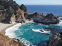
| Julia Pfeiffer Burns State Park | Pretty section of the Big Sur coastline, bordered by steep, wooded hills | Hwy 1, 38 miles south of Carmel |
| Leo Carrillo State Park | Pacific Ocean beach, part of Santa Monica Mountains NRA | Hwy 1, 28 miles from Santa Monica |
| Limekiln State Park | Small part of the Big Sur coast plus a few miles of Limekiln Creek and an adjacent redwood forest | Hwy 1, 53 miles south of Carmel |
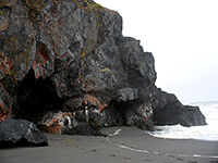
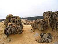
| MacKerricher State Park | Variety of coastal landscapes including dunes, tidepools and eroded rock formations | Hwy 1, just north of Fort Bragg, Mendocino County |
| Malibu Creek State Park | Oak, sycamore and chaparral hills either side of a wide, shallow stream | Four miles south of US 101 - part of Santa Monica Mountains NRA |
| Manchester State Park | Long beach with sand dunes, next to Point Arena | Hwy 1, Mendocino County |
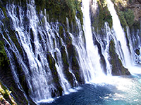
| McArthur-Burney Falls Memorial State Park | Spectacular cascade waterfall in wooded country adjacent to Lake Britton | Shasta National Forest, north of Lassen Volcanic National Park |
| Mendocino Headlands State Park | Beaches, cliffs and grassy hills overlooking the Pacific Ocean | Either side of Mendocino, just off Hwy 1 |
| Mendocino Woodlands State Park | Group campsite and environmental learning center in second growth redwood forest | Seven miles east of Mendocino |
| Montaña de Oro State Park | Beaches, cliffs and a sizeable hilly area along the Pacific coast | South of Morro Bay and west of San Luis Obispo |
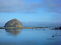
| Morro Bay State Park | Hills, marsh, beach and coastal wetlands, plus the conspicuous landmark of Morro Rock | Morro Bay, San Luis Obispo County |
| Mount Diablo State Park | Scenic, forested mountain - many trails and viewpoints | East of Concord and I-680 |
| Mount San Jacinto State Park | Granite summit and cool pine forests high above Palm Springs and the Coachella Valley | Hwy 243 through the San Bernardino National Forest; also reached by the Palm Springs Aerial Tramway |
| Mount Tamalpais State Park | Redwood groves surrounded by oak-covered hills; many miles of trails, and views over San Francisco Bay | West of Mill Valley, along US 101 |
| Navarro River Redwoods State Park | Second growth redwood trees along the Navarro River, ending at a small beach by the ocean | Hwy 128, 20 miles south of Fort Bragg, Mendocino County |
| Pacheco State Park | Grassy hills and floral meadows with fine views over the Central Valley | 14 miles from interstate 5, near Los Banos |
| Palomar Mountain State Park | Cool, forested mountain; hiking, camping and fishing are available | Cleveland National Forest - off Hwy 76, southeast of Temecula |
| Pfeiffer Big Sur State Park | Several miles of land in the forested canyon of the Big Sur River, including groves of coastal redwoods | Hwy 1, 28 miles south of Carmel |
| Placerita Canyon State Park | Hilly country with streams and oak woodland; contains site of the first gold to be discovered in California (1842) | North of San Fernando, close to the 14 Freeway |
| Plumas-Eureka State Park | Forested hills in the northern Sierra Nevada, plus museum and relics from the gold mining era | Five miles from Blairsden/Graeagle, on Hwy 89 |
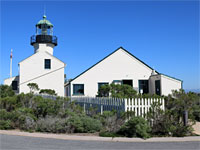
| Point Cabrillo Light Station State Historic Park | Grassy peninsula along the Mendocino Coast, home to a historic lighthouse | Between Mendocino and Fort Bragg, just off Hwy 1 |
| Point Mugu State Park | Beaches, bluffs, hills and sand dunes alongside the Pacific Ocean | Hwy 1, 30 miles from Santa Monica - part of Santa Monica Mountains NRA |
| Portola Redwoods State Park | Redwood, fir and oak trees covering hilly terrain in the Santa Cruz Mountains | 30 miles west of San Jose |
| Prairie Creek Redwoods State Park | The best collection of giant redwood trees in California | Part of Redwood National and State Parks - near Crescent City |
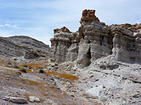
| Red Rock Canyon State Park | Colorful, eroded rock formations at the edge of the Mojave Desert | Hwy 14, 27 miles from Ridgecrest |
| Richardson Grove State Park | Coastal redwoods along the South Fork of the Eel River - southernmost of the old growth redwood parks | US 101, Humboldt County |
| Robert Louis Stevenson State Park | Wooded hillsides just north of Napa Valley - honeymoon location for the famous author | Five miles from Calistoga on Hwy 29 |
| Russian Gulch State Park | Beach, rocky headland and a forested river canyon | Hwy 1, Mendocino County, near Fort Bragg |
| Saddleback Butte State Park | Mojave Desert peak surrounded by a forest of Joshua trees | 11 miles north of Hwy 138, near Palmdale |
| Salt Point State Park | Pacific Ocean beaches, bluffs, forest, grassland and amazing rock formations | Hwy 1, Sonoma County |
| Samuel P. Taylor State Park | Hilly country with coastal redwoods and grasslands, good for hiking | Just off Hwy 1, near Point Reyes |
| San Bruno Mountain State Park | Undeveloped grassy ridge rising above San Francisco and its suburbs - summit has excellent views | Accessed from US 101 or I-280 |
| Sinkyone Wilderness State Park | Remote wilderness bordering the Pacific Ocean - part of the Lost Coast | 25 miles from US 101 via winding mountain roads; in Mendocino County |
| Sonoma Coast State Park | Collection of beaches, coves and cliffs extending for 15 miles along the Pacific Coast of Sonoma County | Hwy 1, between Bodega Bay and Jenner |
| South Yuba River State Park | 20 mile stretch of the Yuba River as it flows through a rocky, forested canyon. Includes a historic covered bridge | East of Bridgeport, in the western Sierra Nevada foothills |
| Sue-meg (Patricks Point) State Park | Thickly wooded promontory, tide pools and Pacific Ocean beaches | US 101, near Redwood National Park |
| Sugarloaf Ridge State Park | Wooded mountains with streams, eroded rocks, meadows and chaparral; 25 miles of trails | Seven miles east of Santa Rosa, Sonoma County |
| Sutter Buttes State Park | Lava flows on the north side of a volcanic dome. Park is not yet open | 15 miles northwest of Yuba City |
| The Forest of Nisene Marks State Park | Second growth redwoods and steep-sided coastal mountains, with relics from former logging operations | North of Aptos, along Hwy 1 - near Santa Cruz |
| Tolowa Dunes State Park | Wetlands and sand dunes bordering the Pacific Ocean - diverse wildlife habitats | Two miles north of Crescent City |
| Tomales Bay State Park | Shallow bay adjacent to Point Reyes - site of the San Andreas Fault | Hwy 1, Marin County |
| Topanga State Park | Hilly land with oak woodland and grassy meadows - part of Santa Monica Mountains NRA | East side of Hwy 27 between CA 1 and the San Fernando Valley |
| Van Damme State Park | Wooded canyon with abundant ferns and unusual plants, leading to a beach on the Pacific Ocean | Three miles south of Mendocino, along Hwy 1 |
| Washoe Meadows State Park | Forest and meadows along Angora Creek, once home to Native American tribes. Park is not yet developed | Two miles from South Lake Tahoe |
| Wilder Ranch State Park | Historic ranch surrounded by extensive grassland and forest, plus riparian habitats and a section of coastline | West of Santa Cruz along Hwy 1 |
All Contents © Copyright The American Southwest | Comments and Questions | Contribute | Affiliate Marketing Disclosure | Site Map