Highlights:
Beautiful, unspoilt, seven mile section of the southern California coastline near Los Osos, with eroded rock formations, small beaches, grassy bluffs and hills up to 1,600 feet
Nearby town:
Morro Bay, 9 miles
Management:
Location:
35.274, -120.886 (Spooner Ranch House)
Seasons:
All year
Rating (1-5):
★★★★★
Weather:


Montaña de Oro SP is part of the California South Coast itinerary
Featured Hotel
Best Western Tradewinds Motel
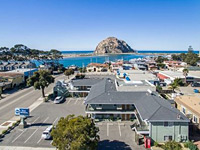 Small (24 room) motel near the shoreline of Morro Bay, close to the shops and restaurants of the town center. Ten miles from Montaña de Oro SP
Check Rates
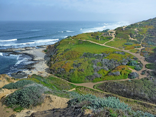
Many of the coastal state parks in California are relatively tame and often quite developed, popular because of the beaches and visitor facilities rather than the natural scenery. But not so Montaña de Oro, at 8,000 acres one of the largest state parks, which includes a seven mile stretch of rocky or sandy coastline, mountains up to 1,649 feet, sand dunes, several deep valleys and extensive coastal bluffs.
A paved road crosses the whole park, close to the ocean, so shoreline access is easy, and this, combined with the excellent scenery, a pleasant campground and many trails make the place often rather busy, with over half million people coming here each year.
The ambience is not as peaceful as some more remote places like the Lost Coast or the Harmony Headlands, but Montaña de Oro State Park is still one of the highlights of California's southern coastline. The name of this area ('mountain of gold') was bestowed by Irene McAllister, an early resident, in reference to the numerous California poppies that bloom in the spring.
Montaña de Oro Table of Contents
Photographs
40 views of Montaña de Oro State Park, 44 views of wildflowers in the park.
Video
Rock formations near Hazard Reef.
Introduction
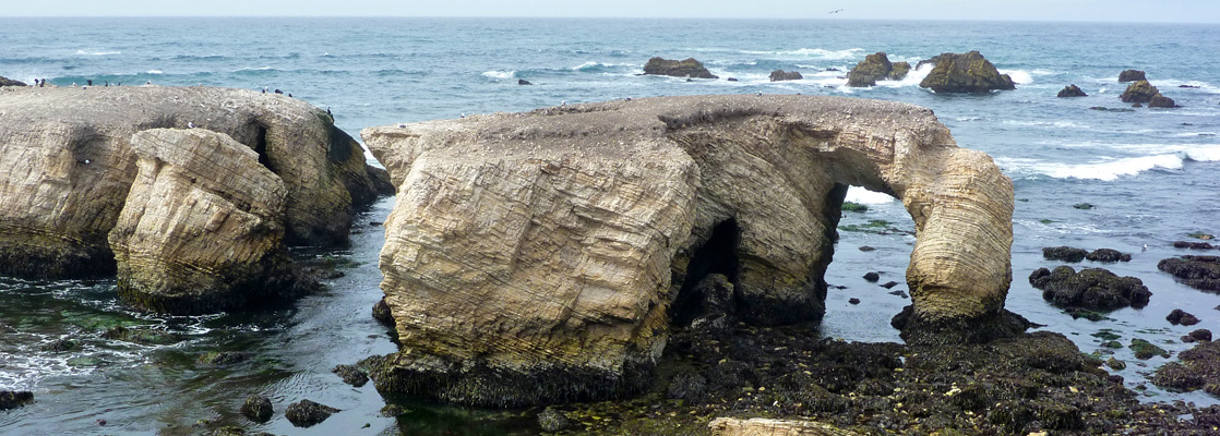
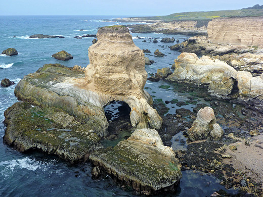
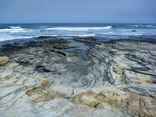
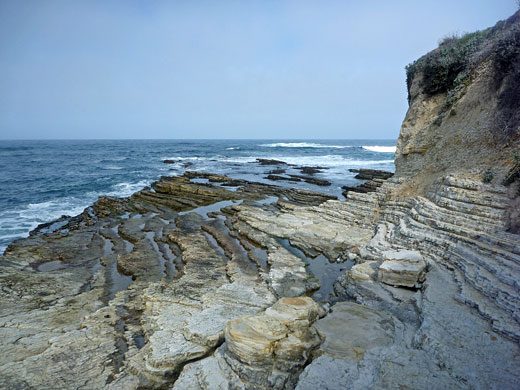
Like many other locations along the Pacific coast, the hills, ravines, dunes and bluffs have their own appeal, but the best part of the landscape is the rocky shoreline, divided into inlets, arches and promontories, with many sea stacks just offshore. Also in common with other places, the bedrock is sedimentary, formed of many thin, parallel layers, inclined by geological faulting, and then carved by the water into a great variety of forms, both angular and rounded. Extensive tidepools are found amongst the marine terraces and gullies, though some places are sandy, including Spooner's Cove - the largest beach in the area and the center of most visitor services - and the northern section of the park, where big dunes stretch for several miles, separating the ocean from the sheltered waters of Morro Bay.
Access
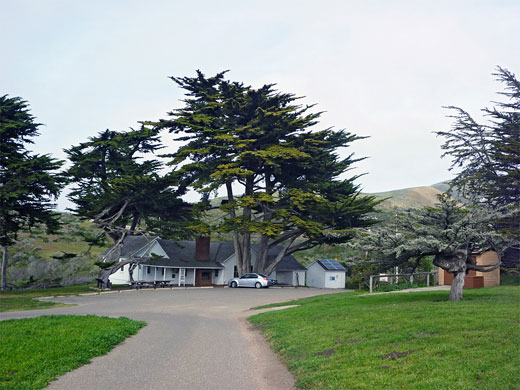
Montaña de Oro State Park can be approached from the east, along Los Osos Valley Road from San Luis Obispo, or from the north, via Bay Boulevard from Morro Bay. These two routes meet, and the former continues a couple of miles through the residential community of Los Osos then becomes narrow and winding once over the park boundary (there is no fee to enter), and the ocean comes into view. The road passes through a few groves of trees, growing in a sheltered ravine; one contains eucalyptus, a non-native species planted by early settlers in the mistaken belief that the timber would be commercially viable. After starting quite high the road descends somewhat, leveling out at about 100 feet above the ocean and staying around half a mile from the shore; the only closer approach is at Spooner's Cove, location of a 47-site campground, store, wildlife garden and historic ranch building. Past here the road extends another 2 miles, past several trailheads to a parking area just before a gate that marks the boundary between the park and the extensive private holdings of Pacific Gas and Electric Company, who operate a secretive nuclear power plant 4 miles south at Diablo Canyon. Limited pedestrian access to another few miles of the coastline is permitted, however.
The Montaña de Oro Coastline
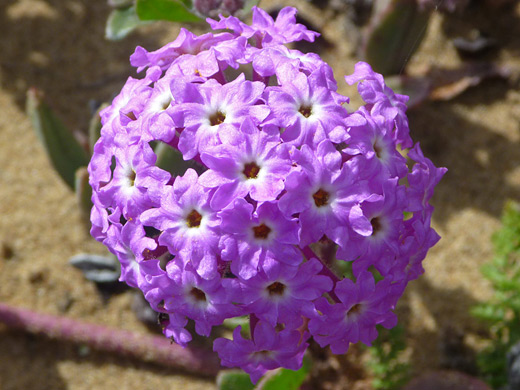
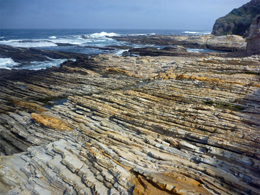
The northern section of the coastline in the state park is less interesting, mostly just grassy dunes bordering a long, unchanging sandy beach, which may be seen by several trails starting at the end of a short spur (Sand Spit Road). The coast becomes increasingly rocky and photogenic further south; the first rocks are around a small promontory (Hazard Reef), reached by a very short trail from a shady parking area one mile beyond the Sand Spit turn off. The reef is representative of all formations in the park, which range from flat, level terraces, ideal for walking across, to vertical cliffs guarding inaccessible coves, and all angles in between. The component strata are inclined, and thin-layered; the most characteristic erosion behavior is to form long, thin spits perpendicular to the shore, with narrow inlets in between. The color of the sedimentary rocks (Miguelito shale) ranges from nearly white to orange and light brown, becoming much darker below the high water mark. There is no tafoni (small scale, honeycomb-like erosional structures) unlike some otherwise similar areas like Salt Point State Park or Shore Acres State Park. A few dozen species of native wildflowers grow along the shoreline though the most widespread are the invasive ice pants, both pink and yellow flowered varieties.
Rocky Shores
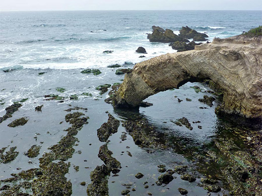
South of Hazard Reef, the coast is for about two thirds of a mile bordered by flat terraces and long, straight, low cliffs, with rock pools and pebble beaches, then beyond are two non-traversable deepwater inlets, soon after which the coast curves inwards to the 1,000-foot wide sands at Spooner's Cove. Several trails start near here including the popular climb to the summit of Valencia Peak, one of four major hills in the park, and the closest to the ocean. The cliffs return on the south side of the beach, soon split by two much smaller inlets (Corallina Cove and Quarry Cove), and are then eroded into a succession of promontories and narrow channels, the first part of which is viewable by the northern half of the Bluffs Loop Trail. The land is rather less visited beyond, as the varied formations continue another half mile to the south edge of the state park, and include a big isolated sea stack with a cave through the base, and a thin, angular natural bridge. The cliffs hereabouts are generally higher than before, and most of the waterline is not accessible; the few climb down points are generally only to lower benches still a little way above the ocean. The last part of the shoreline trail bends inland above a railing-protected beach, following a stream (Coon Creek) to the south end of the park road.
Point Buchon
A section of the coast south of the state park is accessible for several days a week between 9 am and 4 pm, when a continuation path is open - through the gate at the entrance to the Pacific Gas and Electric complex, over Coon Creek and up to an entrance station where visitors are acquainted with the many rules and regulations, in particular the need to return here by 3:45 pm at the latest, and to stay on the trail at all times - no climbing down to beaches or rocks allowed here (apart from at the mouth of Coon Creek). Guards patrol the area on ATVs just to make sure. The public trail winds southwards another 5 miles but most visitors just make a short one mile loop near the entrance station, visiting a fenced off sinkhole and the wildflower-clad promontory of Point Buchon, the westernmost part of this section of the coast. There are several other good arches and rock formations in between these two places. The shoreline gradually becomes less rocky further south, and the inland terraces are flatter and more grassy.
Hiking at Montaña de Oro State Park
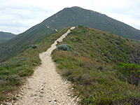
Valencia Peak Trail
★★★★★
★★★★★
1.9 miles, 1290 feet
Hike up open slopes to a 1,347 foot summit just over one mile from the Pacific Ocean, giving good views up and down the coast, and inland over many more rolling, grassy hillsMontaña de Oro - Nearby Places
- Estero Bluffs State Park (20 miles) - coastal terraces bordering empty beaches
- Morro Bay State Park (10 miles) - varied coastal environments around the picturesque town of Morro Bay
Montaña de Oro - Similar Places
- Lost Coast - wildest and least accessible stretch of California's Pacific coastline
- Sonoma Coast State Park - beaches and cliffs in north California
All Contents © Copyright The American Southwest | Comments and Questions | Contribute | Affiliate Marketing Disclosure | Site Map