Goldstrike Canyon, Lake Mead National Recreation Area
Arizona > Lake Mead National Recreation Area > Goldstrike Canyon
Goldstrike Canyon
Deep, twisting ravine that meets the Colorado River (Lake Mohave) one mile below the Hoover Dam, containing various pools, waterfalls and hot springs, and also many obstructions formed by chutes and boulders. Short ropes are installed in at least five places
Length: 2.5 miles
Elevation change: 940 feet
Difficulty: Moderate to strenuous; requires scrambling and climbing up/down obstacles
Type: One way, off-trail
Usage: Medium to high
Season: Fall, winter, spring; summers are very hot, and access may be closed
Trailhead: End of a 0.3 mile track, south of US 93
Rating (1-5): ★★★★★

There are at least six groups of hot springs along the upper reaches of Black Canyon, the cliff-bound section of the Colorado River below the Hoover Dam, of which two may be reached by recognised routes - Arizona Hot Springs on the Arizona side of the river, and the springs in Goldstrike Canyon, on the Nevada side. This twisty ravine drops nearly 1,000 feet over 2.5 miles, through jagged, weathered and often colorful rocks, joining the river one mile from the base of the dam; out of sight due to a slight bend, though in full view of the new US 93 bypass bridge.
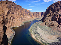
The river - also the northernmost end of Lake Mohave - is filled by beautifully clear, cold, greenish-blue water, and the confluence of Goldstrike Canyon would be a fine hiking destination on its own, but the ravine itself is also quite spectacular, in part due to the various falls, boulders and narrow sections along the way, and because of the hot springs, which sustain a pretty stream that flows through the lower half mile, and also form strange, multicolored, algae-coated mineral deposits along parts of the canyon walls.
Although part of Lake Mead National Recreation Area, Goldstrike Canyon is not promoted by the NPS as a hiking destination, yet it is exceedingly popular, visited by hundreds of people per day during cooler times of the year. The lack of publicity is due to the difficult conditions; a trip through the full length of the canyon requires descending various obstacles, at least five of which have ropes to aid the descent, plus lengthy scrambling on rough terrain. There is no reliable drinking water anywhere in the canyon, and the place is especially inhospitable during the summer, when temperatures can exceed 110 °F, and conditions are made even more extreme by the confined, shadeless environment of the canyon floor.
A typical year sees several dozen incidents where hikers require rescue or other assistance, and there have been a number of fatalities in recent times. In 2014, the park service prevented all access to the canyon during August because of the heat, and summer closures are now implemented every year. Nonetheless, in cooler conditions, the round-trip can be done by experienced hikers in not much more than two hours, and without using any of the ropes, since all obstacles are relatively easily freeclimbable, for the suitably qualified.
Map of Lake Mead National Recreation Area.
33 views of Goldstrike Canyon and Lake Mohave.
The unsigned trailhead for Goldstrike Canyon is reached from US 93, leaving at the same place (exit 2) as used for visitors to the Hoover Dam, who travel there via the original course of the highway, to the north. To the south, a paved road goes short distance and then forks, both branches unpaved; the right track is to various nearby destinations in the Black Mountains, while left is to the trailhead, the track extending just 0.3 miles, marked by a sign stating 'Goldstrike Canyon Road, 4x4 recommended' - though apart from a step at the end of the paved section, the route is relatively fine and all vehicles should be able to reach the far end. Parking is on verges, and at busy times of the day, the line of vehicles may extend much of the way back to the junction near the highway.
The short approach track leads down the very upper section of the canyon, up to a row of boulders that prevent vehicles driving any further. The hiking route proceeds down the streambed, which is formed of loose gravel and rocks, between low, weathered, reddish cliffs. The drainage stays close to US 93 for a little while, past a set of concrete supports for one of its bridges, then bends away to the south, though the traffic remains remains audible for another ten minutes or so. Helicopter noise is also often encountered, throughout the whole canyon. The streambed contains a few large iron items washed down by occasional floods. Like most of the canyon, this initial section is in shade early in the morning, but receives full sun for most of the day.
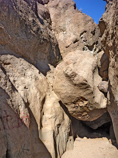
A few bends are followed by a straighter, more open section and the first minor obstacle, a big boulder, passed on the left. Next is a briefly more enclosed passage as the ravine moves through a tight bend, another sunny part where two tributaries join, and then the next obstruction, a larger chokestone passed by steps carved into the cliff face to the right - the first location where a rope is provided, though here it is perhaps not really necessary. Past this are several more chutes and isolated boulders, and a bigger slope covered by jumbled rocks, some very large, and another two places where ropes are installed. Below this slope the ground is moister and seeps start to appear, closely followed by the first group of hot pools (Goldstrike Hot Springs), the main pool located below the north wall of the canyon, its water deepened via a constructed wall. Litter is strewn about, including remains of fire rings. The vegetation in the canyon is generally rather limited; the most abundant plant is probably desert rock nettle, while other species include California suncup, desert rock daisy and southwestern mock vervain. In at least one location a young palm tree has become established.
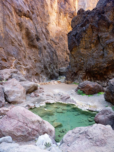
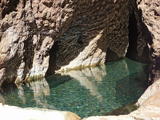
The canyon proceeds with a little waterfall, pool and cascade, the recommended route being down the stone slab on the right side, rope-assisted, but climbing directly down the streamway seems easier. The creek now flows the remainder of the way to the river. Below the fall is a particularly clear-water pool (known as Cave of Wonders), producing nice ripples on the textured rocks just above. Maidenhair ferns and other plants grow in some places along the walls, in moist alcoves. The canyon floor has a larger drop - the most difficult obstacle to overcome if not using a rope - soon after which the ravine flattens out and the stream forms many more pools and small falls, lined by hanging gardens and also in some places by strange, colorful depositional features, partly covered by algae. Above one of these is an elongated sheet waterfall, the waters noticeably warm. This lower group of thermal features is the Nevada Hot Springs, and produces water up to 122 °F.
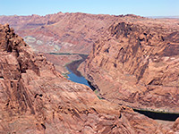
The stream below the final waterfall empties into the Colorado, and the warmth extends a few feet into the river. The confluence is bordered by a small gravel beach and some benches, but the river shoreline is generally inaccessible due to steep cliffs, though low water levels allow walking north or south a short distance. The lower end of Goldstrike Canyon is also frequently visited by rafters and canoeists, launching from the base of the Hoover Dam. A notice warns against drinking any of the water in the canyon, due to the possible presence of naegleria fowleri, a harmful microorganism.
The river - also the northernmost end of Lake Mohave - is filled by beautifully clear, cold, greenish-blue water, and the confluence of Goldstrike Canyon would be a fine hiking destination on its own, but the ravine itself is also quite spectacular, in part due to the various falls, boulders and narrow sections along the way, and because of the hot springs, which sustain a pretty stream that flows through the lower half mile, and also form strange, multicolored, algae-coated mineral deposits along parts of the canyon walls.
Although part of Lake Mead National Recreation Area, Goldstrike Canyon is not promoted by the NPS as a hiking destination, yet it is exceedingly popular, visited by hundreds of people per day during cooler times of the year. The lack of publicity is due to the difficult conditions; a trip through the full length of the canyon requires descending various obstacles, at least five of which have ropes to aid the descent, plus lengthy scrambling on rough terrain. There is no reliable drinking water anywhere in the canyon, and the place is especially inhospitable during the summer, when temperatures can exceed 110 °F, and conditions are made even more extreme by the confined, shadeless environment of the canyon floor.
A typical year sees several dozen incidents where hikers require rescue or other assistance, and there have been a number of fatalities in recent times. In 2014, the park service prevented all access to the canyon during August because of the heat, and summer closures are now implemented every year. Nonetheless, in cooler conditions, the round-trip can be done by experienced hikers in not much more than two hours, and without using any of the ropes, since all obstacles are relatively easily freeclimbable, for the suitably qualified.
Location
Map of Lake Mead National Recreation Area.
Photographs
33 views of Goldstrike Canyon and Lake Mohave.
Goldstrike Canyon Trailhead
The unsigned trailhead for Goldstrike Canyon is reached from US 93, leaving at the same place (exit 2) as used for visitors to the Hoover Dam, who travel there via the original course of the highway, to the north. To the south, a paved road goes short distance and then forks, both branches unpaved; the right track is to various nearby destinations in the Black Mountains, while left is to the trailhead, the track extending just 0.3 miles, marked by a sign stating 'Goldstrike Canyon Road, 4x4 recommended' - though apart from a step at the end of the paved section, the route is relatively fine and all vehicles should be able to reach the far end. Parking is on verges, and at busy times of the day, the line of vehicles may extend much of the way back to the junction near the highway.
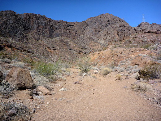
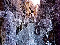
Start of the Canyon
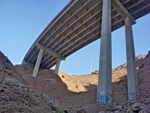
The short approach track leads down the very upper section of the canyon, up to a row of boulders that prevent vehicles driving any further. The hiking route proceeds down the streambed, which is formed of loose gravel and rocks, between low, weathered, reddish cliffs. The drainage stays close to US 93 for a little while, past a set of concrete supports for one of its bridges, then bends away to the south, though the traffic remains remains audible for another ten minutes or so. Helicopter noise is also often encountered, throughout the whole canyon. The streambed contains a few large iron items washed down by occasional floods. Like most of the canyon, this initial section is in shade early in the morning, but receives full sun for most of the day.
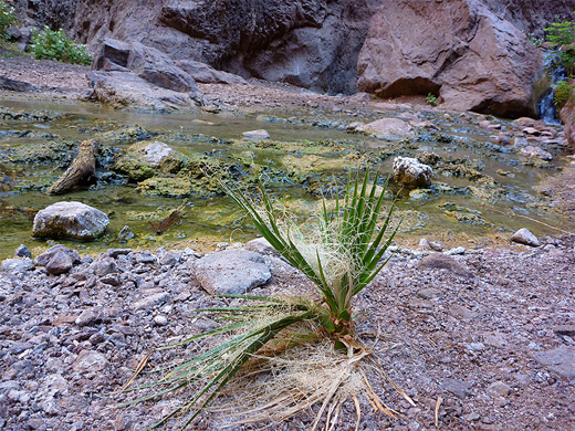
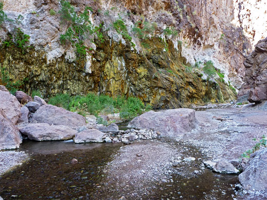
Goldstrike Hot Springs
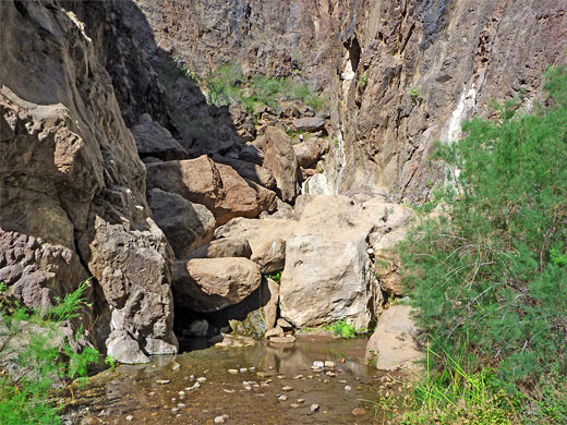
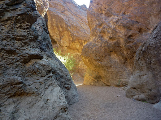
A few bends are followed by a straighter, more open section and the first minor obstacle, a big boulder, passed on the left. Next is a briefly more enclosed passage as the ravine moves through a tight bend, another sunny part where two tributaries join, and then the next obstruction, a larger chokestone passed by steps carved into the cliff face to the right - the first location where a rope is provided, though here it is perhaps not really necessary. Past this are several more chutes and isolated boulders, and a bigger slope covered by jumbled rocks, some very large, and another two places where ropes are installed. Below this slope the ground is moister and seeps start to appear, closely followed by the first group of hot pools (Goldstrike Hot Springs), the main pool located below the north wall of the canyon, its water deepened via a constructed wall. Litter is strewn about, including remains of fire rings. The vegetation in the canyon is generally rather limited; the most abundant plant is probably desert rock nettle, while other species include California suncup, desert rock daisy and southwestern mock vervain. In at least one location a young palm tree has become established.
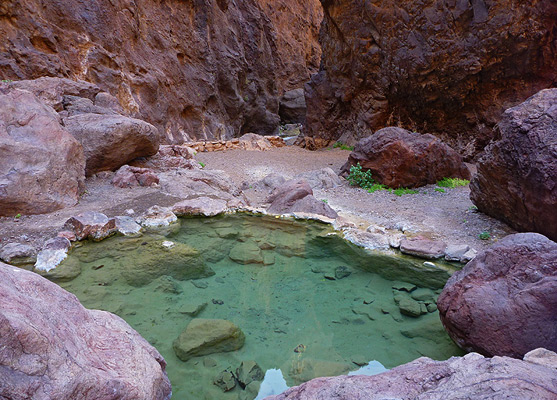
Nevada Hot Springs
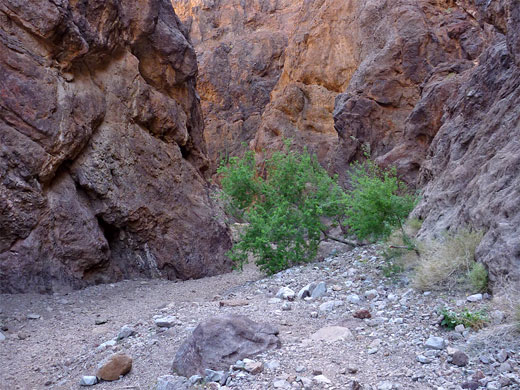
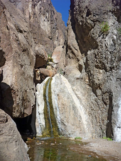
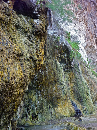
The canyon proceeds with a little waterfall, pool and cascade, the recommended route being down the stone slab on the right side, rope-assisted, but climbing directly down the streamway seems easier. The creek now flows the remainder of the way to the river. Below the fall is a particularly clear-water pool (known as Cave of Wonders), producing nice ripples on the textured rocks just above. Maidenhair ferns and other plants grow in some places along the walls, in moist alcoves. The canyon floor has a larger drop - the most difficult obstacle to overcome if not using a rope - soon after which the ravine flattens out and the stream forms many more pools and small falls, lined by hanging gardens and also in some places by strange, colorful depositional features, partly covered by algae. Above one of these is an elongated sheet waterfall, the waters noticeably warm. This lower group of thermal features is the Nevada Hot Springs, and produces water up to 122 °F.
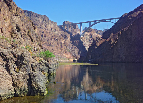
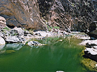
The Colorado River
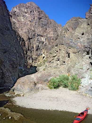
The stream below the final waterfall empties into the Colorado, and the warmth extends a few feet into the river. The confluence is bordered by a small gravel beach and some benches, but the river shoreline is generally inaccessible due to steep cliffs, though low water levels allow walking north or south a short distance. The lower end of Goldstrike Canyon is also frequently visited by rafters and canoeists, launching from the base of the Hoover Dam. A notice warns against drinking any of the water in the canyon, due to the possible presence of naegleria fowleri, a harmful microorganism.
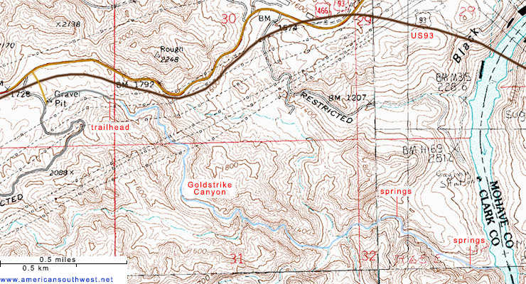
Goldstrike Canyon Topographic Map
Goldstrike Canyon - Similar Hikes
All Contents © Copyright The American Southwest | Comments and Questions | Contribute | Affiliate Marketing Disclosure | Site Map