Dripping Spring Trail, Grand Canyon National Park
Arizona > Grand Canyon National Park > South Rim > Hiking > Dripping Spring Trail
Dripping Spring Trail
Quite popular path descending steeply into upper Hermit Creek, then following a side drainage to a small spring in an alcove beneath a sheer cliff; a good half day hike
Length: 3.1 miles
Elevation change: 1,400 feet
Difficulty: Moderate; first part of trail is steep, and hot in summer
Type: One way; continuation trips possible along the Hermit or Boucher trails
Usage: Light to moderate
Season: Accessible all year; may be snow-covered in winter
Trailhead: Hermits Rest, accessible by private vehicle in winter, free shuttlebus at other times
Rating (1-5): ★★★★★

Dripping Spring is a small but quite reliable source of water, found in an overhanging alcove beneath tall Coconino sandstone cliffs in the upper reaches of a side drainage above Hermit Creek, and the 3.1 mile trail to this cool, shady spot makes a good half day hike, combining a steep descent from Hermits Rest, a traverse above a deep red rock gorge with grand views north towards the Colorado, and an easy walk up the more confined environment of the side ravine. On the return journey, the climb of 1,400 feet back to Hermits Rest can be quite strenuous especially in the late afternoon sun, but the hike as a whole is not too difficult, and it is relatively popular.
The path is the only major Grand Canyon South Rim route that does not descend to the river or meet the Tonto Trail, though it intersects the Hermit & Boucher Trails that do lead to the Colorado, and together (including part of the Tonto) form a loop of 22 miles - a trip just possible in a single, long day though at least one overnight stop is usually required.
Dripping Spring Trail topographic map, South Rim location map.
The path to Dripping Spring - also the first part of the Hermit Trail - begins at the end of a short track from Hermits Rest, at the far end of the West Rim Drive, which is closed for private vehicles most of the year though exceptions are made for overnight hikers with a permit. Day hikers it seems have to use the NPS shuttle (the Red Route), a bumpy vehicle that takes about 40 minutes to drive the 8 miles of road, starting from Grand Canyon Village near the Bright Angel Trailhead. Hermits Rest has a gift shop, cafe, and a supply of free drinking water.
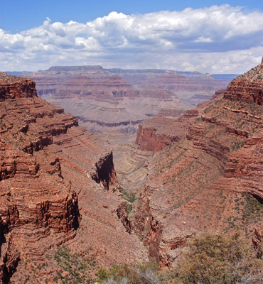
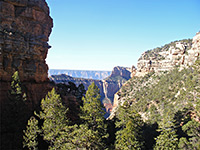
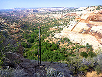
The well maintained path follows a short side ravine then reaches the edge of the deep, wide canyon formed by Hermit Creek, and it offers excellent views from the start - across the canyon to Eremita Mesa and north towards the Colorado River. The route descends a little, traverses southwest a way and drops steeply to the floor of the canyon - down 800 feet over half a mile, to an intersection with the Waldron Trail. This leads southwards across Hermit Basin and up the more gently sloping cliffs at the upper end of the ravine, to the canyon rim where it meets a forest road. The main path continues down a boulder-filled dry wash and soon reaches the Hermit Trail junction; the right fork crosses red rock slopes high above the deep, narrow, sheer-walled canyon of Hermit Creek, eventually descending to the streambed after 5 miles.
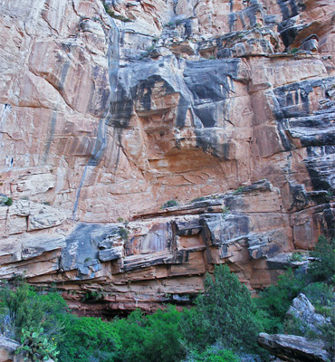
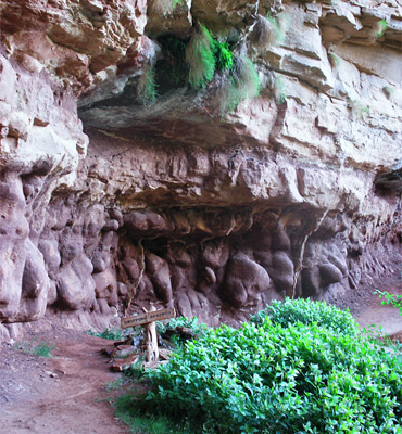
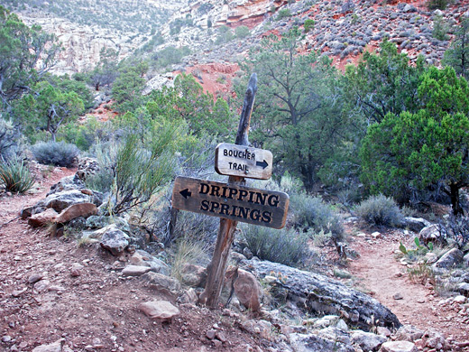
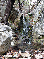
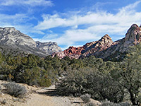
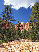
The Dripping Spring Trail leads westwards, now mostly level, around two wide, U-shaped ravines at the head of the Hermit drainage, and provides rather alarming views into the depths. The path is narrow in places and crosses steep, gravelly slopes so some care is needed. On the far side of the canyon is a third junction; right is the Boucher Trail to Travertine Canyon and Boucher Creek, while the left branch reaches Dripping Spring after a gentle ascent over half a mile. At the spring, water drips 15 feet from a group of maidenhair ferns growing at the boundary between the Coconino Sandstone and Hermit Shale strata near the overhanging base of a 200 foot cliff, falling into a small pool and down the bouldery slope below, where the stream quickly sinks below ground, although enough seeps into the soil to nourish quite a large area of trees and plants. The alcove is a quiet, moist place, in shadow most of the day, that in summer provides a welcome relief from the hot surroundings. The water tastes nice though it takes a long time to fill containers as the drips fall over an area of several square feet - best to take a plastic bag and make a funnel.
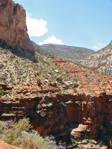
The perennial spring is the usual destination for most people though the path continues, now much fainter but still easy enough to follow. It climbs the north side of the canyon then bends back west, passing above the dryfall and along the overgrown dry streambed beyond, before ending with a short climb to the forested rim, where it meets an old vehicle track that in turn joins the Rowes Well Road. An interesting side trip in this region is the off-trail, cross country walk over Eremita Mesa to Yuma Point.
The path is the only major Grand Canyon South Rim route that does not descend to the river or meet the Tonto Trail, though it intersects the Hermit & Boucher Trails that do lead to the Colorado, and together (including part of the Tonto) form a loop of 22 miles - a trip just possible in a single, long day though at least one overnight stop is usually required.
Maps
Dripping Spring Trail topographic map, South Rim location map.
Dripping Spring Trailhead - Hermits Rest
The path to Dripping Spring - also the first part of the Hermit Trail - begins at the end of a short track from Hermits Rest, at the far end of the West Rim Drive, which is closed for private vehicles most of the year though exceptions are made for overnight hikers with a permit. Day hikers it seems have to use the NPS shuttle (the Red Route), a bumpy vehicle that takes about 40 minutes to drive the 8 miles of road, starting from Grand Canyon Village near the Bright Angel Trailhead. Hermits Rest has a gift shop, cafe, and a supply of free drinking water.
Descent to Hermit Creek
The well maintained path follows a short side ravine then reaches the edge of the deep, wide canyon formed by Hermit Creek, and it offers excellent views from the start - across the canyon to Eremita Mesa and north towards the Colorado River. The route descends a little, traverses southwest a way and drops steeply to the floor of the canyon - down 800 feet over half a mile, to an intersection with the Waldron Trail. This leads southwards across Hermit Basin and up the more gently sloping cliffs at the upper end of the ravine, to the canyon rim where it meets a forest road. The main path continues down a boulder-filled dry wash and soon reaches the Hermit Trail junction; the right fork crosses red rock slopes high above the deep, narrow, sheer-walled canyon of Hermit Creek, eventually descending to the streambed after 5 miles.
The Spring
The Dripping Spring Trail leads westwards, now mostly level, around two wide, U-shaped ravines at the head of the Hermit drainage, and provides rather alarming views into the depths. The path is narrow in places and crosses steep, gravelly slopes so some care is needed. On the far side of the canyon is a third junction; right is the Boucher Trail to Travertine Canyon and Boucher Creek, while the left branch reaches Dripping Spring after a gentle ascent over half a mile. At the spring, water drips 15 feet from a group of maidenhair ferns growing at the boundary between the Coconino Sandstone and Hermit Shale strata near the overhanging base of a 200 foot cliff, falling into a small pool and down the bouldery slope below, where the stream quickly sinks below ground, although enough seeps into the soil to nourish quite a large area of trees and plants. The alcove is a quiet, moist place, in shadow most of the day, that in summer provides a welcome relief from the hot surroundings. The water tastes nice though it takes a long time to fill containers as the drips fall over an area of several square feet - best to take a plastic bag and make a funnel.
Upper End of the Trail
The perennial spring is the usual destination for most people though the path continues, now much fainter but still easy enough to follow. It climbs the north side of the canyon then bends back west, passing above the dryfall and along the overgrown dry streambed beyond, before ending with a short climb to the forested rim, where it meets an old vehicle track that in turn joins the Rowes Well Road. An interesting side trip in this region is the off-trail, cross country walk over Eremita Mesa to Yuma Point.
Dripping Spring Trail - Similar Hikes
All Contents © Copyright The American Southwest | Comments and Questions | Contribute | Affiliate Marketing Disclosure | Site Map