Cedar Mountain Trail, Grand Canyon National Park
Arizona > Grand Canyon National Park > South Rim > Hiking > Cedar Mountain Trail
Cedar Mountain Trail
Little traveled path along an old vehicle track; views of Desert View from the canyon rim, before heading east towards a flat-topped butte
Length: 1.7 miles (to the viewpoint)
Elevation change: 630 feet
Difficulty: Easy; small descent but mostly along the level canyon rim
Type: One way; much longer continuation trips available to Cedar Mountain or Cape Solitude. Short off-trail walk to a better viewpoint
Usage: Light
Season: Accessible all year; may be snow-covered in winter
Trailhead: Desert View, near the employee residence area
Rating (1-5): ★★★★★

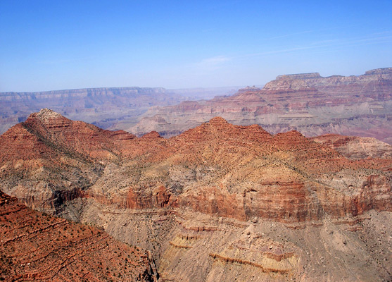
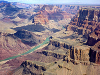
East of Desert View, the East Rim Drive (AZ 64) moves away from the Grand Canyon, since the Colorado River turns sharply northwards, and the intervening land becomes uneven, split by many branched ravines. But hikers can still follow the rim further east, initially via the first part of the Cedar Mountain Trail - a 4WD track that eventually leads to the lower end of the Little Colorado River - and then by the Cape Solitude Trail, which forks off to the north after 2.3 miles and 13 miles later reaches a spectacular canyon overlook directly above the Colorado-Little Colorado junction.
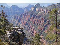
This trip requires at least one night camping en route but the first couple of miles along the Cedar Mountain Trail is a good short hike, giving a rarely-seen perspective of the east side of the Desert View promontory. The views become even better if walking off trail further along the rim - a hike of around one mile over fairly flat, lightly-wooded land passes several promontories that give steadily wider panoramas over the Grand Canyon.
Cedar Mountain Trail topographic map, South Rim location map.
9 views along the Cedar Mountain Trail.
The track to Cedar Mountain is not signposted, and the route is not advertised as a trail. It starts just south of Desert View, initially as a paved road past an employee residence area; visitors may drive a quarter mile past here and park where an unpaved track forks off to the west. This is level and fairly flat for a while then becomes rough, difficult even for some 4WD vehicles, as it drops 600 feet down a slope at the edge of the canyon, whilst curving around the head of a deep ravine due east of Desert View. The route descends over an exposed layer of Kaibab limestone, here partly mineralized, embedded with geodes, quartz veins and multicolored stones.
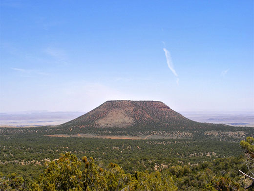
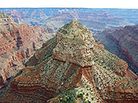
The road switchbacks several times, offering views of the Grand Canyon every second bend; the best is on the outside of the last switchback, after where the road bends east towards Cedar Mountain, a conspicuous, circular, flat-topped peak rising 580 feet above the surrounding level terrain. The mountain is a rare occurrence in this locality of the Moenkopi Formation, a mixture of reddish shale and sandstone that once covered all the Kaibab limestone which now makes up the top layer of the plateau on both sides of the Grand Canyon, but has almost completely eroded away - the only other nearby remnant is Red Butte, a lava-covered summit 12 miles south of Tusayan. The road loops around Cedar Mountain then starts to descend again, crossing more uneven ground towards the Little Colorado River. Another interesting hike would be to climb to the top of the mountain, a further 2 mile walk east from the canyon rim followed by an easy-looking climb up the sloping sides to the mesa top.
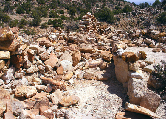
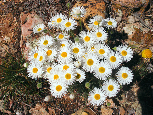
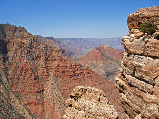
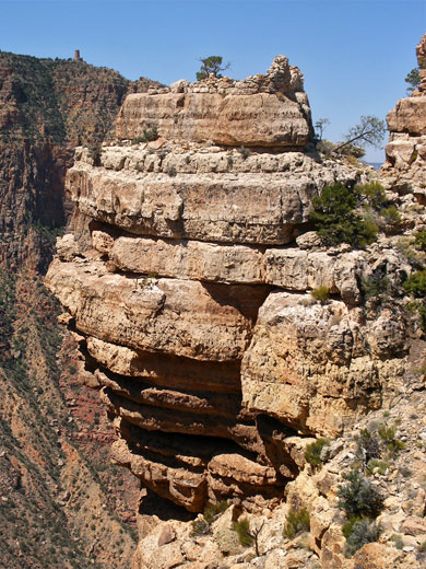
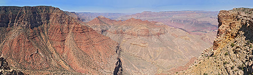
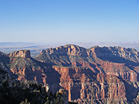
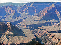
Where the Cedar Mountain road turns eastwards away from the Grand Canyon rim, features in view include the Desert View watchtower, Cardenas Butte, Escalante Butte and the middle of Tanner Canyon, though cliffs to the north hide the most of main gorge. More of the landscape comes into view when walking off-trail along the rim, across several shallow ravines and low ridges, all fairly open - vegetation is a mixture of pinyon and juniper pines, small bushes, cacti (mammillaria, echinocereus, cholla) and plentiful wildflowers. After about a mile, the panorama has expanded to include the Colorado River around Unkar Creek and the lower half of Tanner Canyon, with much of the Tanner Trail visible far below. One of the limestone outcrops at the edge of the rim has what seems to be an old Indian shelter on top, comprising two rooms with walls made of neatly-stacked sandstone blocks, partly ruined but still 3 feet high in places.
This trip requires at least one night camping en route but the first couple of miles along the Cedar Mountain Trail is a good short hike, giving a rarely-seen perspective of the east side of the Desert View promontory. The views become even better if walking off trail further along the rim - a hike of around one mile over fairly flat, lightly-wooded land passes several promontories that give steadily wider panoramas over the Grand Canyon.
Maps
Cedar Mountain Trail topographic map, South Rim location map.
Photographs
9 views along the Cedar Mountain Trail.
The Trail
The track to Cedar Mountain is not signposted, and the route is not advertised as a trail. It starts just south of Desert View, initially as a paved road past an employee residence area; visitors may drive a quarter mile past here and park where an unpaved track forks off to the west. This is level and fairly flat for a while then becomes rough, difficult even for some 4WD vehicles, as it drops 600 feet down a slope at the edge of the canyon, whilst curving around the head of a deep ravine due east of Desert View. The route descends over an exposed layer of Kaibab limestone, here partly mineralized, embedded with geodes, quartz veins and multicolored stones.
Cedar Mountain
The road switchbacks several times, offering views of the Grand Canyon every second bend; the best is on the outside of the last switchback, after where the road bends east towards Cedar Mountain, a conspicuous, circular, flat-topped peak rising 580 feet above the surrounding level terrain. The mountain is a rare occurrence in this locality of the Moenkopi Formation, a mixture of reddish shale and sandstone that once covered all the Kaibab limestone which now makes up the top layer of the plateau on both sides of the Grand Canyon, but has almost completely eroded away - the only other nearby remnant is Red Butte, a lava-covered summit 12 miles south of Tusayan. The road loops around Cedar Mountain then starts to descend again, crossing more uneven ground towards the Little Colorado River. Another interesting hike would be to climb to the top of the mountain, a further 2 mile walk east from the canyon rim followed by an easy-looking climb up the sloping sides to the mesa top.
Along the Canyon Rim
Where the Cedar Mountain road turns eastwards away from the Grand Canyon rim, features in view include the Desert View watchtower, Cardenas Butte, Escalante Butte and the middle of Tanner Canyon, though cliffs to the north hide the most of main gorge. More of the landscape comes into view when walking off-trail along the rim, across several shallow ravines and low ridges, all fairly open - vegetation is a mixture of pinyon and juniper pines, small bushes, cacti (mammillaria, echinocereus, cholla) and plentiful wildflowers. After about a mile, the panorama has expanded to include the Colorado River around Unkar Creek and the lower half of Tanner Canyon, with much of the Tanner Trail visible far below. One of the limestone outcrops at the edge of the rim has what seems to be an old Indian shelter on top, comprising two rooms with walls made of neatly-stacked sandstone blocks, partly ruined but still 3 feet high in places.
Cedar Mountain Trail - Similar Hikes
All Contents © Copyright The American Southwest | Comments and Questions | Contribute | Affiliate Marketing Disclosure | Site Map