Comanche Point Trail, Grand Canyon National Park
Arizona > Grand Canyon National Park > South Rim > Hiking > Comanche Point Trail
Comanche Point Trail
Remote, rarely traveled route, mostly along a disused 4WD track, to a trailless overlook on the east side of the Grand Canyon, in the middle of the Palisades of the Desert. Clear views of nine miles of the Colorado River
Length: 6.2 miles
Elevation change: 670 feet
Difficulty: Moderate; long, but somewhat difficult only towards the end, for the off-trail section
Type: One way
Usage: Low
Season: Accessible all year; may be snow-covered in winter
Trailhead: Desert View, near the employee residence area
Rating (1-5): ★★★★★
Elevation change: 670 feet
Difficulty: Moderate; long, but somewhat difficult only towards the end, for the off-trail section
Type: One way
Usage: Low
Season: Accessible all year; may be snow-covered in winter
Trailhead: Desert View, near the employee residence area
Rating (1-5): ★★★★★

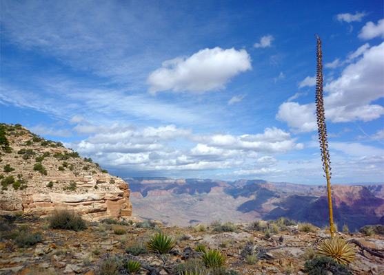
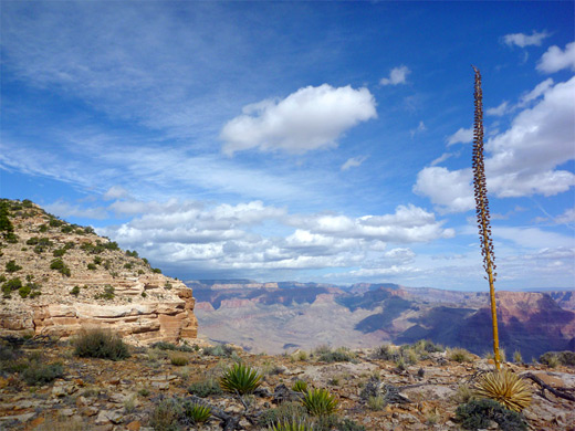
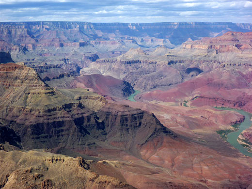
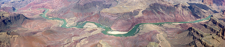
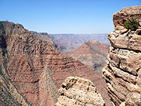
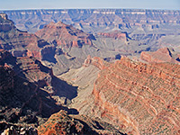
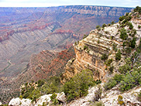
At Desert View, the easternmost overlook along the South Rim Drive, the Colorado River bends northwards and the rim becomes straight and fairly level, with no tributary ravines or major promontories. The land falls away very steeply, vertically down 2,000 feet or more in a great line of red cliffs named Palisades of the Desert, stretching nearly ten miles to the confluence with the Little Colorado River. There are just two named viewpoints along the rim, first being Comanche Point, from where a fantastic panorama extends south, west and north, including nine miles of the Colorado River and much more of the Grand Canyon, from Grandview Point in the south to the cliffs of Desert Facade and the flat plains of the Painted Desert in the north.
Comanche Point may be visited by a long but not difficult hike starting from Desert View, initially via a 4WD track (leading to Cedar Mountain) through wooded terrain, then on a long disused jeep trail that branches off to the north, leaving the forest and crossing open, treeless ground of undulating hills and shallow valleys.
This track ends at Cape Solitude (15 miles from Desert View), and although for most of the way it stays between one and two miles from the canyon edge, Comanche Point is reachable by hiking cross country, into a little valley and steeply up to the viewpoint - since as well as being narrow, and projecting out from the rim, the point is also relatively high, 200 feet above all the surroundings, so the views from the summit are good in all directions.
Comanche Point Trail topographic map, South Rim location map.
20 views along the Comanche Point Trail; plants along the path.
Although the first part of the route to Comanche Point is drivable, along the forest road to Cedar Mountain, a steep and very rocky stretch near the beginning stops all but the most rugged 4WD vehicles, so the usual parking place is at the start of this track, which is just past the Desert View employee residence area, where the approach road turns south to a water treatment facility. It is possible that this location has recently been ruled out of bounds, which case the hike has to begin half a mile away at the large Desert View parking lot.
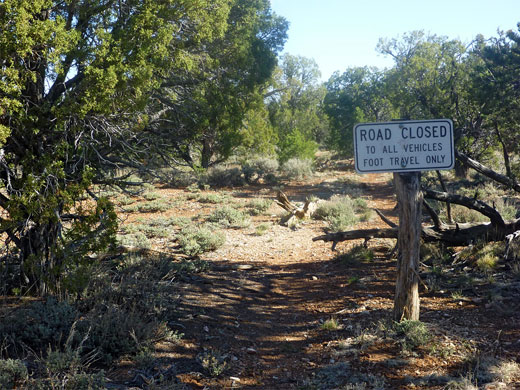
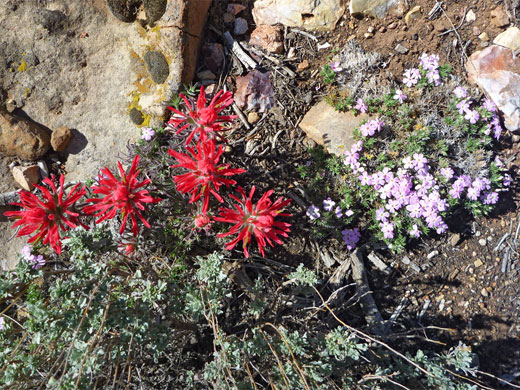
The track stays level a short distance before starting to descend gradually, through medium height woodland of juniper and pinyon pines, mixed with scattered cacti, yucca and wildflowers. The canyon comes into view to the west only occasionally, through gaps in the trees. The track soon drops down much more steeply, via switchbacks, where the surface becomes very rocky in parts, before leveling out and running right along the rim for a little way; a short off-trail hike further along the edge reaches other good viewpoints and a small ruin. After here Cedar Mountain Road turns away from the canyon, back into the woods, and arrives at a junction (2 miles from Desert View) with the disused jeep trail to Cape Solitude, marked by a 'Road Closed' sign - for foot travel only, not even bicycles, and indeed there is no sign of any vehicles having used the track for decades, as some sections are washed away, others are partly blocked by fallen trees, and many good-sized bushes grow in the roadbed.
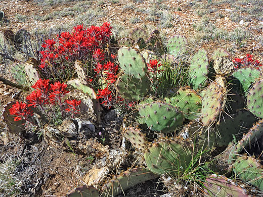
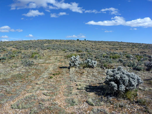
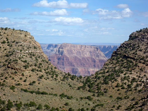
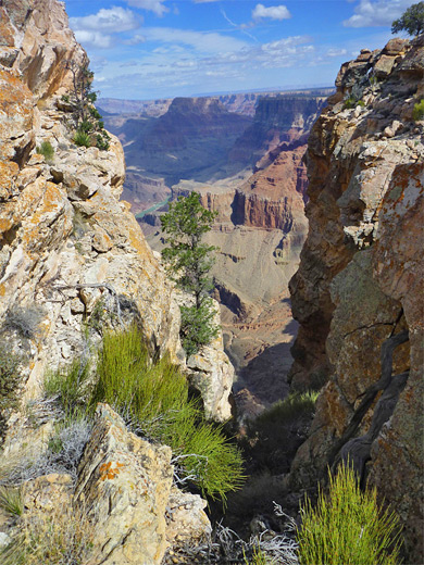
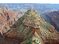
The track enters a little ravine and follows it downstream, either in or beside the dry creekbed, then crosses two small west side tributaries, rises over a ridge and drops down to a slightly deeper valley, the upper end of Straight Canyon, where the path disappears into the rocky streamway. The route is picked up again a short distance east, climbing the hillside to the north, now over open, south-facing limestone slopes, with no trees; the most prominent vegetation are desert plants including Whipple cholla (cylindropuntia whipplei), agave and yucca. The track continues north, across one drainage and up another to a T-junction, surrounded by more flourishing cacti including escobaria vivipara and echinocereus fendleri. The right fork eventually ends at Cape Solitude, while the left is a short spur to a ridgetop; this branch is followed for 0.2 miles to a high point, where the cross-country part of the hike begins, northwards along the ridge then veering west into a partially wooded valley. Comanche Point is now visible to the northwest, its steep slopes forming half of a U-shaped depression along the rim, through which some of the Grand Canyon can be seen, otherwise most is still hidden.
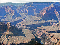
A fairly steep descent of 250 feet reaches a flat, grassy area on the valley floor, near where the streamway turns east, away from the canyon edge. From here the top of Comanche Point is half a mile distant and 700 feet up, above limestone slopes and ledges; steep at first, to a false summit, partly separated from the true apex by a deep ravine eroding from one side, then rising some more to the proper summit, which is quite flat and has a USGS marker right on the edge. At 7,073 feet the point is high enough not just for views of the Grand Canyon but also a long way east, across the Painted Desert and the course of the Little Colorado River. Nine miles of the Colorado River are in full view below, from south of Unkar Creek past Cardenas Creek, Basalt Creek, Tanner Canyon Rapids and Comanche Creek to Lava Canyon Rapids and Carbon Creek. Major buttes and mesas nearby, mostly on the far side of the river include (from south to north) Escalante Butte, Cardenas Butte, Solomon Temple, the Tabernacle, Rana Shrine, Ochoa Point, Apollo Temple, Jupiter Temple, Lava Butte, Temple Butte and Chuar Butte.
Comanche Point may be visited by a long but not difficult hike starting from Desert View, initially via a 4WD track (leading to Cedar Mountain) through wooded terrain, then on a long disused jeep trail that branches off to the north, leaving the forest and crossing open, treeless ground of undulating hills and shallow valleys.
This track ends at Cape Solitude (15 miles from Desert View), and although for most of the way it stays between one and two miles from the canyon edge, Comanche Point is reachable by hiking cross country, into a little valley and steeply up to the viewpoint - since as well as being narrow, and projecting out from the rim, the point is also relatively high, 200 feet above all the surroundings, so the views from the summit are good in all directions.
Maps
Comanche Point Trail topographic map, South Rim location map.
Photographs
20 views along the Comanche Point Trail; plants along the path.
Comanche Point Trailhead
Although the first part of the route to Comanche Point is drivable, along the forest road to Cedar Mountain, a steep and very rocky stretch near the beginning stops all but the most rugged 4WD vehicles, so the usual parking place is at the start of this track, which is just past the Desert View employee residence area, where the approach road turns south to a water treatment facility. It is possible that this location has recently been ruled out of bounds, which case the hike has to begin half a mile away at the large Desert View parking lot.
Cedar Mountain Road
The track stays level a short distance before starting to descend gradually, through medium height woodland of juniper and pinyon pines, mixed with scattered cacti, yucca and wildflowers. The canyon comes into view to the west only occasionally, through gaps in the trees. The track soon drops down much more steeply, via switchbacks, where the surface becomes very rocky in parts, before leveling out and running right along the rim for a little way; a short off-trail hike further along the edge reaches other good viewpoints and a small ruin. After here Cedar Mountain Road turns away from the canyon, back into the woods, and arrives at a junction (2 miles from Desert View) with the disused jeep trail to Cape Solitude, marked by a 'Road Closed' sign - for foot travel only, not even bicycles, and indeed there is no sign of any vehicles having used the track for decades, as some sections are washed away, others are partly blocked by fallen trees, and many good-sized bushes grow in the roadbed.
The Old Jeep Trail
The track enters a little ravine and follows it downstream, either in or beside the dry creekbed, then crosses two small west side tributaries, rises over a ridge and drops down to a slightly deeper valley, the upper end of Straight Canyon, where the path disappears into the rocky streamway. The route is picked up again a short distance east, climbing the hillside to the north, now over open, south-facing limestone slopes, with no trees; the most prominent vegetation are desert plants including Whipple cholla (cylindropuntia whipplei), agave and yucca. The track continues north, across one drainage and up another to a T-junction, surrounded by more flourishing cacti including escobaria vivipara and echinocereus fendleri. The right fork eventually ends at Cape Solitude, while the left is a short spur to a ridgetop; this branch is followed for 0.2 miles to a high point, where the cross-country part of the hike begins, northwards along the ridge then veering west into a partially wooded valley. Comanche Point is now visible to the northwest, its steep slopes forming half of a U-shaped depression along the rim, through which some of the Grand Canyon can be seen, otherwise most is still hidden.
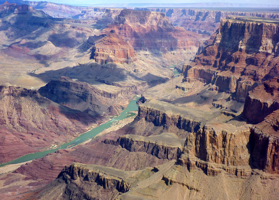
Comanche Point
A fairly steep descent of 250 feet reaches a flat, grassy area on the valley floor, near where the streamway turns east, away from the canyon edge. From here the top of Comanche Point is half a mile distant and 700 feet up, above limestone slopes and ledges; steep at first, to a false summit, partly separated from the true apex by a deep ravine eroding from one side, then rising some more to the proper summit, which is quite flat and has a USGS marker right on the edge. At 7,073 feet the point is high enough not just for views of the Grand Canyon but also a long way east, across the Painted Desert and the course of the Little Colorado River. Nine miles of the Colorado River are in full view below, from south of Unkar Creek past Cardenas Creek, Basalt Creek, Tanner Canyon Rapids and Comanche Creek to Lava Canyon Rapids and Carbon Creek. Major buttes and mesas nearby, mostly on the far side of the river include (from south to north) Escalante Butte, Cardenas Butte, Solomon Temple, the Tabernacle, Rana Shrine, Ochoa Point, Apollo Temple, Jupiter Temple, Lava Butte, Temple Butte and Chuar Butte.
Comanche Point Trail - Similar Hikes
All Contents © Copyright The American Southwest | Comments and Questions | Contribute | Affiliate Marketing Disclosure | Site Map