Highlights:
40 mile scenic drive through the Superstition Mountains northeast of Phoenix, past varied cacti and several deep reservoirs. The majority is unpaved, though still usually accessible by all vehicles, however following a wildfire and rock slide in 2019, the central section is closed 'indefinitely'
Nearby towns:
Management:
County road passing through BLM lands
Location:
Seasons:
May be impassable if wet, and the surroundings are very hot in summer; otherwise, the road is suitable for driving all year
Rating (1-5):
★★★★★
Weather:


The Apache Trail is part of the Indian Lands itinerary
Featured Hotel
Best Western Apache Junction Inn
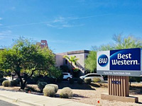 Popular, affordable hotel built in the traditional Southwest adobe style, along the Apache Trail just six miles from the edge of the mountains
Check Rates
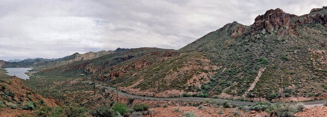
Named after the Apache Indians who once used the route, the Apache Trail, or AZ 88 as it is officially known, links Apache Junction at the edge of the Greater Phoenix area with Theodore Roosevelt Lake, through the Superstition Mountains and the Tonto National Forest; 40 miles of steep, winding and mostly unpaved road past magnificent scenery of twisted igneous mountains with dense forests of saguaro and ferocactus, and several deep blue lakes.
Past the lakes, the original route continues in more traditional fashion to the former copper mining town of Globe (via Hwy 188), but it is the western half which is the most scenic and well-known, however caution is required when driving and it is not recommended for large RVs or caravans; the largest RV rental company in the US (Cruise America) does not allow their vehicles do be taken on this route.
The road though has been mostly closed since late 2019, because of landslips and other damage associated with the Woodbury Fire, worst affected being the steepest section, just west of Fish Creek; the only part still open to vehicular traffic is the (paved) 18 miles from Apache Junction to Tortilla Flat. The seven miles from here to the hill above Fish Creek is accessible though the public are not currently permitted, while the next nine miles, to the turn-off for Apache Lake Marina, is completely closed, 'indefinitely'. The 13 miles from the marina to Roosevelt Dam is open to foot traffic only.
Apache Trail Table of Contents
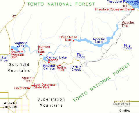
- Map of the Apache Trail
- Photographs
- Lost Dutchman State Park
- Canyon Lake
- Tortilla Flat, Apache Lake and Theodore Roosevelt Dam
- Tours of the Apache Trail
- Globe and Tonto National Monument
- Nearby places
- Similar places
Map of the Apache Trail
Photographs
16 views along the Apache Trail.
Lost Dutchman State Park
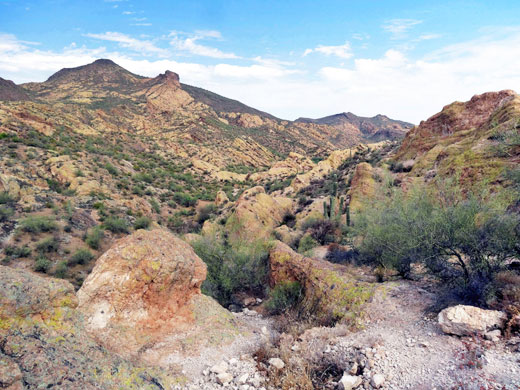
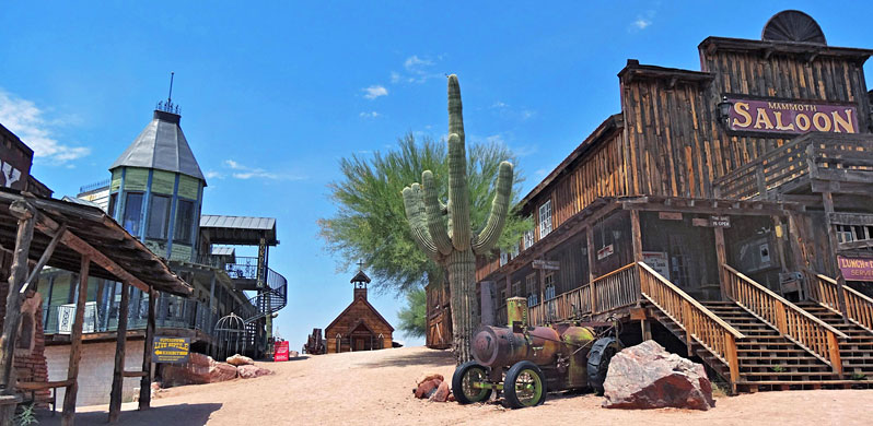
Driving eastwards along Main Street through Mesa, the hazy Superstition Mountains come slowly into view and it is a relief from the seemingly endless suburbia when the AZ 88 turn-off approaches. The first points of interest are Goldfield, supposedly a ghost town but now rather commercialized, and then the Lost Dutchman State Park - this has information about the varied stories and legends associated with the mountains, and in particular about the Lost Dutchman Mine which was supposedly a tremendously rich gold mine worked by a lone prospector but its location was lost upon his death. Nearby is the starting point for several trails leading into the Superstition Wilderness.
Canyon Lake
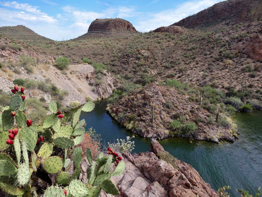
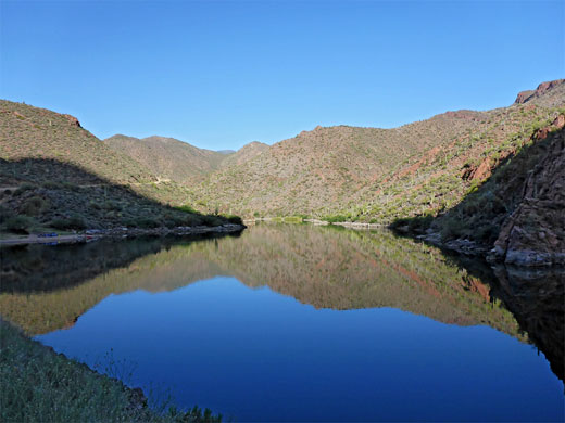
A few miles further, the trail begins to bend sharply as the land becomes steeper, and passes along the shores of Canyon Lake, one of four formed by damming the Salt River, the course of which runs right through Phoenix but is dry for most of the year. Several marinas and one RV campground (which used to be very reasonably priced but is now, 2024, around $50) provide some facilities - the sites tend to have a lot of mosquitoes but do offer free firewood when, and the location is next to a nice clean beach. The land around Canyon Lake is typical of the Tonto National Forest area - crumbling, distorted rock with steep cliffs and twisting ravines, without much covering vegetation but with several species of desert plants. Various lengthy foot-trails traverse the wilderness, leading to remote springs and canyons, such as Fish Creek and La Barge Canyon.
Theodore Roosevelt Dam
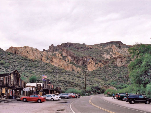
Continuing east, the old-west style settlement of Tortilla Flat (population 6!) is reached - this has various ancient mining and agricultural relics, and an interesting curio shop decorated with mementos from the many visitors who have passed through over the years. Three miles east, the road passes above a short slot canyon with pools and dryfalls, which may be explored in less than an hour. The road fords Tortilla Creek - a crossing that may be closed during high water levels - then soon after, the paved section ends and a narrow gravel track continues for a further 28 miles above the larger Apache Lake, to which access is more limited, and eventually to the Theodore Roosevelt Dam - this was built of bricks in 1911 and remains the world's largest masonry dam at almost 300 feet tall. It is a major element of the Salt River Project which has facilitated the expansion of Phoenix and its environs. The dam seems to be in a state of near-continuous repair or alteration.
Apache Trail Tours
Globe
A few miles south of the dam and along the shores of Theodore Roosevelt Lake, a short side road leads to the preserved cliff dwellings of Tonto National Monument. Further south, there are more marinas along the lakeside before the Apache Trail climbs steadily for 15 miles through more cacti-covered hills and past a few small settlements towards Globe. This is an interesting town, established in 1876 after a large globe-shaped boulder of silver was found nearby. Both copper and silver were later mined extensively, and several old buildings remain from the boom times around the turn of the century. A few miles west, huge copper ore extraction operations still continue around Miami, and US 60 passes several miles of tailings ponds and spoil heaps.
Apache Trail - Nearby Places
- Fish Creek - scenic, watery canyon along the road
- Lost Dutchman State Park - saguaro and other cacti, beneath the Superstition Mountains
- Tonto National Monument - two well-preserved cliff dwellings high above Roosevelt Lake
Apache Trail - Similar Places
- Peach Springs Canyon, Grand Canyon National Park - a gravel road leading to the Colorado River through this canyon passes many fine cacti and colorful cliffs
- Puerto Blanco Drive, Organ Pipe Cactus National Monument - 37 mile track past cactus forests and rugged mountains
All Contents © Copyright The American Southwest | Comments and Questions | Contribute | Affiliate Marketing Disclosure | Site Map