La Barge Canyon and the Boulder Canyon Trail
Arizona > Superstition Mountains > La Barge Canyon and the Boulder Canyon Trail

La Barge Canyon and the Boulder Canyon Trail
Varied route that climbs steadily giving good views of Canyon Lake and the surrounding mountains then descends into a deep drainage (La Barge Canyon), which can be followed south further into the hills, or north through a narrows section back to the trailhead
Length: 2.5 miles (to La Barge Canyon)
Elevation change: 500 feet
Difficulty: Moderate
Type: One way to La Barge Canyon and places further south, or a loop if returning north (off trail) down the canyon
Usage: Light
Season: Winter, spring and fall; summers are hot
Trailhead: Opposite the main parking lot at Canyon Lake Marina
Rating (1-5): ★★★★★

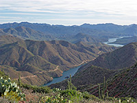
Parking for TR #103, the 7 mile trail past La Barge Creek and along Boulder Canyon, is in the main lot at Canyon Lake Marina, where the section closest to the road is reserved for hikers only, so tends to be empty as most visitors are here for watersports or picnics. The path begins on the south side of AZ 88 beside the one-lane road bridge over the flooded lower end of La Barge Canyon, and immediately starts to climb into the hills, moving away from the water. The route is over open slopes bearing a few bushes, saguaro and other cacti, soon reaching a nice viewpoint over the lake, the canyon and the Apache Trail to the east, winding over the hills towards Tortilla Flat.
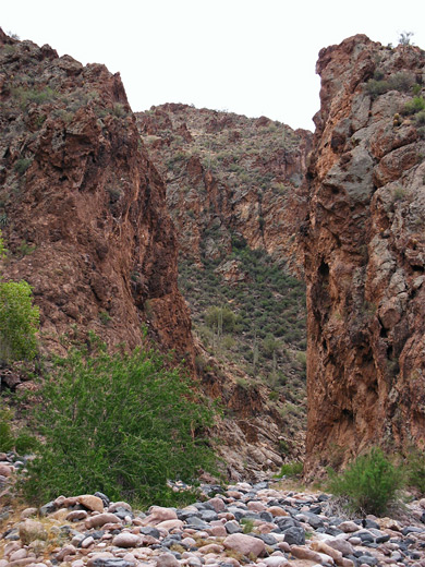
The path curves further away from the canyon for a while, then back to a minor summit at 2,360 feet for better views up the canyon and to the higher peaks beyond, towards the center of the Superstition Mountains. It next rounds the north side of another summit, descends slightly and runs beneath rugged cliffs high above a bend in the canyon where the streamway narrows, through stands of tall saguaro and past several outcrops of colorful, mineralized rocks before dropping down quite steeply to stream level, crossing the drainage not far above a section of narrows around the junction with Boulder Canyon.
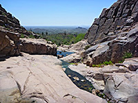
La Barge Canyon is now wide, lacking any vegetation, nearly level and not steep sided, with the edges sloping quite gently up to a high ridge to the east (Geronimo Head) and to a lesser unnamed peak in the west. In the distance, to the south, is Battleship Mountain, with Weaver's Needle further away. The trail continues up the streambed a way, over a saddle and into adjoining Boulder Canyon where it soon splits; right is TR #236 towards the First Water trailhead, while the main route continues up the canyon into the center of the Superstitions. Further upstream along La Barge Canyon, the creek enters a long, deep, quite narrow section with pools and flowing water, and some nice polished rocks. This part is easy enough to explore although there is no official trail.
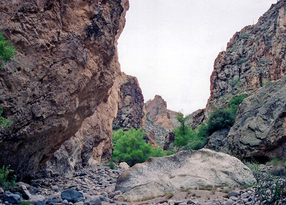
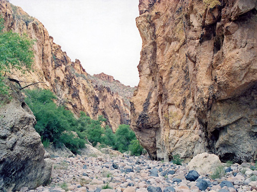
An alternative way back to the Canyon Lake trailhead is to walk down La Barge Canyon, at first over a carpet of pebbles and boulders in a ravine that soon narrows and is overgrown with trees and bushes, as the sides become sheer. There is less undergrowth after the junction with Boulder Canyon, instead more stones and boulders, as the cliffs constrict to the narrowest part of all, where the red, weathered, jagged cliffs are just a few yards apart. Trees and bushes reappear just before several huge boulders that form the one major blockage in the ravine. Below is a deep pool across the whole width of the canyon, that might be impassable after recent heavy rains but most of the time can be passed (on the right side) without getting wet. In midsummer the pool may dry up completely. After some more trees and a thicket of bamboo, the gorge opens out to more boulder piles marking the end of the enclosed section, then it is an easy walk down towards the start of the lake, returning to the official trail by climbing a slope a short distance before the water. The flooded inlet at the lower end of the canyon is too steep sided to walk further at water level.
Views
The path curves further away from the canyon for a while, then back to a minor summit at 2,360 feet for better views up the canyon and to the higher peaks beyond, towards the center of the Superstition Mountains. It next rounds the north side of another summit, descends slightly and runs beneath rugged cliffs high above a bend in the canyon where the streamway narrows, through stands of tall saguaro and past several outcrops of colorful, mineralized rocks before dropping down quite steeply to stream level, crossing the drainage not far above a section of narrows around the junction with Boulder Canyon.
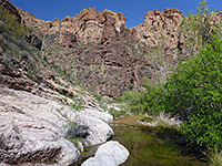
Boulder Canyon
La Barge Canyon is now wide, lacking any vegetation, nearly level and not steep sided, with the edges sloping quite gently up to a high ridge to the east (Geronimo Head) and to a lesser unnamed peak in the west. In the distance, to the south, is Battleship Mountain, with Weaver's Needle further away. The trail continues up the streambed a way, over a saddle and into adjoining Boulder Canyon where it soon splits; right is TR #236 towards the First Water trailhead, while the main route continues up the canyon into the center of the Superstitions. Further upstream along La Barge Canyon, the creek enters a long, deep, quite narrow section with pools and flowing water, and some nice polished rocks. This part is easy enough to explore although there is no official trail.
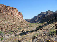
Narrows of La Barge Canyon
An alternative way back to the Canyon Lake trailhead is to walk down La Barge Canyon, at first over a carpet of pebbles and boulders in a ravine that soon narrows and is overgrown with trees and bushes, as the sides become sheer. There is less undergrowth after the junction with Boulder Canyon, instead more stones and boulders, as the cliffs constrict to the narrowest part of all, where the red, weathered, jagged cliffs are just a few yards apart. Trees and bushes reappear just before several huge boulders that form the one major blockage in the ravine. Below is a deep pool across the whole width of the canyon, that might be impassable after recent heavy rains but most of the time can be passed (on the right side) without getting wet. In midsummer the pool may dry up completely. After some more trees and a thicket of bamboo, the gorge opens out to more boulder piles marking the end of the enclosed section, then it is an easy walk down towards the start of the lake, returning to the official trail by climbing a slope a short distance before the water. The flooded inlet at the lower end of the canyon is too steep sided to walk further at water level.
La Barge Canyon - Similar Hikes
All Contents © Copyright The American Southwest | Comments and Questions | Contribute | Affiliate Marketing Disclosure | Site Map