Crater Hills, Yellowstone National Park
Wyoming > Yellowstone National Park > The East > Hiking > Crater Hills
Crater Hills
Off trail hike to a pristine backcountry thermal area, containing especially colorful springs and vents. Route is across grassy hills at the edge of Hayden Valley, frequented by many bison
Length: 1 mile
Elevation change: 200 feet
Difficulty: Easy
Type: One way, cross country; loop around the springs
Usage: Low
Season: Spring, summer, fall
Trailhead: Pullout on the east side of the Grand Loop Road
Rating (1-5): ★★★★★
Elevation change: 200 feet
Difficulty: Easy
Type: One way, cross country; loop around the springs
Usage: Low
Season: Spring, summer, fall
Trailhead: Pullout on the east side of the Grand Loop Road
Rating (1-5): ★★★★★

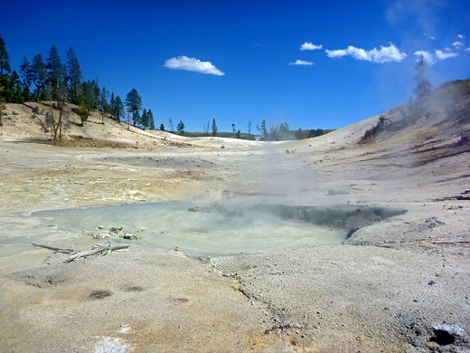
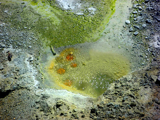
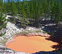
The Crater Hills are a range of low, rounded peaks along the south edge of Hayden Valley near the Yellowstone River, and contain a fascinating collection of sulphurous vents and hot pools (Sulphur Springs), some very energetic, others calmer but unusually colorful, exhibiting a range of rich shades of red, yellow, green and blue, caused by deposited sulphur and iron compounds.
In the early years of Yellowstone National Park visitors could see these little-known thermal features via a wagon trail that crossed the hills just west of the springs, but this was closed many years ago. The area is still close to a road, however, as the main highway alongside the river runs past one mile east and although there are no trails in this area, the pools can be seen by an easy cross-country hike.
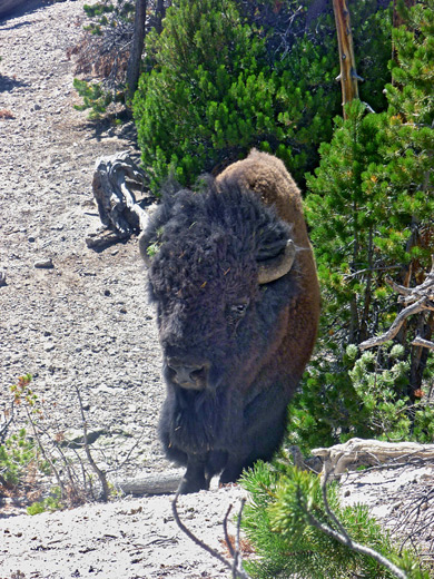
Great care is needed, both to avoid damaging the delicate formations - some of the pools are surrounded by intricate depositional structures - and also because much of the ground is unstable, with thin crusts above boiling, acidic water. Other potential hazards are from the wildlife, as bears are quite common, and bison are abundant; the hills, and Hayden Valley, are one of the prime bison locations in the park, and there may be several hundred animals on the dusty flats around the springs.
All visitors need to be familiar with the park regulations concerning off-trail travel in the vicinity of backcountry thermal regions.
Trail map for Yellowstone National Park.
21 views of the Crater Hills.
Bison and thermal features (mp4; 2:08 min; 40 mb).
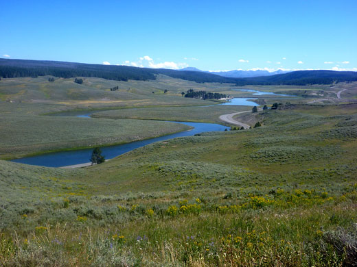
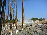
The best place to park for a trip to the Crater Hills is at the southernmost of four pull-outs on the east side of the highway close to the Yellowstone River, just south of Hayden Valley. Owing to the plentiful bison, this area is often very busy, and vehicle jams form when the animals walk across the road. This part of the river valley is bordered on the west side by steep hillsides that hide the springs and the grasslands beyond, but these soon come into view after a short walk up the hills to a ridgetop, over ground crossed by many bison trails. If the bison are in residence then a diversion will be needed, but if not then the springs are reached by hiking due west for a mile, down the far side of the ridge, across a shallow valley and through a thin belt of fire-damaged woodland.
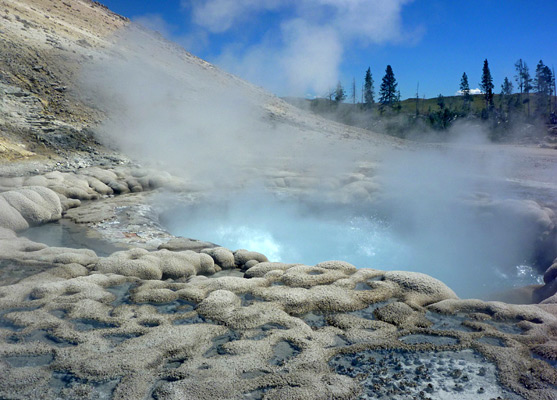
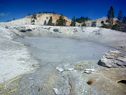
The Sulphur Springs are found on the south side of a prominent rocky summit, which is wooded on top but overlooks a big expanse of white earth nearly half a mile across containing about 70 recognized thermal features, ranging from small vents to a deep boiling pool 25 feet in diameter (Crater Hills Geyser, aka Sulphur Spring). The section closest to the road is at the southeast edge of the basin, and has scattered small vents, variously-sized mud pots and a few large pools filled by bubbling, viscous, brownish-grey water, all surrounded by mud flats. To the southwest, on the far side of a narrow, partly wooded ridge, is a shallow ravine through dry mud hills, with more mud pots, hissing vents and unstable ground, and two named features - Alice Springs and Turbid Blue Mud Spring; the former is a cloudy, boiling spring edged by yellow sulphur deposits, the latter a bubbling, metallic grey pool.
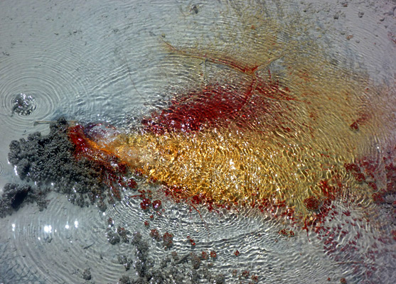
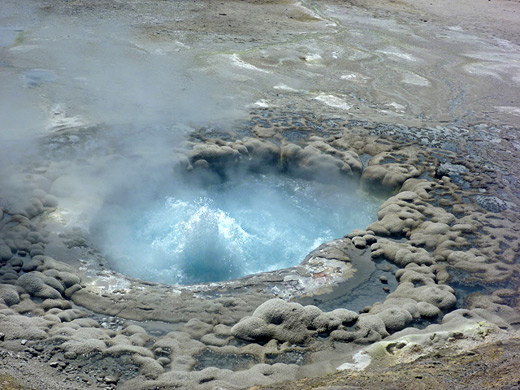
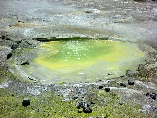
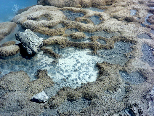
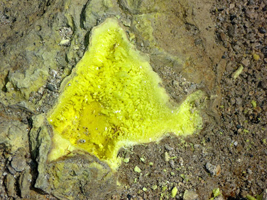
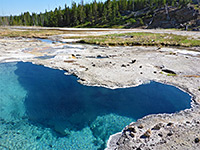
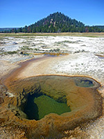
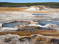
The best group of springs is further north and extends to the edge of the hills, formed by a steep, rocky slope of jagged, whitish rocks in between which are scattered, fierce-sounding gas vents. Below are a variety of hot pools, generally filled with clear or translucent water unlike the cloudy, viscous pools lower down, plus several beautiful springs with unexpectedly bright colors including a lime-green pool, a green pool with red vents, and a tiny opening producing clear water on top of black, red and orange mineral deposits. Some vents are dry but instead emit sulphur-laden gases that condense to form pure yellow crystals. Crater Hills Geyser is the single most impressive feature - a deep, fiercely boiling pool of turquoise-blue water surrounded by extensive depositional sinter formations and shallow pools, like a coral reef at low tide.
In the early years of Yellowstone National Park visitors could see these little-known thermal features via a wagon trail that crossed the hills just west of the springs, but this was closed many years ago. The area is still close to a road, however, as the main highway alongside the river runs past one mile east and although there are no trails in this area, the pools can be seen by an easy cross-country hike.
Great care is needed, both to avoid damaging the delicate formations - some of the pools are surrounded by intricate depositional structures - and also because much of the ground is unstable, with thin crusts above boiling, acidic water. Other potential hazards are from the wildlife, as bears are quite common, and bison are abundant; the hills, and Hayden Valley, are one of the prime bison locations in the park, and there may be several hundred animals on the dusty flats around the springs.
All visitors need to be familiar with the park regulations concerning off-trail travel in the vicinity of backcountry thermal regions.
Location
Trail map for Yellowstone National Park.
Photographs
21 views of the Crater Hills.
Video of the Crater Hills
Bison and thermal features (mp4; 2:08 min; 40 mb).
Approach to the Crater Hills
The best place to park for a trip to the Crater Hills is at the southernmost of four pull-outs on the east side of the highway close to the Yellowstone River, just south of Hayden Valley. Owing to the plentiful bison, this area is often very busy, and vehicle jams form when the animals walk across the road. This part of the river valley is bordered on the west side by steep hillsides that hide the springs and the grasslands beyond, but these soon come into view after a short walk up the hills to a ridgetop, over ground crossed by many bison trails. If the bison are in residence then a diversion will be needed, but if not then the springs are reached by hiking due west for a mile, down the far side of the ridge, across a shallow valley and through a thin belt of fire-damaged woodland.
The Springs
The Sulphur Springs are found on the south side of a prominent rocky summit, which is wooded on top but overlooks a big expanse of white earth nearly half a mile across containing about 70 recognized thermal features, ranging from small vents to a deep boiling pool 25 feet in diameter (Crater Hills Geyser, aka Sulphur Spring). The section closest to the road is at the southeast edge of the basin, and has scattered small vents, variously-sized mud pots and a few large pools filled by bubbling, viscous, brownish-grey water, all surrounded by mud flats. To the southwest, on the far side of a narrow, partly wooded ridge, is a shallow ravine through dry mud hills, with more mud pots, hissing vents and unstable ground, and two named features - Alice Springs and Turbid Blue Mud Spring; the former is a cloudy, boiling spring edged by yellow sulphur deposits, the latter a bubbling, metallic grey pool.
Crater Hills Geyser
The best group of springs is further north and extends to the edge of the hills, formed by a steep, rocky slope of jagged, whitish rocks in between which are scattered, fierce-sounding gas vents. Below are a variety of hot pools, generally filled with clear or translucent water unlike the cloudy, viscous pools lower down, plus several beautiful springs with unexpectedly bright colors including a lime-green pool, a green pool with red vents, and a tiny opening producing clear water on top of black, red and orange mineral deposits. Some vents are dry but instead emit sulphur-laden gases that condense to form pure yellow crystals. Crater Hills Geyser is the single most impressive feature - a deep, fiercely boiling pool of turquoise-blue water surrounded by extensive depositional sinter formations and shallow pools, like a coral reef at low tide.
Crater Hills - Similar Hikes
All Contents © Copyright The American Southwest | Comments and Questions | Contribute | Affiliate Marketing Disclosure | Site Map