Pelican Valley and Turbid Lake, Yellowstone National Park
Wyoming > Yellowstone National Park > The East > Hiking > Pelican Valley and Turbid Lake
Pelican Valley and Turbid Lake
Varied hike through woodland into the lower end of wildlife-filled Pelican Valley, then along a much less-used path to strange, effervescent Turbid Lake, home to many grizzly bears. The whole area is prime grizzly territory, hence various trail restrictions are in place
Length: 5 miles
Elevation change: 120 feet
Difficulty: Easy to moderate
Type: One way. Turbid Lake is also accessible from another trailhead, near Lake Butte, while the main path continues for many miles along the valley
Usage: Medium to Pelican Valley; low to the lake
Season: Summer, fall
Trailhead: End of a short side road, near Indian Pond
Rating (1-5): ★★★★★

Two of the main attractions of Yellowstone National Park, wildlife and thermal springs, may be seen on an interesting half day hike starting along the Grand Loop Road just north of Yellowstone Lake. The Pelican Creek Trail is a lengthy route that leads deep into the backcountry of Pelican Valley, perhaps the prime location in the park for grizzly bears, and also home to bison and other large mammals.
Although the full trip generally requires at least one night at a primitive campsite, the first few miles of the trail give a good introduction to the scenery; as far as a junction, from where a very little used path turns south towards Turbid Lake, a large thermal pool that has a series of mudpots and sulphurous springs along its southeast edge. Most of the forest around the lake was heavily burnt in the 1988 fires, so the shoreline is lined by stark, dead trees, but also by extensive mudflats that reveal evidence of the active grizzly bear population hereabouts, including numerous paw prints and scattered animal carcasses.
The hike to Turbid Lake, walking all around the edge then back to the Pelican Valley trailhead is ten miles and takes about 3 hours; walking is easy apart from a short section of dense, fire damaged forest along the west edge of the lake.
Trail map for Yellowstone National Park.
12 views of Pelican Valley and Turbid Lake.
Springs at Turbid Lake (mp4; 0:50 min; 16 mb).
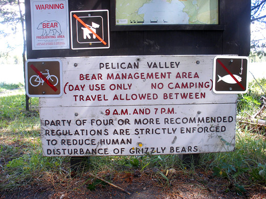
Turbid Lake may be reached from the south, via a 3.5 mile path beginning along the side road to Lake Butte, but the northern route starts from the Pelican Valley trailhead, also at the end of a spur road, one that used to continue directly to the lake, but little trace remains now after the route was reclaimed and restored to nature. Because of the high chance of grizzly bear encounters in Pelican Valley, various restrictions are in place, namely no hiking before 9 am or after 7 pm, no camping, and (a recommendation) people must travel in groups of four or more. However, as the valley is rather wide (a mile or more), flat and treeless, and most of the path runs some distance from the forest that covers the hills at either side, then any bears that are in residence are likely to be spotted quite far in advance.
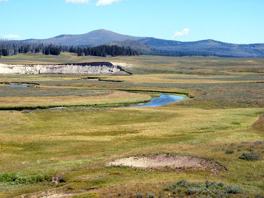
The Pelican Valley parking area is within a group of tall pine trees, but the path leaves the shade and crosses a long grass meadow, over several small streams then into a more extensive stretch of woodland, dark and cool. The land rises slightly, to a fire damaged area where small new growth trees mingle with blackened trunks, surrounded by still-intact forest on all sides; the trail returns to the old trees for a while before emerging into the grasslands at the south edge of Pelican Valley, and is soon heading due east across wide open flats, staying quite far from the creek, which flows slowly around wide meanders to the north. Traces of earlier channels can also be seen, now grassed over. The trail passes through a small group of trees with a minor hot spring to one side, in the middle of a sloping patch of white earth, and shortly after reaches the Turbid Lake junction. The main route continues northeast along the side of the valley, encountering similar scenery for the next 4.5 miles, to another junction beside the Pelican Valley patrol cabin. Various routes branch off, to the Mist Creek, Pelican Cone, Tern Lake and upper Pelican Creek areas, all of which require an overnight stay to explore fully.
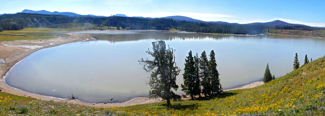
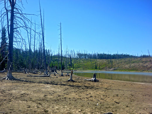
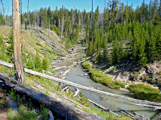
The trail to Turbid Lake is signed from the intersection, but narrow and not often traveled. It heads south up a side valley then peters out after a while, though walking remains easy, over the grasslands, up a gentle slope to a thin belt of trees at the edge of a low cliff, overlooking the lake. A wildflower-covered hillside slopes down steeply to the cloudy, sour-smelling waters, about half a mile across and bordered by mud and marshes to the north, narrower mud flats to the east, and a thin stony beach to the west, parts of which are covered by many fallen, burnt trees, radiating out towards the center. Walking south is easiest above the lake at first, through some thick woodland and down to the lake's exit stream (Sedge Creek), flowing through a deepish ravine. The surrounding forest was completely burnt in 1988, and many downed trees cover the stream and the course of the old trail along this part of the shoreline.
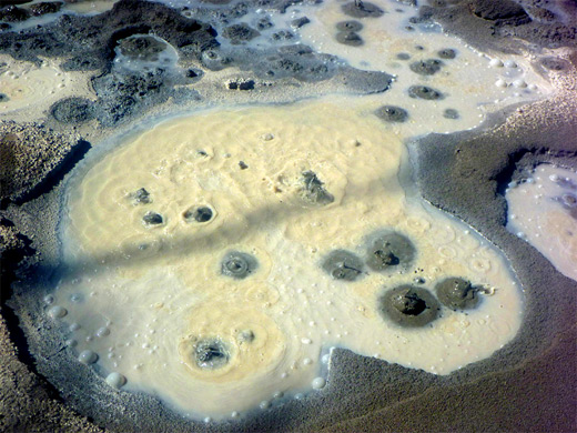
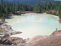
This path becomes more obvious towards the south end of the lake, where it climbs the hillside and reaches the southern Turbid Lake trailhead at Lake Butte after 3.5 miles. Continuing around the shoreline, the next section has many small sulphurous vents (Turbid Springs - see video), emitting steam and acidic water; the whole lake is similarly caustic, and simmers gently in many places. Other springs can be found away from the lake to the southeast, along the inlet stream, the aptly named Bear Creek. The mud around the springs and along the east edge of the lake shows hundreds of bear prints, plus antlers, bones and other animal remains; these, together with the sulphurous smell, the dead trees and the abundant flies, make the place rather strange and unnerving, even if no grizzly bears are actually present. Once across the streams and marshes at the north side of the lake, a short walk up a hillside and across grassy flats links back with the route from Pelican Valley.
Although the full trip generally requires at least one night at a primitive campsite, the first few miles of the trail give a good introduction to the scenery; as far as a junction, from where a very little used path turns south towards Turbid Lake, a large thermal pool that has a series of mudpots and sulphurous springs along its southeast edge. Most of the forest around the lake was heavily burnt in the 1988 fires, so the shoreline is lined by stark, dead trees, but also by extensive mudflats that reveal evidence of the active grizzly bear population hereabouts, including numerous paw prints and scattered animal carcasses.
The hike to Turbid Lake, walking all around the edge then back to the Pelican Valley trailhead is ten miles and takes about 3 hours; walking is easy apart from a short section of dense, fire damaged forest along the west edge of the lake.
Location
Trail map for Yellowstone National Park.
Photographs
12 views of Pelican Valley and Turbid Lake.
Video
Springs at Turbid Lake (mp4; 0:50 min; 16 mb).
Pelican Valley Trailhead
Turbid Lake may be reached from the south, via a 3.5 mile path beginning along the side road to Lake Butte, but the northern route starts from the Pelican Valley trailhead, also at the end of a spur road, one that used to continue directly to the lake, but little trace remains now after the route was reclaimed and restored to nature. Because of the high chance of grizzly bear encounters in Pelican Valley, various restrictions are in place, namely no hiking before 9 am or after 7 pm, no camping, and (a recommendation) people must travel in groups of four or more. However, as the valley is rather wide (a mile or more), flat and treeless, and most of the path runs some distance from the forest that covers the hills at either side, then any bears that are in residence are likely to be spotted quite far in advance.
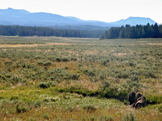
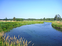
Pelican Valley
The Pelican Valley parking area is within a group of tall pine trees, but the path leaves the shade and crosses a long grass meadow, over several small streams then into a more extensive stretch of woodland, dark and cool. The land rises slightly, to a fire damaged area where small new growth trees mingle with blackened trunks, surrounded by still-intact forest on all sides; the trail returns to the old trees for a while before emerging into the grasslands at the south edge of Pelican Valley, and is soon heading due east across wide open flats, staying quite far from the creek, which flows slowly around wide meanders to the north. Traces of earlier channels can also be seen, now grassed over. The trail passes through a small group of trees with a minor hot spring to one side, in the middle of a sloping patch of white earth, and shortly after reaches the Turbid Lake junction. The main route continues northeast along the side of the valley, encountering similar scenery for the next 4.5 miles, to another junction beside the Pelican Valley patrol cabin. Various routes branch off, to the Mist Creek, Pelican Cone, Tern Lake and upper Pelican Creek areas, all of which require an overnight stay to explore fully.

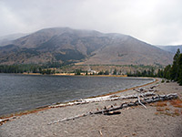
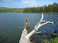
Turbid Lake
The trail to Turbid Lake is signed from the intersection, but narrow and not often traveled. It heads south up a side valley then peters out after a while, though walking remains easy, over the grasslands, up a gentle slope to a thin belt of trees at the edge of a low cliff, overlooking the lake. A wildflower-covered hillside slopes down steeply to the cloudy, sour-smelling waters, about half a mile across and bordered by mud and marshes to the north, narrower mud flats to the east, and a thin stony beach to the west, parts of which are covered by many fallen, burnt trees, radiating out towards the center. Walking south is easiest above the lake at first, through some thick woodland and down to the lake's exit stream (Sedge Creek), flowing through a deepish ravine. The surrounding forest was completely burnt in 1988, and many downed trees cover the stream and the course of the old trail along this part of the shoreline.

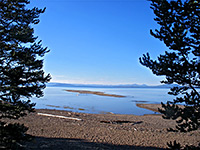
Turbid Springs
This path becomes more obvious towards the south end of the lake, where it climbs the hillside and reaches the southern Turbid Lake trailhead at Lake Butte after 3.5 miles. Continuing around the shoreline, the next section has many small sulphurous vents (Turbid Springs - see video), emitting steam and acidic water; the whole lake is similarly caustic, and simmers gently in many places. Other springs can be found away from the lake to the southeast, along the inlet stream, the aptly named Bear Creek. The mud around the springs and along the east edge of the lake shows hundreds of bear prints, plus antlers, bones and other animal remains; these, together with the sulphurous smell, the dead trees and the abundant flies, make the place rather strange and unnerving, even if no grizzly bears are actually present. Once across the streams and marshes at the north side of the lake, a short walk up a hillside and across grassy flats links back with the route from Pelican Valley.
Pelican Valley and Turbid Lake - Similar Hikes
All Contents © Copyright The American Southwest | Comments and Questions | Contribute | Affiliate Marketing Disclosure | Site Map