Seven Mile Hole Trail, Yellowstone National Park
Wyoming > Yellowstone National Park > The East > Hiking > Seven Mile Hole Trail
Seven Mile Hole Trail
One of the best hikes in all of Yellowstone, this route winds through dense pine forest, past active and inactive thermal areas, then descends steeply to the edge of the Yellowstone River, deep within its Grand Canyon
Length: 5.5 miles
Elevation change: 1,400 feet
Difficulty: Moderate to strenuous
Type: One way. One junction en route, with a path to Mount Washburn
Usage: Medium
Season: Summer, fall
Trailhead: Along the road to Inspiration Point
Rating (1-5): ★★★★★
Elevation change: 1,400 feet
Difficulty: Moderate to strenuous
Type: One way. One junction en route, with a path to Mount Washburn
Usage: Medium
Season: Summer, fall
Trailhead: Along the road to Inspiration Point
Rating (1-5): ★★★★★

The Seven Mile Hole Trail combines all the best elements of Yellowstone National Park into one hike. It starts along the rim of the precipitous Grand Canyon of the Yellowstone River, affording a number of alternative viewpoints to the usual overlooks further west. Next it passes through pine forest and meadows for a while, with a good chance of seeing wildlife, especially grizzly bears who live on the slopes of nearby Mount Washburn. Finally the path descends steeply into the canyon, all the way to the river's edge, passing an active geothermal area containing several hot pools and vents, so although somewhat strenuous, involving a descent and later ascent of 1,400 feet, the 11 mile round trip is hugely rewarding and relatively popular.
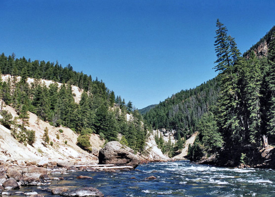
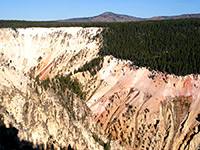
The parking area for the Seven Mile Hole Trail is at the Inspiration Point overlook of the Grand Canyon (north rim), from where it is a short walk back up the access road to the start of the path at Glacial Boulder, a 500 ton rock at the edge of the woods that was left behind by retreating ice about 15,000 years ago. From the rock the well-used trail sets off into the thick lodgepole pine forest, in and out of a shallow ravine then close to the north rim of the Grand Canyon of the Yellowstone for 1.5 miles, offering plenty of opportunities to view the river far below, and the sheer, jagged cliffs on the far side.
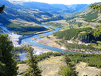
One viewpoint at the end of a short side trail is of 1,000 foot high Silver Cord Cascade, where a narrow chute of water drops to the river from Ribbon Lake on the south rim. The trail bends away from the canyon, climbs a little and forks; left is the Washburn Spur Trail, leading back to the highway, and right is the main route which climbs further to a high point of 8,150 feet then starts to descend. Some parts of the woods are quite dense and it is easy to imagine bears suddenly emerging from the undergrowth, perhaps offering little chance of avoidance.
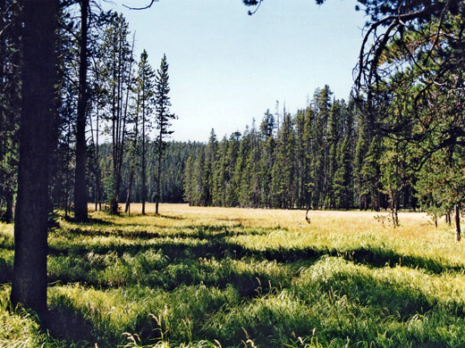
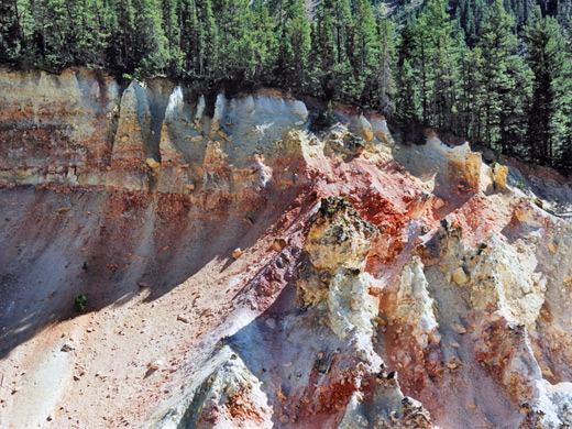
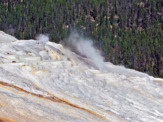
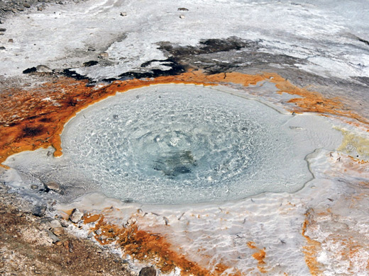
Other parts of the forest are more open, especially a large grassy meadow filled with wildflowers in summer, with views of Mount Washburn to the north, and this too is quite often frequented by grizzly bears. The east side of the meadow is quite marshy, and the path crosses a stream via a small footbridge before dividing again, a point 3 miles from the trailhead. Left is 5.5 more miles to the summit of Mount Washburn while right is the route to Sevenmile Hole. This path becomes level for a while, still following close to the rim but soon starts to descend, steeply at first then less so as it follows a side drainage, past a dormant, white colored geyser cone. Beyond here is more forest as the path becomes steep once more, switchbacking down a rather unstable slope and into a large treeless area with various thermal features and a big expanse of white mineral deposits. There is one especially pretty circular pool, plus various smoking vents, smaller pools and mud pots.
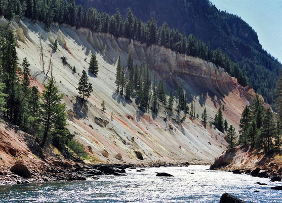
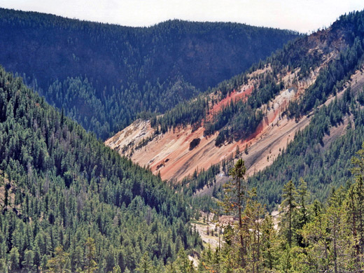
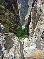
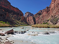
After the thermal zone the path re-enters the forest once more and descends gently towards the river, meeting it close to the junction with a tributary stream (Sulphur Creek). The last mile or so offers nice views of the raging river waters and of volcanic rocks in the cliffs opposite, often brightly colored due to the action of underground steam. Several back country campsites are found along here, though the path runs quite close to them. The Sevenmile Hole itself is a flat area at the end of the trail, so named as it is 7 miles downstream of Lower Yellowstone Falls.
Seven Mile Hole Trailhead
The parking area for the Seven Mile Hole Trail is at the Inspiration Point overlook of the Grand Canyon (north rim), from where it is a short walk back up the access road to the start of the path at Glacial Boulder, a 500 ton rock at the edge of the woods that was left behind by retreating ice about 15,000 years ago. From the rock the well-used trail sets off into the thick lodgepole pine forest, in and out of a shallow ravine then close to the north rim of the Grand Canyon of the Yellowstone for 1.5 miles, offering plenty of opportunities to view the river far below, and the sheer, jagged cliffs on the far side.
The Forest
One viewpoint at the end of a short side trail is of 1,000 foot high Silver Cord Cascade, where a narrow chute of water drops to the river from Ribbon Lake on the south rim. The trail bends away from the canyon, climbs a little and forks; left is the Washburn Spur Trail, leading back to the highway, and right is the main route which climbs further to a high point of 8,150 feet then starts to descend. Some parts of the woods are quite dense and it is easy to imagine bears suddenly emerging from the undergrowth, perhaps offering little chance of avoidance.
The Thermal Area
Other parts of the forest are more open, especially a large grassy meadow filled with wildflowers in summer, with views of Mount Washburn to the north, and this too is quite often frequented by grizzly bears. The east side of the meadow is quite marshy, and the path crosses a stream via a small footbridge before dividing again, a point 3 miles from the trailhead. Left is 5.5 more miles to the summit of Mount Washburn while right is the route to Sevenmile Hole. This path becomes level for a while, still following close to the rim but soon starts to descend, steeply at first then less so as it follows a side drainage, past a dormant, white colored geyser cone. Beyond here is more forest as the path becomes steep once more, switchbacking down a rather unstable slope and into a large treeless area with various thermal features and a big expanse of white mineral deposits. There is one especially pretty circular pool, plus various smoking vents, smaller pools and mud pots.
The Yellowstone River
After the thermal zone the path re-enters the forest once more and descends gently towards the river, meeting it close to the junction with a tributary stream (Sulphur Creek). The last mile or so offers nice views of the raging river waters and of volcanic rocks in the cliffs opposite, often brightly colored due to the action of underground steam. Several back country campsites are found along here, though the path runs quite close to them. The Sevenmile Hole itself is a flat area at the end of the trail, so named as it is 7 miles downstream of Lower Yellowstone Falls.
Seven Mile Hole Trail - Similar Hikes
All Contents © Copyright The American Southwest | Comments and Questions | Contribute | Affiliate Marketing Disclosure | Site Map