Gibbon Hill and Geyser Creek Groups, Yellowstone National Park
Wyoming > Yellowstone National Park > The Northwest > Hiking > Gibbon Hill and Geyser Creek
Gibbon Hill Group and Geyser Creek Group
Off-trail hike to two backcountry thermal areas within Gibbon Geyser Basin, west of Artists Paintpots, containing several active geysers, plus many pools, vents and mudpots. Great care needed in many locations due to unstable ground and thin sinter crusts
Length: 3.6 miles (loop)
Elevation change: 300 feet
Difficulty: Moderate - cross-country navigation, in places across boggy and or overgrown terrain
Type: Loop, off-trail
Usage: Low
Season: Summer, fall
Trailhead: West side of Grand Loop Road, north of Artists Paintpots
Rating (1-5): ★★★★★
Elevation change: 300 feet
Difficulty: Moderate - cross-country navigation, in places across boggy and or overgrown terrain
Type: Loop, off-trail
Usage: Low
Season: Summer, fall
Trailhead: West side of Grand Loop Road, north of Artists Paintpots
Rating (1-5): ★★★★★

The three most accessible sections of Gibbon Geyser Basin are the Chocolate Pots close to the main road, Artists Paint Pots toured by a short trail, and Monument Geyser Basin, at the end of a somewhat longer and steeper path. Other parts may still be reached, however, by cross-country hiking, including the Sylvan Springs to the west, and two regions to the east - the Gibbon Hill Group and the Geyser Creek Group (also known as Geyser Springs).
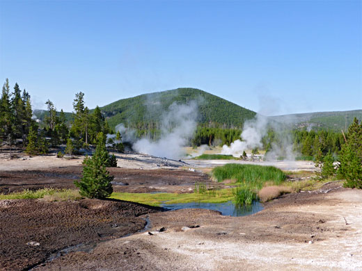
The latter is the largest, and most active, including approximately ten true geysers, and a great assortment of hot pools with widely differing properties, all situated towards the upper end of a narrow valley containing a small stream, Geyser Creek. The other area, close by to the north, is named after what used to be a regular geyser, on wooded slopes beneath the distinctive, circular, volcanic peak of Gibbon Hill, until a 1989 mud slide put a stop to its eruptions. But nearby are plenty more hot pools, also exhibiting a range of colors and activity levels.
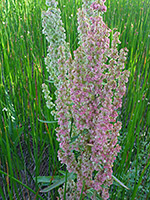
The surrounding land is quite difficult to cross owing to a mix of boggy areas, dense new growth woodland and a lattice of fallen trees; all lies within the area burnt in the great wildfires of 1988. Cross-country navigation is aided by Gibbon Hill, and the smaller but still prominent Paint Pots Hill, both rising well above the surrounding forests, while the thermal areas are also fairly obvious, and the main pools are surrounded by expense extensive open areas, lacking vegetation, although a few have more hidden locations, within the trees.
All the thermal features - approximately 30 large pools and numerous smaller vents and springs - can be seen by an off-trail loop hike of 3.6 miles, starting along the road just north of the turn off to Artists Paint Pots; following the stream that drains the Gibbon Hill region, then crossing a ridge to Geyser Creek and exploring upstream, returning all along the creek, which comes close to the paint pots towards the lower end.
All visitors need to be familiar with the park regulations concerning off-trail travel in the vicinity of backcountry thermal regions.
Trail map for Yellowstone National Park.
36 views of the geyser areas.
Thermal features (mp4; 1:29 min).
A suitable parking place is a lengthy pull out on the west side of the Grand Loop Road, 900 feet north of the turning for Artists Paint Pots, overlooking the flat land of Gibbon Meadows to the west, crossed by the meandering, slow-moving Gibbon River. The route to the Gibbon Hill Group is due east, past a pond, over a little brook and through a marshy area, followed by a patch of drier ground with trees, until another stream soon comes into view, flowing from the geyser basin, its waters noticeably warm. The stream leads to the basin, which is now only half mile away though the terrain is difficult, owing to extensive waterlogged patches and many fallen trees. The creek veers north then back southeast, and eventually passes the edge of the forest - an abrupt change from dense woods to open, white flats.
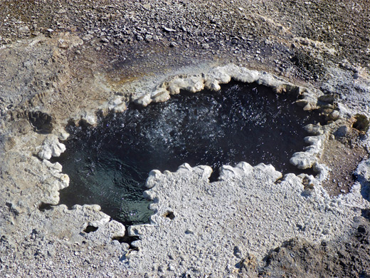
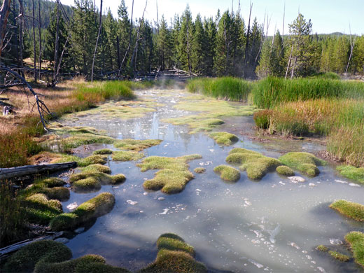
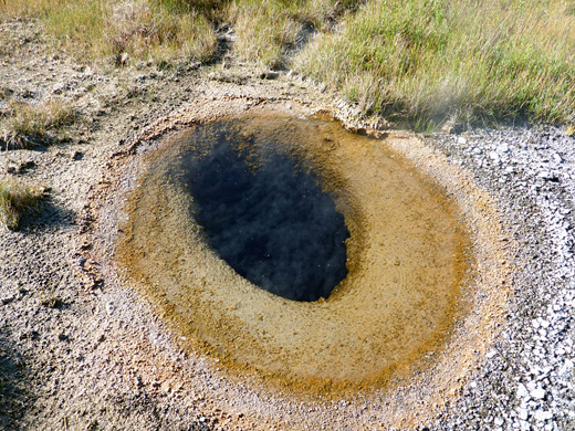
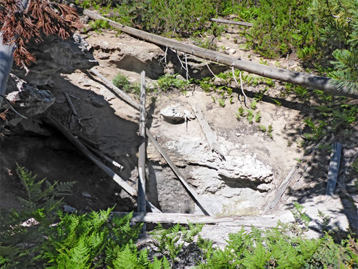
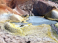
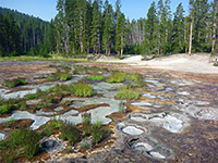
Very few of the features of Gibbon Hill Geyser Basin have an official name. Prominent springs on the north side of the basin include a bubbling pool with a raised rim and a narrow, orange run-off channel, and a big boiling pool partly lined with sinter, beside a stream. The white earth area extends a short distance east, to the far side of a small hill, but mostly south, and the land here contains many minor vents and pools. A patch of trees separates the whitish, main area of the basin from the more overgrown southern section, where the pools are mostly calm and cloudy, warm rather than hot, and exhibit a range of colors, both the water itself and the surrounding algae. A narrow, white streambed extends uphill eastwards a little way, to a sinter-lined gas vent. Further south are a few more pools between wooded patches, leading to a bigger open region that continues to the far side of the main creek. Towards the east of this area is the site of Gibbon Hill Geyser, its crater now barely visible. Past more trees is the biggest pool hereabouts, 240 feet across, filled with greyish, gently bubbling water, and marking approximately the far edge of the basin.
The Geyser Creek Group can be reached by walking southwest, soon crossing the stream, perhaps near a tiny waterfall into a sinter-lined pool, then through closely spaced trees along the east side of a small hill and along the edge of a boggy, grassy corridor that leads, after a thin belt of dry woodland on the far side, to Geyser Creek, at the north edge of its thermal area.
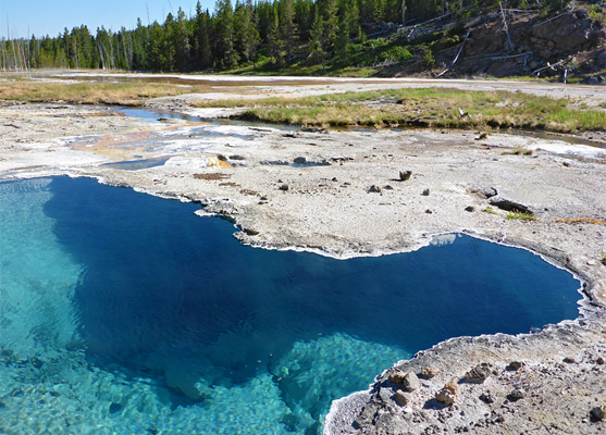
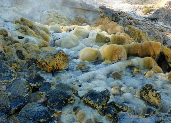
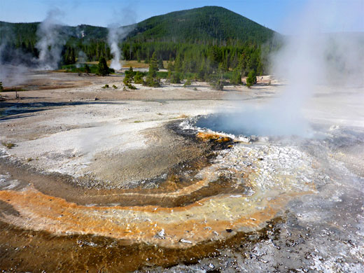
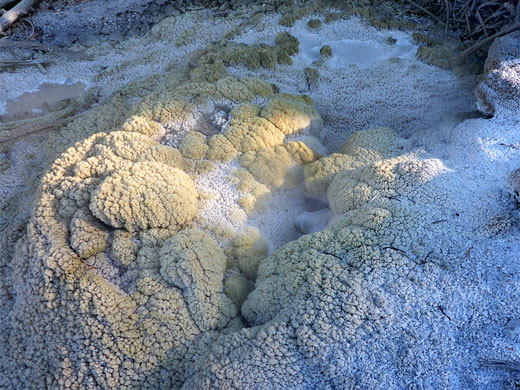
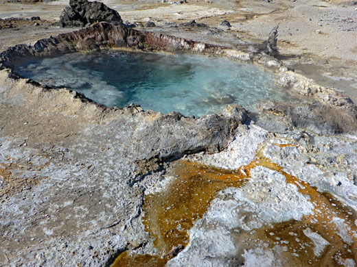
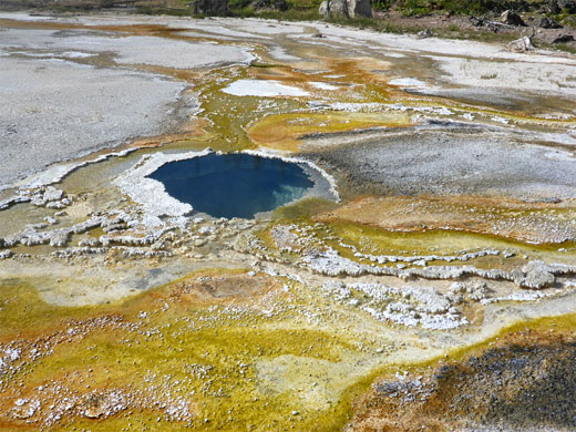
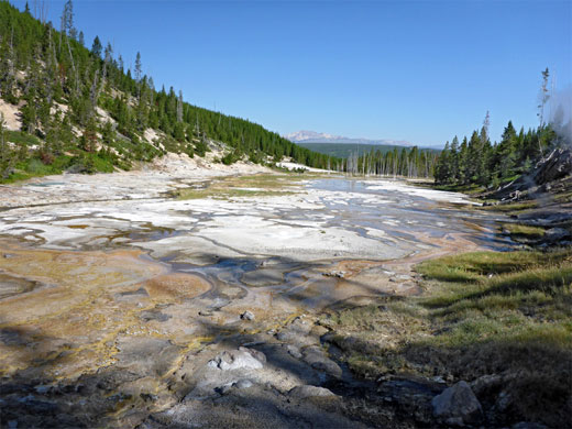
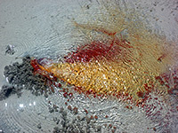
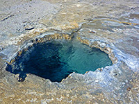
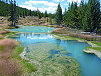
The most immediately conspicuous pool is on the west side of Geyser Creek, containing bright turquoise water, gently bubbling, and for 700 feet south, either side of the stream, the ground is dotted with many other pools and vents, often enclosed by thin sinter crusts, so walking is safest along the edge of the hillside to the west, just above the thermal area. Several springs have names. Bull's Eye Spring contains very clear, boiling water, and is surrounded by a raised grey sinter rim, which has a round hole on one side. Bone Pool is a brilliant blue spring, edged by a particularly thin sinter mat. Close by, on the far side of the creek are Avalanche Geyser (also known as Oblique Geyser) and Big Bowl Geyser, both erupting at regular intervals. The former has multiple (17) small vents, ejecting water at different angles, and all the nearby boulders are covered with richly colored orange-brown geyserite and sulphur. The latter is notable for the delicate, beaded geyserite deposits that encircle its vent.
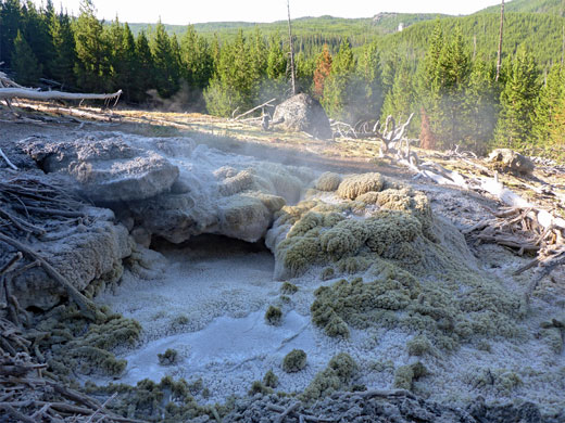
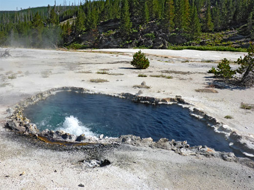
A treeless ridge separates the very active, lower section of the basin with the more overgrown upper part to the south, where the pools are further apart, and the intervening ground is much more stable, and partly grassy. The most active feature is Bat Pool, a deep, boiling, clear water spring, divided into two sections by a sinter bridge. Another, larger, gently fizzing, greyish-blue pool is named Empress Spring, on the east side of the canyon. South of here, the valley is narrower, filled with ferns and trees, and enclosed by steeper sides. Amongst the most distant features are a noisy fumarole, its edges colored grey and yellow, adjacent to a deep, wide vent containing several fallen tree trunks, informally named The Monster.
The route back to the road is mostly all along the stream, back across the geyser basin then into the forest, where again the terrain is not so easy to cross; the drainage splits into several channels, all crossed by many fallen trees, mixed with sometimes dense new growth, but eventually the woods open out to a big, nearly treeless meadow, still boggy and much affected by biting flies in the summer, and the highway can be seen ahead, audible from a long distance away.
The latter is the largest, and most active, including approximately ten true geysers, and a great assortment of hot pools with widely differing properties, all situated towards the upper end of a narrow valley containing a small stream, Geyser Creek. The other area, close by to the north, is named after what used to be a regular geyser, on wooded slopes beneath the distinctive, circular, volcanic peak of Gibbon Hill, until a 1989 mud slide put a stop to its eruptions. But nearby are plenty more hot pools, also exhibiting a range of colors and activity levels.
The surrounding land is quite difficult to cross owing to a mix of boggy areas, dense new growth woodland and a lattice of fallen trees; all lies within the area burnt in the great wildfires of 1988. Cross-country navigation is aided by Gibbon Hill, and the smaller but still prominent Paint Pots Hill, both rising well above the surrounding forests, while the thermal areas are also fairly obvious, and the main pools are surrounded by expense extensive open areas, lacking vegetation, although a few have more hidden locations, within the trees.
All the thermal features - approximately 30 large pools and numerous smaller vents and springs - can be seen by an off-trail loop hike of 3.6 miles, starting along the road just north of the turn off to Artists Paint Pots; following the stream that drains the Gibbon Hill region, then crossing a ridge to Geyser Creek and exploring upstream, returning all along the creek, which comes close to the paint pots towards the lower end.
All visitors need to be familiar with the park regulations concerning off-trail travel in the vicinity of backcountry thermal regions.
Location
Trail map for Yellowstone National Park.
Photographs
36 views of the geyser areas.
Video
Thermal features (mp4; 1:29 min).
Route to Gibbon Hill
A suitable parking place is a lengthy pull out on the west side of the Grand Loop Road, 900 feet north of the turning for Artists Paint Pots, overlooking the flat land of Gibbon Meadows to the west, crossed by the meandering, slow-moving Gibbon River. The route to the Gibbon Hill Group is due east, past a pond, over a little brook and through a marshy area, followed by a patch of drier ground with trees, until another stream soon comes into view, flowing from the geyser basin, its waters noticeably warm. The stream leads to the basin, which is now only half mile away though the terrain is difficult, owing to extensive waterlogged patches and many fallen trees. The creek veers north then back southeast, and eventually passes the edge of the forest - an abrupt change from dense woods to open, white flats.
Gibbon Hill Group
Very few of the features of Gibbon Hill Geyser Basin have an official name. Prominent springs on the north side of the basin include a bubbling pool with a raised rim and a narrow, orange run-off channel, and a big boiling pool partly lined with sinter, beside a stream. The white earth area extends a short distance east, to the far side of a small hill, but mostly south, and the land here contains many minor vents and pools. A patch of trees separates the whitish, main area of the basin from the more overgrown southern section, where the pools are mostly calm and cloudy, warm rather than hot, and exhibit a range of colors, both the water itself and the surrounding algae. A narrow, white streambed extends uphill eastwards a little way, to a sinter-lined gas vent. Further south are a few more pools between wooded patches, leading to a bigger open region that continues to the far side of the main creek. Towards the east of this area is the site of Gibbon Hill Geyser, its crater now barely visible. Past more trees is the biggest pool hereabouts, 240 feet across, filled with greyish, gently bubbling water, and marking approximately the far edge of the basin.
Route to Geyser Creek
The Geyser Creek Group can be reached by walking southwest, soon crossing the stream, perhaps near a tiny waterfall into a sinter-lined pool, then through closely spaced trees along the east side of a small hill and along the edge of a boggy, grassy corridor that leads, after a thin belt of dry woodland on the far side, to Geyser Creek, at the north edge of its thermal area.
Geyser Creek Group - Lower
The most immediately conspicuous pool is on the west side of Geyser Creek, containing bright turquoise water, gently bubbling, and for 700 feet south, either side of the stream, the ground is dotted with many other pools and vents, often enclosed by thin sinter crusts, so walking is safest along the edge of the hillside to the west, just above the thermal area. Several springs have names. Bull's Eye Spring contains very clear, boiling water, and is surrounded by a raised grey sinter rim, which has a round hole on one side. Bone Pool is a brilliant blue spring, edged by a particularly thin sinter mat. Close by, on the far side of the creek are Avalanche Geyser (also known as Oblique Geyser) and Big Bowl Geyser, both erupting at regular intervals. The former has multiple (17) small vents, ejecting water at different angles, and all the nearby boulders are covered with richly colored orange-brown geyserite and sulphur. The latter is notable for the delicate, beaded geyserite deposits that encircle its vent.
Geyser Creek Group - Upper
A treeless ridge separates the very active, lower section of the basin with the more overgrown upper part to the south, where the pools are further apart, and the intervening ground is much more stable, and partly grassy. The most active feature is Bat Pool, a deep, boiling, clear water spring, divided into two sections by a sinter bridge. Another, larger, gently fizzing, greyish-blue pool is named Empress Spring, on the east side of the canyon. South of here, the valley is narrower, filled with ferns and trees, and enclosed by steeper sides. Amongst the most distant features are a noisy fumarole, its edges colored grey and yellow, adjacent to a deep, wide vent containing several fallen tree trunks, informally named The Monster.
Return Route
The route back to the road is mostly all along the stream, back across the geyser basin then into the forest, where again the terrain is not so easy to cross; the drainage splits into several channels, all crossed by many fallen trees, mixed with sometimes dense new growth, but eventually the woods open out to a big, nearly treeless meadow, still boggy and much affected by biting flies in the summer, and the highway can be seen ahead, audible from a long distance away.

Gibbon Hill and Geyser Creek - Similar Hikes
All Contents © Copyright The American Southwest | Comments and Questions | Contribute | Affiliate Marketing Disclosure | Site Map