Death Canyon and Albright Peak, Grand Teton National Park
Wyoming > Grand Teton National Park > Hiking > Death Canyon and Albright Peak
Death Canyon and Albright Peak
Deep, scenic canyon towards the southern end of the Tetons; trail first reaches an overlook of Phelps Lake then traverses meadows and woodland in the canyon. A linked path ascends steeply towards Albright Peak, whose summit can be reached by a short off-trail climb
Length: 3.8 miles to the Alaska Basin junction in the canyon; 7 miles to Albright Peak
Elevation change: 1,040 feet, 3,770 feet
Difficulty: Moderate, strenuous
Type: One way. Linked trails lead to various other destinations
Usage: Medium, low
Season: Lake spring, summer, fall
Trailhead: Death Canyon, at the end of an unpaved road (no RVs)
Rating (1-5): ★★★★★
Elevation change: 1,040 feet, 3,770 feet
Difficulty: Moderate, strenuous
Type: One way. Linked trails lead to various other destinations
Usage: Medium, low
Season: Lake spring, summer, fall
Trailhead: Death Canyon, at the end of an unpaved road (no RVs)
Rating (1-5): ★★★★★

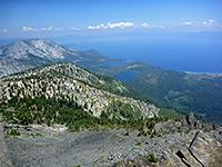
Because of the variety of scenery and the sometimes challenging terrain, the trek to the summit of 10,552 foot Albright Peak is one of the best day hikes in Grand Teton National Park, though with an elevation gain of nearly 4,000 feet and a round trip distance of 14 miles, the trip is not for everyone. The trail leads through pine forest to an overlook of Phelps Lake, enters sheer-walled Death Canyon and continues upstream for several miles then ascends very steeply up the mountainsides towards the peak.
The actual summit is reached by a short off-trail scramble and it affords magnificent views of Jackson Hole and the southern Teton Range. For those not making the full hike, worthwhile destinations are the lake overlook after 0.9 miles and a scenic part of Death Canyon after 3.8 miles, where the ravine opens out to a flat area with tranquil pools, floral meadows, and a good chance of spotting wildlife.
The hike to Albright Peak begins at the Death Canyon trailhead, the principal entry point into the southern Teton Range; this is accessed via a turning off the Moose-Wilson Road, 3 miles from the park headquarters near Moose Junction. The side road is paved at first, as far as a junction after 0.7 miles, from where two unpaved tracks continue, one to the historic White Grass Ranch, the other to the trailhead. This section is narrow, rough and the parking at the end is limited, so RVs and other large vehicles are not recommended.
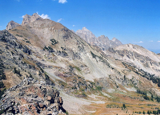
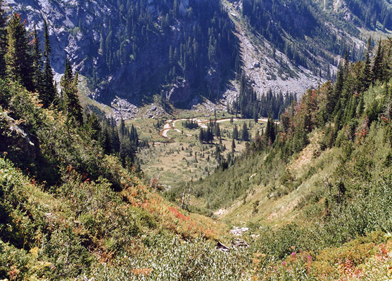
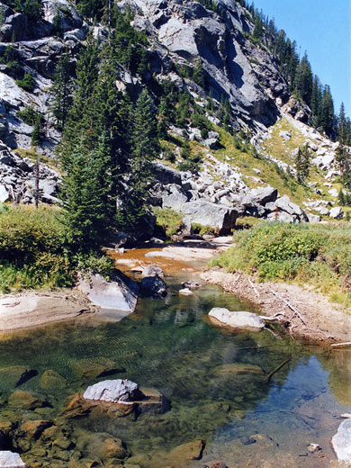
Like the trailhead, the first part of the path is enclosed by thick pine forest, crossed by several small streams. Past a junction with the Valley Trail from Taggart Lake, the path turns left (west) and climbs a bank of glacial moraine through gradually thinning woodland, reaching the overlook of Phelps Lake after 0.9 miles and a 420 foot elevation gain. The lake is large and deep, ringed by forested hills on all sides apart from to the south, where the distant suburbs of Jackson are visible, beyond the Snake River. Near the overlook are two junctions with paths around each edge of the lake, but the main route, although it descends quite sharply, remains a little way above the waters and veers northwards into the lower end of Death Canyon, the principal drainage feeding the lake. The scenery becomes more dramatic, as rugged mountain slopes rise up several thousand feet on both sides, enclosing the clear, fast moving stream that flows year round along the canyon floor. The path stays on the north side passing through patches of trees interspersed by open, rocky areas and scree slopes, climbing steadily for a while before the ground levels out in a wide part of the canyon where three tributary streams join, at the center of a marshy, treeless region - good habitat for moose and other wildlife.
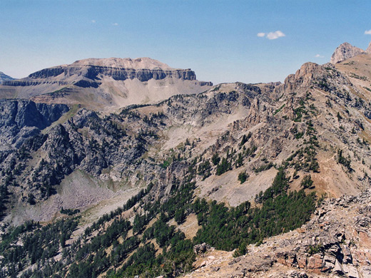
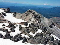
The Death Canyon Trail continues another 5.4 miles westwards, rising to Fox Creek Pass on the national park boundary, but the route to Albright Peak (the Alaska Basin Trail) branches northwards near the stream confluence, and right away starts a very steep, continuous ascent up the mountain slopes. It zig zags up one side of a ravine, crosses the streambed then has three longer switchbacks over forested land before straightening out and heading for the top of a ridge linking Albright Peak with Static Peak, half a mile away and 1,100 feet higher.
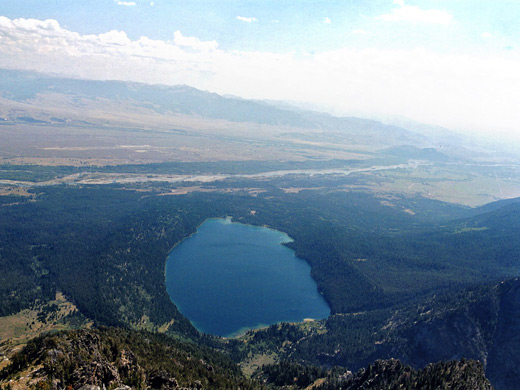
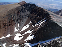
The summit of Albright Peak can be reached by walking southwards along the ridge a little way followed by a short scramble up the weathered boulders lining the summit. The panoramic views extend for many miles over the Teton mountains, the Snake River Valley and the distant Wind River Range beyond. Far beneath (4,000 feet below) lies Phelps Lake, at the foot of smooth grassy slopes mostly free of rocks or trees and it looks tempting to return to the trailhead by walking directly down southeastwards (a hike of only 2 miles rather than 7 by the trail), though the upper slopes are rather steeper than they appear from above.
The actual summit is reached by a short off-trail scramble and it affords magnificent views of Jackson Hole and the southern Teton Range. For those not making the full hike, worthwhile destinations are the lake overlook after 0.9 miles and a scenic part of Death Canyon after 3.8 miles, where the ravine opens out to a flat area with tranquil pools, floral meadows, and a good chance of spotting wildlife.
Death Canyon Trailhead
The hike to Albright Peak begins at the Death Canyon trailhead, the principal entry point into the southern Teton Range; this is accessed via a turning off the Moose-Wilson Road, 3 miles from the park headquarters near Moose Junction. The side road is paved at first, as far as a junction after 0.7 miles, from where two unpaved tracks continue, one to the historic White Grass Ranch, the other to the trailhead. This section is narrow, rough and the parking at the end is limited, so RVs and other large vehicles are not recommended.
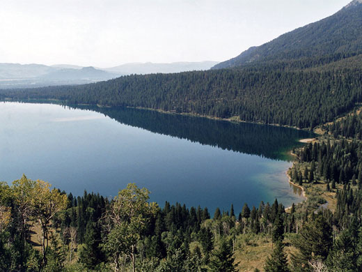
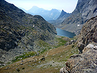
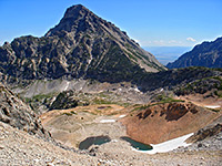
Phelps Lake and Death Canyon
Like the trailhead, the first part of the path is enclosed by thick pine forest, crossed by several small streams. Past a junction with the Valley Trail from Taggart Lake, the path turns left (west) and climbs a bank of glacial moraine through gradually thinning woodland, reaching the overlook of Phelps Lake after 0.9 miles and a 420 foot elevation gain. The lake is large and deep, ringed by forested hills on all sides apart from to the south, where the distant suburbs of Jackson are visible, beyond the Snake River. Near the overlook are two junctions with paths around each edge of the lake, but the main route, although it descends quite sharply, remains a little way above the waters and veers northwards into the lower end of Death Canyon, the principal drainage feeding the lake. The scenery becomes more dramatic, as rugged mountain slopes rise up several thousand feet on both sides, enclosing the clear, fast moving stream that flows year round along the canyon floor. The path stays on the north side passing through patches of trees interspersed by open, rocky areas and scree slopes, climbing steadily for a while before the ground levels out in a wide part of the canyon where three tributary streams join, at the center of a marshy, treeless region - good habitat for moose and other wildlife.
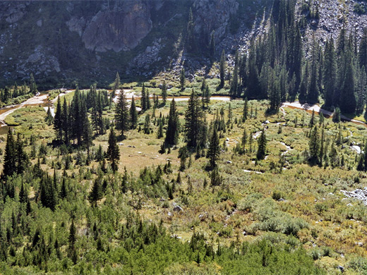
Fox Creek Pass
The Death Canyon Trail continues another 5.4 miles westwards, rising to Fox Creek Pass on the national park boundary, but the route to Albright Peak (the Alaska Basin Trail) branches northwards near the stream confluence, and right away starts a very steep, continuous ascent up the mountain slopes. It zig zags up one side of a ravine, crosses the streambed then has three longer switchbacks over forested land before straightening out and heading for the top of a ridge linking Albright Peak with Static Peak, half a mile away and 1,100 feet higher.
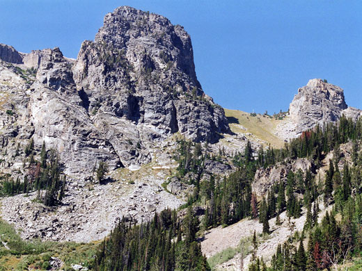
Albright Peak
The summit of Albright Peak can be reached by walking southwards along the ridge a little way followed by a short scramble up the weathered boulders lining the summit. The panoramic views extend for many miles over the Teton mountains, the Snake River Valley and the distant Wind River Range beyond. Far beneath (4,000 feet below) lies Phelps Lake, at the foot of smooth grassy slopes mostly free of rocks or trees and it looks tempting to return to the trailhead by walking directly down southeastwards (a hike of only 2 miles rather than 7 by the trail), though the upper slopes are rather steeper than they appear from above.

Death Canyon and Albright Peak - Similar Hikes
All Contents © Copyright The American Southwest | Comments and Questions | Contribute | Affiliate Marketing Disclosure | Site Map