Cascade Canyon Trail, Grand Teton National Park
Wyoming > Grand Teton National Park > Hiking > Cascade Canyon Trail
Cascade Canyon
Most popular hiking destination in the park; a forested, glacial canyon leading deep into the mountains, eventually reaching Lake Solitude and Paintbrush Divide. At the lower end, two oft-visited locations are Hidden Falls and Inspiration Point
Length: 7.2 miles to Lake Solitude, 9.6 miles to Paintbrush Divide (add 2 miles if not using the shuttle boat)
Elevation change: 2,250 feet, 3,975 feet
Difficulty: Strenuous
Type: One way, or a loop if returning via adjacent Paintbrush Canyon
Usage: High to the lower end of the canyon; low to medium thereafter
Season: Late spring, summer, fall
Trailhead: Jenny Lake, then via boat shuttle to the mouth of the canyon. String Lake is an alternative trailhead
Rating (1-5): ★★★★★

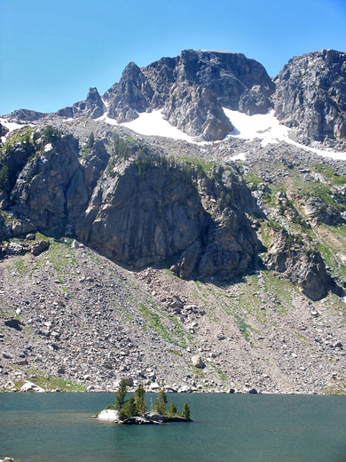
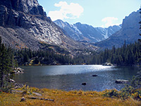
Right at the center of the Teton Range, Cascade Canyon is a textbook example of a U-shaped glacial ravine, surrounded on both sides by the jagged, snow-bound peaks that characterize these mountains, and providing excellent hiking to a variety of destinations, near and far. At the mouth of the canyon, Cascade Creek meets Jenny Lake, at a point reachable either by a 2 mile hike or a boat shuttle, and near here are found the whitewater torrent of Hidden Falls, and a fine overlook of the lake (Inspiration Point).
Further along the path, a short but steep climb leads to a more tranquil section of Cascade Canyon where the creek flows past marshland and through shallow pools, good habitat for moose and other wildlife, and this is the destination for most visitors since the next 3 miles are densely forested, the views restricted and the scenery little changing, but eventually the trees give way to a sparkling Alpine landscape of meadows, white granite boulders, short grass and wildflowers, and, at the far upper end of the ravine (7 miles from Jenny Lake), the beautiful Lake Solitude, sitting in a glacial bowl at 9,035 feet.
The trail continues by climbing another 1,700 feet to Paintbrush Divide from where a 19 mile loop can be made by descending adjacent Paintbrush Canyon then walking south past String Lake towards Jenny Lake.
Location map for Grand Teton National Park
Cascade/Paintbrush Canyon topographic map
16 views along the Cascade Canyon Trail.
There are three ways to reach the lower end of Cascade Canyon: by a boat shuttle, or hikes from north or south, both about 2 miles in distance.
1. Via Boat Shuttle
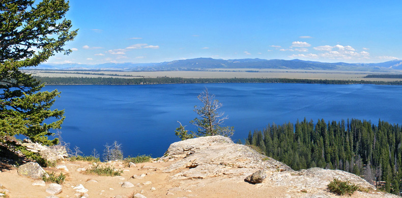
The Jenny Lake boat shuttle takes hikers directly to the Cascade Canyon trailhead, located along the Jenny Lake loop path just north of Cascade Creek. The 1.5 mile journey takes about 10 minutes, is available from mid May to late September, and departs every 15 minutes. Round trip cost (2019) is $15 for adults and $8 for children. Start point is the pier beside the lake's outlet channel, close to the visitor center on the south shore.
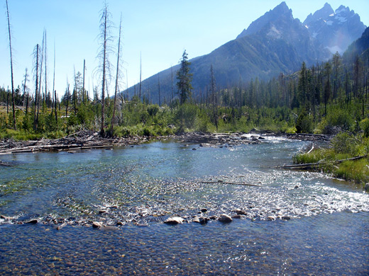
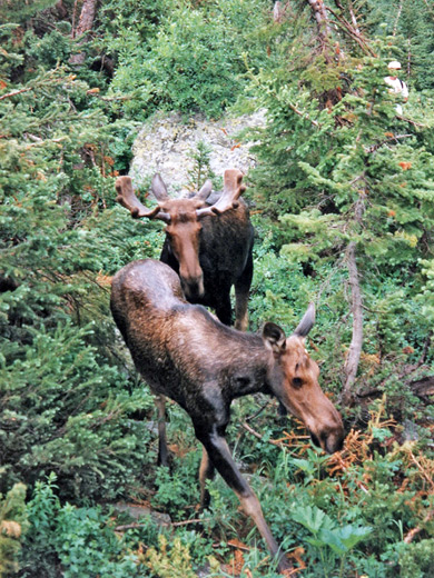
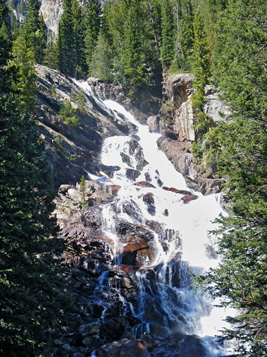
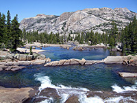
The first location of interest in Cascade Canyon is Hidden Falls, half a mile from the boat arrival dock, and 400 feet above the lake. The falls are an impressive whitewater cascade that is indeed largely hidden from the trail as it continues up a steep, exposed section of cliff face to a treeless promontory (Inspiration Point), which has nice views over Jenny Lake and the Snake River valley towards the Wind River Mountains on the horizon. Beyond here the land becomes fairly level as the path traverses a patch of woodland, then emerges into the wide, lower part of the canyon, where much of the ground is covered by large white granite boulders, broken off the cliffs high above. Cascade Creek runs close by, through shallow pools and calm channels, unlike the steep, fast flowing lower portion. After another half mile the stream splits into different courses and forms larger pools, bordered by quite extensive bushes and other undergrowth; this is one of the most likely places to see moose.
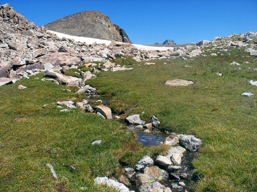
The path continues to climb only gently, as Cascade Canyon becomes predominantly wooded, and stays this way for 2 miles to a junction, at the point where the valley splits into north and south forks. The stream en route has a few more chutes and falls, as tributaries join from both sides (mainly south), fed by melting snow on the mountains above. The Teton Crest Trail follows the south fork of the canyon to Hurricane Pass on the national park boundary, while the main route heads up the north fork, still through woodland for a short distance, until the trees give way to bushes, grassland and wildflowers, mixed with boulder piles and scree slopes. Several more streams flow from hills to the west, enclosed, in summer, by especially varied wildflowers colored red, orange, blue, yellow, pink and purple. Spectacular hillsides curve upwards on both sides, sloping steeply to the summits of Rockchuck Peak and the Teton Crest. The land along this part of the trail, above the treeline, is the only place in Cascade Canyon where primitive camping is permitted; there are plenty of sites to choose from, some above the path, others down near the streamway.
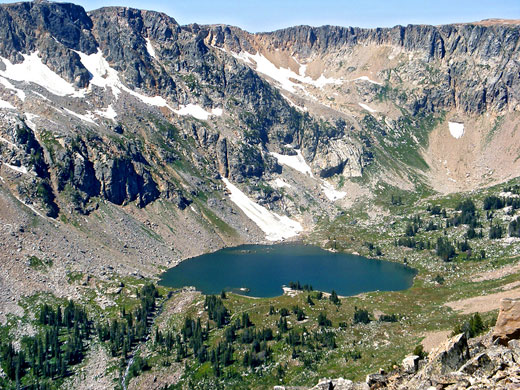
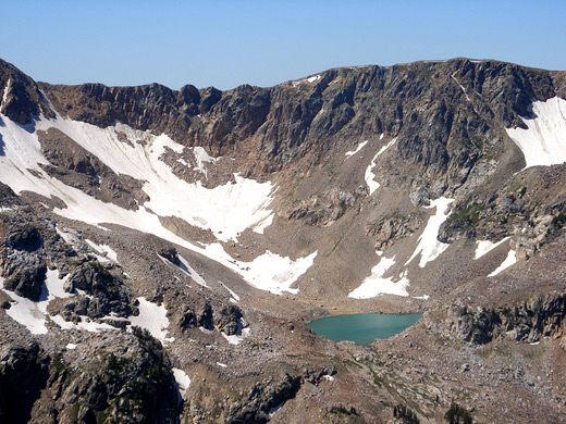
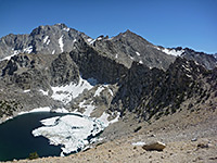
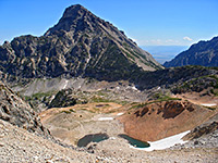
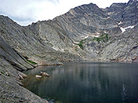
The surroundings are similar for nearly 2 miles, until the path arrives at the edge of Lake Solitude, attractively situated in a glacial bowl at the head of the canyon, enclosed by steep, rocky slopes on three sides. This is the hike destination for most people who walk this far, since the path now climbs by 1,500 feet over the next 2 miles, initially up a grassy hillside and then a scree slope formed of loose, sharp rocks, heading east for most of the ascent but cutting back west near the top, over more boulders towards Paintbrush Divide, separating Cascade Canyon from nearby Paintbrush Canyon. There is no shade on the long climb up the southwest-facing slopes, so conditions can be quite hot on a sunny summer's day. Views are of course spectacular, extending to all the main summits of the Tetons, and (in places) across the crest of the mountains towards the lowlands of Idaho. Also visible near the divide is turquoise-colored Mica Lake, containing meltwater from Petersen Glacier just above.
Further along the path, a short but steep climb leads to a more tranquil section of Cascade Canyon where the creek flows past marshland and through shallow pools, good habitat for moose and other wildlife, and this is the destination for most visitors since the next 3 miles are densely forested, the views restricted and the scenery little changing, but eventually the trees give way to a sparkling Alpine landscape of meadows, white granite boulders, short grass and wildflowers, and, at the far upper end of the ravine (7 miles from Jenny Lake), the beautiful Lake Solitude, sitting in a glacial bowl at 9,035 feet.
The trail continues by climbing another 1,700 feet to Paintbrush Divide from where a 19 mile loop can be made by descending adjacent Paintbrush Canyon then walking south past String Lake towards Jenny Lake.

Maps
Location map for Grand Teton National Park
Cascade/Paintbrush Canyon topographic map
Photographs
16 views along the Cascade Canyon Trail.
Cascade Canyon Trailhead
There are three ways to reach the lower end of Cascade Canyon: by a boat shuttle, or hikes from north or south, both about 2 miles in distance.
1. Via Boat Shuttle
The Jenny Lake boat shuttle takes hikers directly to the Cascade Canyon trailhead, located along the Jenny Lake loop path just north of Cascade Creek. The 1.5 mile journey takes about 10 minutes, is available from mid May to late September, and departs every 15 minutes. Round trip cost (2019) is $15 for adults and $8 for children. Start point is the pier beside the lake's outlet channel, close to the visitor center on the south shore.
2. From the North (String Lake)
The String Lake trailhead is accessed by a side road off the Jenny Lake scenic drive, just north of the start of its one-way section. From the lower of the three parking lots, a trail crosses the stream flowing from String Lake on a wide footbridge, climbs over a small hill and runs alongside the stream, past a few large pools popular for swimming. Trees on the hillside to the west have been killed by a recent wildfire, so vegetation is mostly bushes and grass, mixed with the dead, branchless trunks. The path continues south across steep slopes bordering Jenny Lake, staying a little way above the water and winding in and out of several small ravines. The land becomes forested as the trail rounds a promontory - the trees grow tall and dense, creating a cool, shady environment moistened by a few streams flowing from unseen lakes high above - one of these (Lake of the Crags) is reachable by an unmaintained 2 mile trail that forks off shortly before the main route meets a short path down to the boat landing area, the arrival point for most Cascade Canyon hikers.
The String Lake trailhead is accessed by a side road off the Jenny Lake scenic drive, just north of the start of its one-way section. From the lower of the three parking lots, a trail crosses the stream flowing from String Lake on a wide footbridge, climbs over a small hill and runs alongside the stream, past a few large pools popular for swimming. Trees on the hillside to the west have been killed by a recent wildfire, so vegetation is mostly bushes and grass, mixed with the dead, branchless trunks. The path continues south across steep slopes bordering Jenny Lake, staying a little way above the water and winding in and out of several small ravines. The land becomes forested as the trail rounds a promontory - the trees grow tall and dense, creating a cool, shady environment moistened by a few streams flowing from unseen lakes high above - one of these (Lake of the Crags) is reachable by an unmaintained 2 mile trail that forks off shortly before the main route meets a short path down to the boat landing area, the arrival point for most Cascade Canyon hikers.
3. From the South (Jenny Lake)
The southern part of the Jenny Lake loop trail can be joined either at the boat shuttle parking lot, a side track off the Lupine Meadows Road, or a pull-out a little further along this road, from where a connecting path links with the main route. There are two parallel trails leading northwest to Cascade Canyon, one close to the shoreline, the other (intended for horses) 300 feet higher up the partly forested slopes. This leads directly to Hidden Falls, while the lower branch passes the boat landing pier, and joins with two paths up into the canyon.
The southern part of the Jenny Lake loop trail can be joined either at the boat shuttle parking lot, a side track off the Lupine Meadows Road, or a pull-out a little further along this road, from where a connecting path links with the main route. There are two parallel trails leading northwest to Cascade Canyon, one close to the shoreline, the other (intended for horses) 300 feet higher up the partly forested slopes. This leads directly to Hidden Falls, while the lower branch passes the boat landing pier, and joins with two paths up into the canyon.
Hidden Falls and Inspiration Point
The first location of interest in Cascade Canyon is Hidden Falls, half a mile from the boat arrival dock, and 400 feet above the lake. The falls are an impressive whitewater cascade that is indeed largely hidden from the trail as it continues up a steep, exposed section of cliff face to a treeless promontory (Inspiration Point), which has nice views over Jenny Lake and the Snake River valley towards the Wind River Mountains on the horizon. Beyond here the land becomes fairly level as the path traverses a patch of woodland, then emerges into the wide, lower part of the canyon, where much of the ground is covered by large white granite boulders, broken off the cliffs high above. Cascade Creek runs close by, through shallow pools and calm channels, unlike the steep, fast flowing lower portion. After another half mile the stream splits into different courses and forms larger pools, bordered by quite extensive bushes and other undergrowth; this is one of the most likely places to see moose.
Cascade Canyon
The path continues to climb only gently, as Cascade Canyon becomes predominantly wooded, and stays this way for 2 miles to a junction, at the point where the valley splits into north and south forks. The stream en route has a few more chutes and falls, as tributaries join from both sides (mainly south), fed by melting snow on the mountains above. The Teton Crest Trail follows the south fork of the canyon to Hurricane Pass on the national park boundary, while the main route heads up the north fork, still through woodland for a short distance, until the trees give way to bushes, grassland and wildflowers, mixed with boulder piles and scree slopes. Several more streams flow from hills to the west, enclosed, in summer, by especially varied wildflowers colored red, orange, blue, yellow, pink and purple. Spectacular hillsides curve upwards on both sides, sloping steeply to the summits of Rockchuck Peak and the Teton Crest. The land along this part of the trail, above the treeline, is the only place in Cascade Canyon where primitive camping is permitted; there are plenty of sites to choose from, some above the path, others down near the streamway.
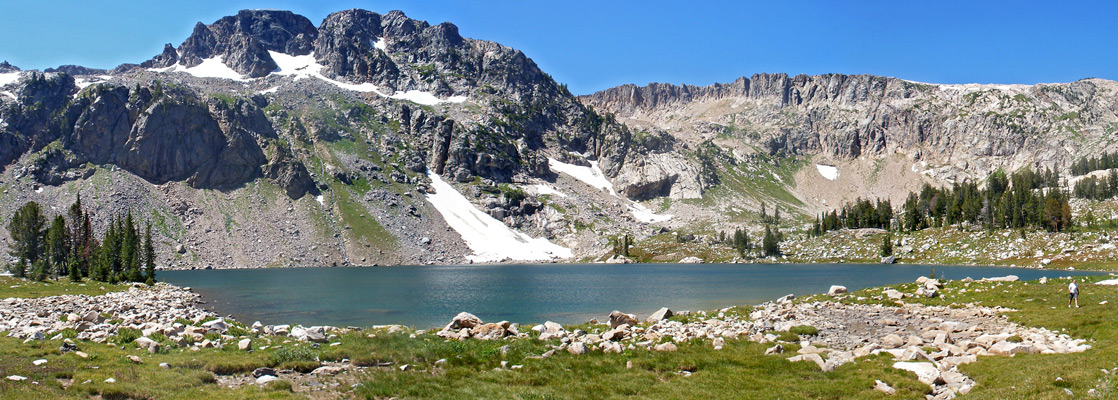
Lake Solitude and Paintbrush Divide
The surroundings are similar for nearly 2 miles, until the path arrives at the edge of Lake Solitude, attractively situated in a glacial bowl at the head of the canyon, enclosed by steep, rocky slopes on three sides. This is the hike destination for most people who walk this far, since the path now climbs by 1,500 feet over the next 2 miles, initially up a grassy hillside and then a scree slope formed of loose, sharp rocks, heading east for most of the ascent but cutting back west near the top, over more boulders towards Paintbrush Divide, separating Cascade Canyon from nearby Paintbrush Canyon. There is no shade on the long climb up the southwest-facing slopes, so conditions can be quite hot on a sunny summer's day. Views are of course spectacular, extending to all the main summits of the Tetons, and (in places) across the crest of the mountains towards the lowlands of Idaho. Also visible near the divide is turquoise-colored Mica Lake, containing meltwater from Petersen Glacier just above.
Cascade Canyon - Similar Hikes
All Contents © Copyright The American Southwest | Comments and Questions | Contribute | Affiliate Marketing Disclosure | Site Map