Leigh Lake and Moran Bay, Grand Teton National Park
Wyoming > Grand Teton National Park > Hiking > Leigh Lake and Moran Bay
Leigh Lake and Moran Bay
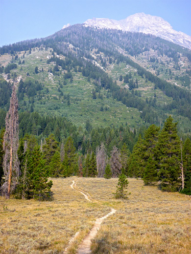
A mostly level trail that starts at String Lake, runs all along the forested east shore of Leigh Lake then reaches two much smaller lakes (Bearpaw and Trapper). A continuation path descends a little to Bearpaw Bay on Jackson Lake, where the shoreline can be followed northwest towards Moran Bay, past several islands and a scenic lagoon filed with dead tree stumps. All the route has good views of the nearby mountains
Length: 4.3 miles to Trapper Lake, 6.5 miles to the lagoon and a view of Moran Bay
Elevation change: 70 feet, 140 feet
Difficulty: Moderate
Type: One way
Usage: High to the southern half of Leigh Lake; low thereafter
Season: Late spring, summer, fall
Trailhead: Beside String Lake
Rating (1-5): ★★★★★
Elevation change: 70 feet, 140 feet
Difficulty: Moderate
Type: One way
Usage: High to the southern half of Leigh Lake; low thereafter
Season: Late spring, summer, fall
Trailhead: Beside String Lake
Rating (1-5): ★★★★★

Lakes, forest, wildflowers, wildlife and views of the northern Tetons are the attractions of the 4.3 mile Leigh Lake Trail, a well used route that starts near String Lake, parallels the wooded east shore of the much larger Leigh Lake and ends by visiting two, more hidden lakes (Bearpaw and Trapper). An unofficial but good quality continuation path follows a stream northwards through more forest to Bearpaw Bay on Jackson Lake, where the shoreline can be followed northwest another mile or two towards Moran Bay, scenically situated beneath two rarely explored canyons and three high summits.
Along the way are white sand beaches, several small islands and an unusual lagoon, lined by marshes and dotted with hundreds of dead tree stumps, more reminiscent of a Louisiana swamp than the Wyoming mountains. The distance to this photogenic point is 6.5 miles, over mostly level ground, and the trip could be extended even more by continuing along the Jackson Lake shoreline to Moran Canyon, and maybe heading upstream. The area around String Lake and the southernmost section of Leigh Lake is usually rather busy but the remainder is much more peaceful, and very few people progress beyond Trapper Lake.
Location map for Grand Teton National Park. Leigh Lake/Moran Bay topographic map.
30 views along the Leigh Lake Trail and Jackson Lake.
Flower pictures along the trail; near Leigh Lake, near Jackson Lake.
Scenes along the shoreline of Jackson Lake (mp4; 0:57 min; 25 mb).
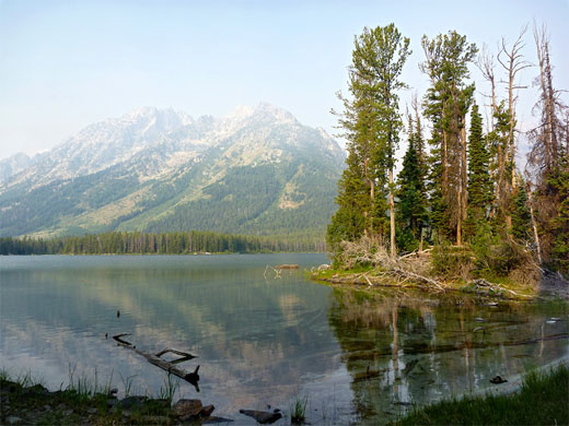
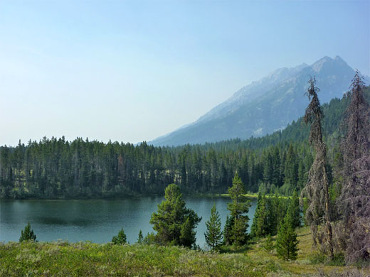
The popular String Lake trailhead is reached by a short side road off the Jenny Lake Loop, at the start of its one-way section. The parking lot is nearly empty first thing in the morning but may be full with hundreds of cars on a sunny summer's afternoon. The adjacent String Lake is pretty though certainly not a place for solitude, as the vast majority of visitors stay in the vicinity; swimming, resting on the beaches, walking the 3.3 mile trail that circles the shoreline or padding canoes on the water. From the trailhead, the path leads quickly along the eastern shore to a junction, the left fork being the continuation of the loop and also the way to the backcountry route up Paintbrush Canyon. Another intersection soon after is with a spur used for launching boats on Leigh Lake just to the north. After climbing up and down a narrow range, the right fork of the path proceeds all along the eastern edge of Leigh Lake through shady, rather dry forest where wildflowers are limited, generally staying between 50 and 200 feet from the water, though within easy reach of many tiny beaches and rocky shore access points, plus a few promontories and islands.
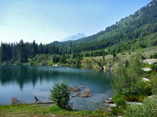
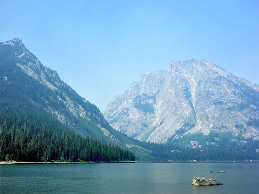
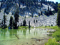
There are several primitive campsites about halfway along Leigh Lake, right by the water, some adjoining narrow sandy beaches and most with views across to Leigh Canyon and the very steep south face of Mount Moran. They have a reputation for being quite frequently visited by bears. The forest becomes thinner, and partly burnt by recent fires towards the north end of the lake, the ground more boulder-covered, and wildflowers more abundant. The trail climbs above the shore and moves away from the lake, curving west through more sparse woodland to an open grassy area, and another intersection, signed Bearpaw Lake right, Trapper Lake straight on; this branch re-enters the forest briefly and soon crosses a small inlet stream of Bearpaw Lake, followed by a slightly larger tributary, near two primitive campsites. The lake is completely wooded and not particularly scenic, at least not when viewed from the western shore where the path leads.
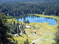
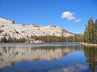
From Bearpaw Lake the trail climbs a little over a treeless hillside (better views of the lake from here), crosses a thin belt of woodland and emerges to a meadow at the north end of the prettier Trapper Lake, which has a good sized inlet stream at the north end, originating high above from Skillet Glacier just below the summit of Mount Moran. Beavers have constructed a two-level pond beside the lake. The path ends here, but a loop (with the path signed Bearpaw Lake) can be made by following a fainter, hiker-made route forking off about half way back to this lake, over grassy slopes above the exit drainage and down to the north end of a patch of marshy grassland, crossing the stream via fallen logs, to the north end of the other path, from where the junction near Leigh Lake is half a mile south - along the edge of the grassland beside the stream, then through a short strip of forest.
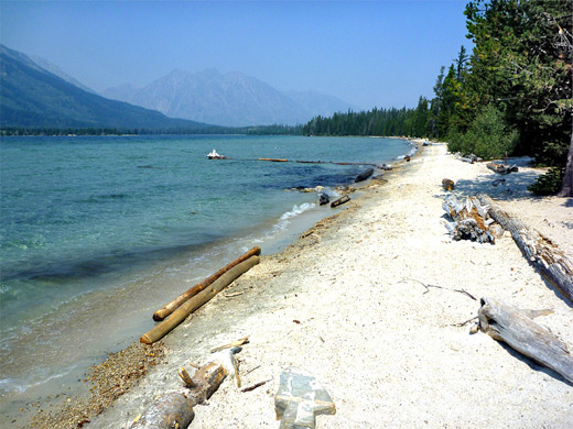
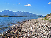
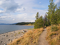
The continuation to Jackson Lake is by another branch of the trail, which follows the Bearpaw Lake exit stream northwards, on the east side. Although unmaintained, this path is as good as all the others; it winds through the forest, initially over flat land then over more rocky terrain, where it crosses to the west side of the creek and ends soon after at Bearpaw Bay on Jackson Lake, a shallow, muddy inlet, overlooked by another primitive camping area. This location is not especially scenic, as the mountains are out of sight, hidden by trees, but they soon come into view when walking northwest along the shoreline, which is narrow and rocky at first, extending round a corner and past a stream, but becomes wider beyond, bordered either by grass or long patches of clean, white, gently sloping sand bearing scattered pieces of driftwood; very ocean-like.
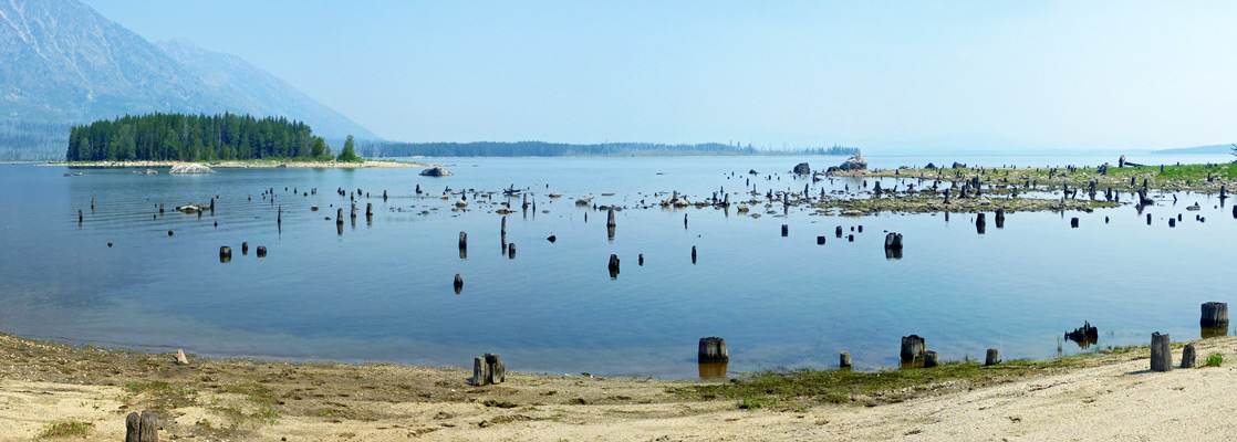
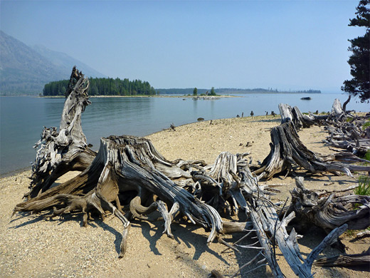
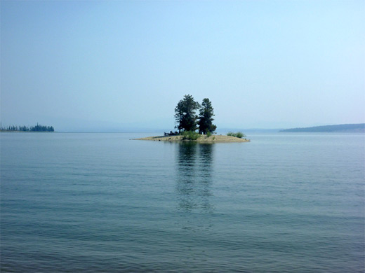
A larger stream joins the lake, flowing into a narrow bay crossed by fallen tree trunks, then beyond are three small islands of increasing size, the second site of the Grassy Island primitive campground, named after the largest of the three, a few hundred feet beyond. This second island is reachable from north or south by wading through water just a couple of feet deep, being separated from the mainland to the west by a shallow, marshy lagoon containing numerous dead tree stumps and often frequented by moose, as is evident from dozens of hoofprints in the sand and mud around the water's edge. Moran Bay is now close by ahead, backed by two large, pathless gorges (Moran Canyon and Snowshow Canyon) between which rises 11,051 foot Traverse Peak. The combination of mountains, lakeshore and the usual lagoon make this one of the most spectacular if little known locations in the national park.
Along the way are white sand beaches, several small islands and an unusual lagoon, lined by marshes and dotted with hundreds of dead tree stumps, more reminiscent of a Louisiana swamp than the Wyoming mountains. The distance to this photogenic point is 6.5 miles, over mostly level ground, and the trip could be extended even more by continuing along the Jackson Lake shoreline to Moran Canyon, and maybe heading upstream. The area around String Lake and the southernmost section of Leigh Lake is usually rather busy but the remainder is much more peaceful, and very few people progress beyond Trapper Lake.

Maps
Location map for Grand Teton National Park. Leigh Lake/Moran Bay topographic map.
Photographs
30 views along the Leigh Lake Trail and Jackson Lake.
Flower pictures along the trail; near Leigh Lake, near Jackson Lake.
Jackson Lake Video
Scenes along the shoreline of Jackson Lake (mp4; 0:57 min; 25 mb).
String Lake and Leigh Lake
The popular String Lake trailhead is reached by a short side road off the Jenny Lake Loop, at the start of its one-way section. The parking lot is nearly empty first thing in the morning but may be full with hundreds of cars on a sunny summer's afternoon. The adjacent String Lake is pretty though certainly not a place for solitude, as the vast majority of visitors stay in the vicinity; swimming, resting on the beaches, walking the 3.3 mile trail that circles the shoreline or padding canoes on the water. From the trailhead, the path leads quickly along the eastern shore to a junction, the left fork being the continuation of the loop and also the way to the backcountry route up Paintbrush Canyon. Another intersection soon after is with a spur used for launching boats on Leigh Lake just to the north. After climbing up and down a narrow range, the right fork of the path proceeds all along the eastern edge of Leigh Lake through shady, rather dry forest where wildflowers are limited, generally staying between 50 and 200 feet from the water, though within easy reach of many tiny beaches and rocky shore access points, plus a few promontories and islands.
Bearpaw Lake
There are several primitive campsites about halfway along Leigh Lake, right by the water, some adjoining narrow sandy beaches and most with views across to Leigh Canyon and the very steep south face of Mount Moran. They have a reputation for being quite frequently visited by bears. The forest becomes thinner, and partly burnt by recent fires towards the north end of the lake, the ground more boulder-covered, and wildflowers more abundant. The trail climbs above the shore and moves away from the lake, curving west through more sparse woodland to an open grassy area, and another intersection, signed Bearpaw Lake right, Trapper Lake straight on; this branch re-enters the forest briefly and soon crosses a small inlet stream of Bearpaw Lake, followed by a slightly larger tributary, near two primitive campsites. The lake is completely wooded and not particularly scenic, at least not when viewed from the western shore where the path leads.
Trapper Lake
From Bearpaw Lake the trail climbs a little over a treeless hillside (better views of the lake from here), crosses a thin belt of woodland and emerges to a meadow at the north end of the prettier Trapper Lake, which has a good sized inlet stream at the north end, originating high above from Skillet Glacier just below the summit of Mount Moran. Beavers have constructed a two-level pond beside the lake. The path ends here, but a loop (with the path signed Bearpaw Lake) can be made by following a fainter, hiker-made route forking off about half way back to this lake, over grassy slopes above the exit drainage and down to the north end of a patch of marshy grassland, crossing the stream via fallen logs, to the north end of the other path, from where the junction near Leigh Lake is half a mile south - along the edge of the grassland beside the stream, then through a short strip of forest.
Jackson Lake - Bearpaw Bay
The continuation to Jackson Lake is by another branch of the trail, which follows the Bearpaw Lake exit stream northwards, on the east side. Although unmaintained, this path is as good as all the others; it winds through the forest, initially over flat land then over more rocky terrain, where it crosses to the west side of the creek and ends soon after at Bearpaw Bay on Jackson Lake, a shallow, muddy inlet, overlooked by another primitive camping area. This location is not especially scenic, as the mountains are out of sight, hidden by trees, but they soon come into view when walking northwest along the shoreline, which is narrow and rocky at first, extending round a corner and past a stream, but becomes wider beyond, bordered either by grass or long patches of clean, white, gently sloping sand bearing scattered pieces of driftwood; very ocean-like.
Jackson Lake - Moran Bay
A larger stream joins the lake, flowing into a narrow bay crossed by fallen tree trunks, then beyond are three small islands of increasing size, the second site of the Grassy Island primitive campground, named after the largest of the three, a few hundred feet beyond. This second island is reachable from north or south by wading through water just a couple of feet deep, being separated from the mainland to the west by a shallow, marshy lagoon containing numerous dead tree stumps and often frequented by moose, as is evident from dozens of hoofprints in the sand and mud around the water's edge. Moran Bay is now close by ahead, backed by two large, pathless gorges (Moran Canyon and Snowshow Canyon) between which rises 11,051 foot Traverse Peak. The combination of mountains, lakeshore and the usual lagoon make this one of the most spectacular if little known locations in the national park.
Leigh Lake and Moran Bay - Similar Hikes
All Contents © Copyright The American Southwest | Comments and Questions | Contribute | Affiliate Marketing Disclosure | Site Map