Mount Tallac Trail
Spectacular route to the highest peak within 3 miles of Lake Tahoe - past two smaller lakes, in forested surroundings, then over open scree slopes to a sloping ridgeline, and along this to the summit. Fantastic views for most of the way, over the main lake to the east and the Desolation Wilderness to the west
Length: 1.6 miles to Floating Island Lake, 2.4 miles to Cathedral Lake, 5 miles to the summit
Elevation change: 800 feet, 1,200 feet, 3,315 feet
Difficulty: Strenuous, to the summit
Type: One way
Usage: Medium to high
Season: Summer and fall
Trailhead: End of a short, paved side road off Hwy 89
Rating (1-5): ★★★★★
Elevation change: 800 feet, 1,200 feet, 3,315 feet
Difficulty: Strenuous, to the summit
Type: One way
Usage: Medium to high
Season: Summer and fall
Trailhead: End of a short, paved side road off Hwy 89
Rating (1-5): ★★★★★

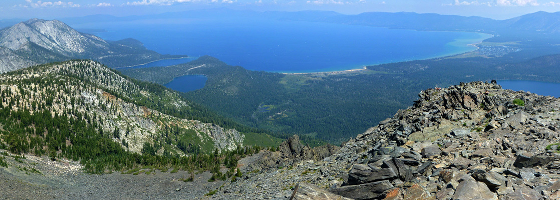
Mount Tallac rises to 9,735 feet just three miles from the edge of Lake Tahoe - the highest summit this close to the lake, and it provides the possibly the best views of the Tahoe Basin, owing to the proximity to several other lakes and the scenic inlet of Emerald Bay. The peak sits between the bay and Fallen Leaf Lake, part of the Desolation Wilderness that covers a large area of Alpine peaks and valleys bordering the southwest section of the main lake, just a few miles from South Lake Tahoe. The closeness to the city, and the easy access make the trail often rather busy, yet it still sees somewhat fewer hikers than nearby routes like Eagle Falls and Glen Alpine, perhaps on account of the relatively strenuous trail - gaining 3,315 feet over 5 miles.
Intermediate destinations include a ridge overlooking Fallen Leaf Lake (1 mile), tree-lined Floating Island Lake (1.6 miles) and the equally pretty Cathedral Lake (2.4 miles), at the treeline, but most people continue all the way to the top. About two thirds of the route is over open slopes, and the views become steadily better, especially at the conclusion of the steepest section, where the path reaches a sloping plateau that extends south from the summit, revealing extensive granite landscapes to the west, at the center of the Desolation Wilderness.
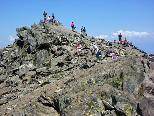
The trail is well maintained, not particularly difficult apart from the steepness though a few sections have loose stones and protruding rocks. Early afternoon on a fine summer's day may see several dozen people on the summit, which is wide and bordered by promontories overlooking different parts of the surroundings.
Mount Tallac Trail topographic map, Southwest Lake Tahoe area map.
25 views along the Mount Tallac Trail.
The Mount Tallac trailhead is at the end of a one mile road, paved but narrow, that forks off Hwy 89 just opposite the turning for Baldwin Beach, 4 miles from the US 50 junction in South Lake Tahoe. The road enters mature forest of large, well separated pine trees, passes two side roads to forest camps and ends at a rather small parking lot. Like others hereabouts, this quickly fills up on popular mornings and cars for later arrivals have to be left up to a quarter of a mile back, on verges.
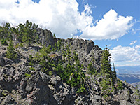
The wide trail sets off through the woodland and climbs gently to the lower end of a narrow, sloping ridge, the top of which is largely free of trees and undergrowth, partly due to a recent wildfire. The ridge gives the first views of Fallen Leaf Lake to the east; to the west, the land slopes down to an overgrown valley then rises steadily beyond, up to the peak. The trail follows the ridgeline, ascending gradually, while the valley floor gains height rather more, so that after a mile, the ridge loses definition, whereupon the path moves away from Fallen Leaf Lake into thicker woods. The initial section is rather uneven underfoot, due to exposed tree roots, loose pebbles and jagged rocks.
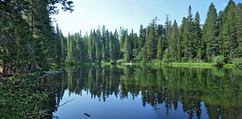
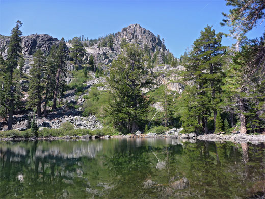
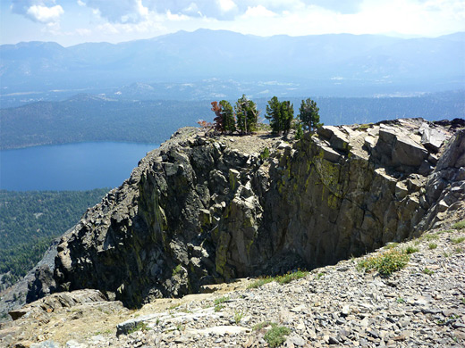
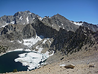
The route next encounters some steeper sections and also a few moister areas filled with thick bushes and long grass, and a better selection of wildflowers than in the predominantly dry woods elsewhere. The trail comes close to a small stream, lined by ferns, and also crosses into the Desolation Wilderness, the boundary marked by a sign. After rising over a minor saddle, the land slopes down slightly to Floating Island Lake, a typically pretty body of water, lined by long green grass and regular pine trunks, with the upper scree slopes of Mount Tallac rising high above. Beyond here, the trail leaves the forest for a while, crossing a boulder pile, and later a mix of wooded and open areas. It passes a junction with a lightly used connecting path down to Fallen Leaf Lake, just before reaching Cathedral Lake, similar in size to Floating Island but more dramatic in appearance, as the slopes on the far side are treeless, formed of granite outcrops and bouldery chutes. This marks the upper edge of the forest, and the remaining 2.6 miles of the hike are above the treeline.
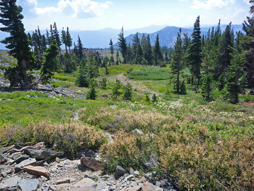
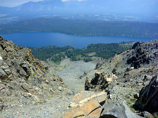
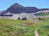
The following section is the steepest; the path rises over an exposed hillside of rocks and small bushes, to a brief flat area of glacier-polished granite, through a patch of trees and up a more extensive scree slope, which leads to a wide, grassy bowl, bordered by higher slopes on three sides. The trail can be seen some distance ahead now, leading to the head of the valley and switchbacking up the hillside beyond, to the rim of the sloping plateau that extends south from the summit. The bowl contains a few tiny streams, good habitat for wildflowers.
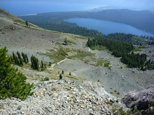
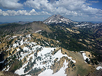
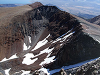
Once on the plateau, much more land comes into view to the north and west - many granite peaks and ridges, and a few more lakes including Aloha and Gilmore. The trail turns right (north), up a shallow valley just below the ridgeline, so the views become temporarily limited. The surroundings are mostly open and grassy, with just a few trees, boulder fields and moister, more overgrown areas. The land becomes increasingly rocky towards the end, especially once past a false summit about half a mile from the actual peak, the top of which is relatively level for a hundred feet or so, and is formed of big, jagged, blocky boulders of dark, metamorphic rock. Several cliff-lined gullies descend very steeply, especially on the north and east sides of the peak. There are no nearby summits so the views are completely unobscured in all directions. The only other junction en route is just below the summit, when a path leads westwards, soon back in forested surrounds, to Gilmore Lake and then Susie Lake, this latter more easily reached from the Glen Alpine trailhead. An partial alternative when returning from Mount Tallac is to walk down the ridgeline a little way east of the path; the views are better but the terrain is quite rough, with extensive boulder piles to cross.
Intermediate destinations include a ridge overlooking Fallen Leaf Lake (1 mile), tree-lined Floating Island Lake (1.6 miles) and the equally pretty Cathedral Lake (2.4 miles), at the treeline, but most people continue all the way to the top. About two thirds of the route is over open slopes, and the views become steadily better, especially at the conclusion of the steepest section, where the path reaches a sloping plateau that extends south from the summit, revealing extensive granite landscapes to the west, at the center of the Desolation Wilderness.
The trail is well maintained, not particularly difficult apart from the steepness though a few sections have loose stones and protruding rocks. Early afternoon on a fine summer's day may see several dozen people on the summit, which is wide and bordered by promontories overlooking different parts of the surroundings.
Maps
Mount Tallac Trail topographic map, Southwest Lake Tahoe area map.
Photographs
25 views along the Mount Tallac Trail.
Mount Tallac Trailhead
The Mount Tallac trailhead is at the end of a one mile road, paved but narrow, that forks off Hwy 89 just opposite the turning for Baldwin Beach, 4 miles from the US 50 junction in South Lake Tahoe. The road enters mature forest of large, well separated pine trees, passes two side roads to forest camps and ends at a rather small parking lot. Like others hereabouts, this quickly fills up on popular mornings and cars for later arrivals have to be left up to a quarter of a mile back, on verges.
Fallen Leaf Lake
The wide trail sets off through the woodland and climbs gently to the lower end of a narrow, sloping ridge, the top of which is largely free of trees and undergrowth, partly due to a recent wildfire. The ridge gives the first views of Fallen Leaf Lake to the east; to the west, the land slopes down to an overgrown valley then rises steadily beyond, up to the peak. The trail follows the ridgeline, ascending gradually, while the valley floor gains height rather more, so that after a mile, the ridge loses definition, whereupon the path moves away from Fallen Leaf Lake into thicker woods. The initial section is rather uneven underfoot, due to exposed tree roots, loose pebbles and jagged rocks.
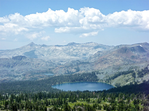
Floating Island Lake and Cathedral Lake
The route next encounters some steeper sections and also a few moister areas filled with thick bushes and long grass, and a better selection of wildflowers than in the predominantly dry woods elsewhere. The trail comes close to a small stream, lined by ferns, and also crosses into the Desolation Wilderness, the boundary marked by a sign. After rising over a minor saddle, the land slopes down slightly to Floating Island Lake, a typically pretty body of water, lined by long green grass and regular pine trunks, with the upper scree slopes of Mount Tallac rising high above. Beyond here, the trail leaves the forest for a while, crossing a boulder pile, and later a mix of wooded and open areas. It passes a junction with a lightly used connecting path down to Fallen Leaf Lake, just before reaching Cathedral Lake, similar in size to Floating Island but more dramatic in appearance, as the slopes on the far side are treeless, formed of granite outcrops and bouldery chutes. This marks the upper edge of the forest, and the remaining 2.6 miles of the hike are above the treeline.
The Steepest Section
The following section is the steepest; the path rises over an exposed hillside of rocks and small bushes, to a brief flat area of glacier-polished granite, through a patch of trees and up a more extensive scree slope, which leads to a wide, grassy bowl, bordered by higher slopes on three sides. The trail can be seen some distance ahead now, leading to the head of the valley and switchbacking up the hillside beyond, to the rim of the sloping plateau that extends south from the summit. The bowl contains a few tiny streams, good habitat for wildflowers.
Path to the Summit
Once on the plateau, much more land comes into view to the north and west - many granite peaks and ridges, and a few more lakes including Aloha and Gilmore. The trail turns right (north), up a shallow valley just below the ridgeline, so the views become temporarily limited. The surroundings are mostly open and grassy, with just a few trees, boulder fields and moister, more overgrown areas. The land becomes increasingly rocky towards the end, especially once past a false summit about half a mile from the actual peak, the top of which is relatively level for a hundred feet or so, and is formed of big, jagged, blocky boulders of dark, metamorphic rock. Several cliff-lined gullies descend very steeply, especially on the north and east sides of the peak. There are no nearby summits so the views are completely unobscured in all directions. The only other junction en route is just below the summit, when a path leads westwards, soon back in forested surrounds, to Gilmore Lake and then Susie Lake, this latter more easily reached from the Glen Alpine trailhead. An partial alternative when returning from Mount Tallac is to walk down the ridgeline a little way east of the path; the views are better but the terrain is quite rough, with extensive boulder piles to cross.
Mount Tallac Wildflowers
More flowers along the trail
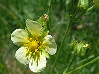 Sierran woodbeauty |
 Mountain bog gentian |
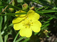 Slender cinquefoil |
More flowers along the trail
Mount Tallac Trail - Similar Hikes
All Contents © Copyright The American Southwest | Comments and Questions | Contribute | Affiliate Marketing Disclosure | Site Map