The national forests and wilderness areas around Lake Tahoe offer many dozens of trails, most climbing high above the water into a landscape of sparse woodland, exposed granite, rocky peaks and glacial lakes. Many trails are long, strenuous and more suited to backpacking trips than day hiking though there are various shorter routes starting along the main road (Highways 89 and 28), including a selection of easier paths in the lakeside state parks.
The best scenery and the most popular hikes are found around the southwest edge of the lake, many within the Desolation Wilderness; these are the routes described below.
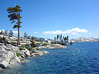
The Southwest Lake Tahoe Map shows the location of each trail.
 |
|||
| Trail | Length (one way) (miles) |
Elevation Change (feet) |
Trail Description |
Lake Tahoe Hikes - Southwest Shore |
|||
| Angora Lakes | 0.5 | 200 | The two Angora Lakes sit in a granite bowl beneath the steep eastern slopes of Angora Peak and Echo Peak, due south of and 1,000 feet above the much larger Fallen Leaf Lake. The trailhead for the short path to the lakes is at the end of the 3 mile Angora Ridge Road, which branches off Fallen Leaf Road - 3 miles from South Lake Tahoe along Highway 89. |
| Bayview | From the Bayview Campground, 7.6 miles from South Lake Tahoe along CA 89, this trail ascends the hillside above Cascade Lake towards Maggies Peaks in the Desolation Wilderness, soon reaching Granite Lake which is a good target for a short hike - all of the path to here has far reaching views over Lake Tahoe. Beyond Granite Lake the path climbs more steeply for a while until it reaches a ridge at 8,440 feet (close to the southernmost of the two peaks), then descends a little to a junction with the Eagle Falls Trail. Various other lakes are then within 2 miles, both on and off trail, including Azure, Dicks and Fontanillis. | ||
| Granite Lake | 1 | 770 | |
| Eagle Falls Trail | 2.5 | 1,560 | |
| Cascade Creek Falls | 1 | 100 | Also starting at the Bayview Campground, a short, well used footpath traverses the pine-covered hillside above Cascade Lake to a 200 foot waterfall along Cascade Creek. A little off trail scrambling is necessary for the best views of the cascade. |
| Clark | 1 | 560 | The Clark Trail climbs steeply up the wooded hillside at the southeast edge of Fallen Leaf Lake to Angora Lookout, a minor summit but high enough for excellent views across the water, and north towards Lake Tahoe. The lookout may also reached by driving along the Angora Ridge Road, a route which continues 1 mile south towards the Angora Lakes. |
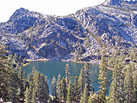
| Eagle Falls | Perhaps the most popular route into the granite backcountry of the Desolation Wilderness starts opposite Emerald Bay, 8.5 miles from South Lake Tahoe. The first short section is often quite busy, as far as Eagle Falls, then the path starts to ascend steadily, passing high above Eagle Lake (reached by a short spur trail) and then after quite a lot more climbing, reaching a wide basin containing Dicks Lake, Fontanillis Lake, and the Upper, Middle & Lower Velma Lakes. The path links with other routes that head west, north and south. Full hike description (to Upper Velma Lake) |
||
| Eagle Falls | 0.25 | 50 | |
| Eagle Lake | 1 | 400 | |
| Bayview Trail | 2.5 | 1,600 | |
| Dicks Lake | 4.5 | 1,800 | |
| Upper Velma Lake | 4.5 | 1,600 | |
| Glen Alpine | One of several routes beginning near Fallen Leaf Lake, the Glen Alpine Trail leads deep into the sparkling granite scenery of the Desolation Wilderness; it begins near one small lake (Lily), climbs steadily up a partly forested valley passing above another (Grass) then splits into several paths that reach further into the backcountry including to 9,735 foot Mt Tallac, and the Aloha, Gilmore, Susie and Heather Lakes. The small parking area for the hike is near the south edge of Fallen Leaf Lake, at the end of a rather narrow road. | ||
| Susie Lake | 3.4 | 1,200 | |
| Gilmore Lake | 3.5 | 1,540 | |
| Heather Lake | 4.3 | 1,340 | |
| Lake Aloha | 5.1 | 1,600 | |
| Mt Tallac | 5 | 3,160 | |
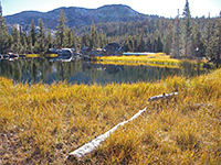
| Moraine | 1 | 50 | This easy trail crosses a forested area of glacial moraine along the north edge of Fallen Leaf Lake, the largest body of water in the Tahoe area apart from the main lake. The path begins at the nearby campground, reached by driving a short distance along Fallen Leaf Road, which forks off CA 89, 3 miles from the US 50 junction in South Lake Tahoe. |
| Meeks Bay | The long distance trail running southwest from Meeks Bay provides one of the main routes into the Desolation Wilderness, though it takes a while before the scenery becomes impressive. The first few miles are along a wide, densely forested ravine, climbing quite gently to the first of several small lakes (Genevieve), where the landscape is rockier and less wooded. The path reaches a high point of 8,880 feet near Phipps Peak and continues south towards the three Velma Lakes. | ||
| Lake Genevieve | 4.5 | 1,160 | |
| Shadow Lake | 5.9 | 1,400 | |
| Rubicon Lake | 8 | 2.060 | |
| Phipps Pass | 9 | 2,560 | |
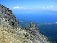
| Mt Tallac | 5 | 3,315 | The slightly shorter of two routes to the top of Mount Tallac starts from the end of a side road along Highway 89, opposite the turn-off for the Baldwin Beach day use area. The path climbs quite gently at first across an open hillside to Floating Island Lake (1.6 miles), then a little more steeply to Cathedral Lake (2.4 miles). This is followed by a much more strenuous ascent up the east face of the mountain, and finally an easier walk along a ridge to the summit. |
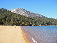
| Rubicon | 6.5 | 400 | The Rubicon Trail links Emerald Bay with Rubicon Point, mostly within the DL Bliss State Park, and all running close to the western shore of Lake Tahoe; sometimes at water level, in other places rising quite high above to avoid sheer sections of the cliffs. The usual starting point is at the north end, near the campground in the state park, and even a short walk gives very good views. The full length extends most of the way around Emerald Bay and also passes Vikingsholm, a replica 38 room Viking castle built at the water's edge close to Fannette Island. |
All Contents © Copyright The American Southwest | Comments and Questions | Contribute | Affiliate Marketing Disclosure | Site Map