Cirque of the Towers
Spectacular glacial basin high in the Wind River Range, surrounded on three sides by a curving line of 12,000 foot granite peaks. Reached by a long but not too difficult hike, mostly on the Big Sandy Trail
Length: 8.5 miles
Elevation change: 1,700 feet
Difficulty: Moderate and fairly level for the first 6 miles, steep and strenuous thereafter
Type: One way
Usage: Low to medium
Season: Summer, early fall
Trailhead: Beside the Big Sandy River
Rating (1-5): ★★★★★
Elevation change: 1,700 feet
Difficulty: Moderate and fairly level for the first 6 miles, steep and strenuous thereafter
Type: One way
Usage: Low to medium
Season: Summer, early fall
Trailhead: Beside the Big Sandy River
Rating (1-5): ★★★★★

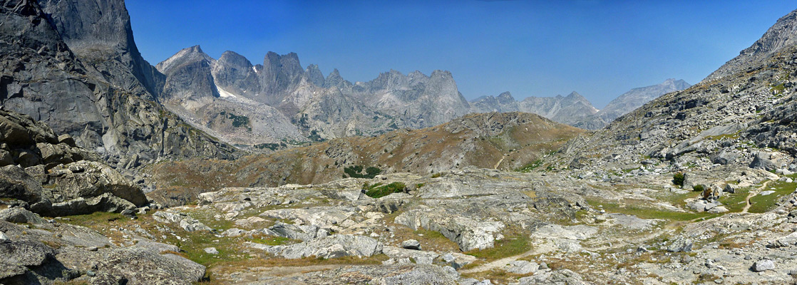
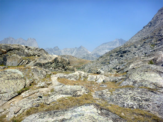
Many unpaved vehicle tracks penetrate a little way into the foothills of the Wind River Range in west Wyoming, but most end ten miles or more from the scenic high country above the timberline. One of the exceptions, and therefore amongst the most popular approaches, leads to a campground and parking area at the start of the Big Sandy Trail, which for five miles leads up a gentle gradient through a mix of meadows and thick pine woods alongside a stream; pleasant if unremarkable scenery, but the landscape becomes much more dramatic at the edge of Big Sandy Lake, as ahead rise stark hillsides of solid rock and scree, sloping steeply to several 12,000 foot summits.
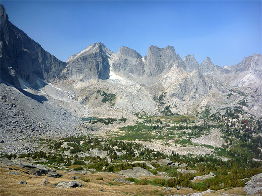
A continuation path ascends more precipitously past two smaller lakes to Jackass Pass at 10,800 feet, in the middle of one of the most spectacular sections of the mountains, equal in grander to anywhere in the more well-known Teton range. This is Cirque of the Towers, a 270° ring of peaks and vertical-walled ridges that contains several glaciers and encloses a large lake in a rocky basin, headwaters of the North Popo Agie River. The hike to this special place is 8.5 miles one way, climbing 1,700 feet, and so possible as a long day trip, perhaps the best such hike in the whole range.
Topographic map of the route.
23 views along the Big Sandy Trail to Cirque of the Towers.
Big Sandy trailhead may be approached from the northwest starting at Boulder along US 191, from the south at Farson, close to the US 191/Hwy 28 junction, and from the southeast, beginning along Hwy 28 at South Pass, the distances being 44, 53 and 35 miles respectively (see overview map). The route from Boulder is eastwards along Hwy 353, a lightly used byway that becomes unpaved after a while but stays wide and smooth so driving speeds are barely affected. The road crosses empty land of grassy, sagebrush plains and small hills, containing very few side tracks or signs of habitation. The designation changes to Hwy 118, known as Big Sandy-Elkhorn Road, and as it continues the surface eventually becomes a little bumpier, but still relatively good - and the surroundings just as desolate - until the reaching southern start point near Farson.
One of several major junctions along Big Sandy-Elkhorn Road is with the west end of Lander Cutoff Road (reached 27 miles from Boulder, 36 miles from Farson), which is also wide and smooth, running southeastwards for 32 miles to the Hwy 28 junction at South Pass. The next intersection on the route to Big Sandy is 7 miles along here (25 miles from Hwy 28) with BLM 4113, from where the campground and trailhead are 10.7 miles due north. This track is ok at first, crossing the valley of Squaw Creek and climbing over a ridge into a grassy basin, where it passes the Bridger-Teton National Forest boundary and starts to climb into the woods, following a small creek. The road narrows and becomes stony, and ridged in places, staying similar for the remainder of the way, but is more uneven towards the end, especially in a few short steep places.
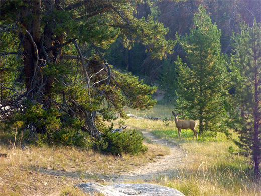
The track crosses another stream, returns to the forest and eventually comes out to a large meadow, where a few side roads branch off, including one to Big Sandy Lodge, which provides basic, rustic lodging between late May and early October. The final section of the road is through a patch of woodland to the trailhead parking, which often fills up so vehicles have to be left on verges up to a quarter mile or more away. The USFS Big Sandy Campground (fees $24 per night in 2024) is situated on the far side, only containing 12 sites but these are usually not all taken as there are many nicer, free camping spots all along the road, some right next to the stream. Peaks on the mountain crest are visible in the distance above the trees, otherwise the surroundings are not especially exciting at this point. Cows frequent the area and around the first few miles of the trail.
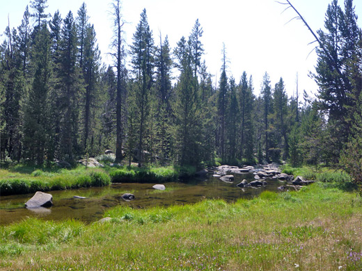
The path begins in wooded surroundings beside the Big Sandy River, crosses a moist, grassy area and passes a junction with a lesser used route to Meeks Lake (and many places beyond), then rounds a bend in the river and has a brief, rocky ascent before becoming straight and fairly level, encountering more grassland and a sign marking the boundary of the Bridger Wilderness. The trail returns to the woods, staying a little way above the river but soon emerges into the open again, close to the slow-moving waters. After a longer climb, still quite gentle, the route moves away from the river, instead following a tributary stream, and reaches a second junction, with a path that heads back southwest to Diamond Lake (0.2 miles), the larger V Lake (1.5 miles) and then Meeks Lake (2.5 miles), thus providing an alternative way back to the trailhead.
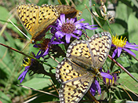
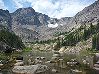
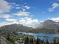
The main path continues, crossing the stream, as the surroundings become rockier, the gradient a bit steeper, and the forest more fragmented. Five miles from the trailhead, the path emerges to grass and reeds at the west end of Big Sandy Lake, then moves along the north shore through sparse woodland and into much bigger grassy flats, speckled with many summer wildflowers. White granite boulders are strewn across the meadow, and high granite cliffs rise all around, sloping up to smooth-sided peaks including Bunion Mountain to the west, Shiestler Peak to the south and the higher summits of the Continental Divide to the north. The lake is the day hike destination for some, and is also a popular place to camp (permissible 100 feet or more from the shoreline), especially with people fishing, or using the valley as a base from which to climb further into the mountains.
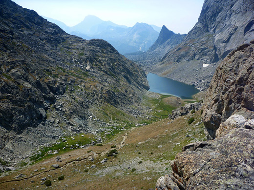
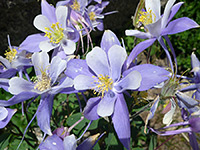
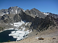
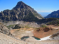
The path to Cirque of the Towers (signed to Jackass Pass) forks off northwards at the north edge of Big Sandy Lake, starting with a steep switchbacking climb of 300 feet through light woodland, into a pretty, grass-covered bowl enclosing a small stream (North Creek), with extensive granite slopes above on each side. A few tiny tributaries flow down the hillside, lined with pink Lewis monkeyflowers. The trail descends a little, crosses North Creek and rises up a boulder/slickrock slope on the far side, soon giving views of an unnamed lake below. A faint path descends to the water's edge but the main route stays higher up, crossing a big pile of jagged boulders and a steep rock face that extends to the lake, before dropping down to a boggy area at the east end of the lake, home to many wildflower species - less common varieties at these higher elevations include queen's crown, Colorado columbine and fringed grass of parnassus. The next steep climb leads up a rocky slope bearing just a few trees and then along the west side of a sloping ridgeline where the woodland finally stops. A saddle is reached directly above beautiful Arrowhead Lake (not yet visible), after which the trail descends nearly 200 feet and climbs again across an earthen slope to 10,800 foot Jackass Pass; an off-trail alternative to this final section is to traverse the granite slopes to the right of the saddle, staying fairly level, and rejoining the trail at the pass.
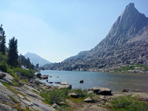
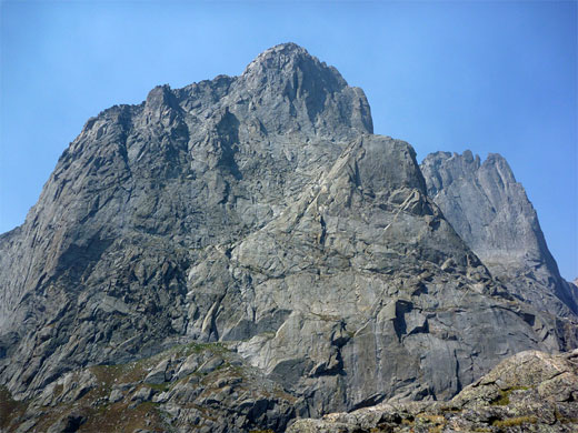
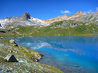
A sign at Jackass Pass marks the edge of the adjacent Popo Agie Wilderness, and the trail continues by descending 700 feet then following the North Popo Agie River downstream, eventually meeting a trailhead along Moccasin Lake Road, but the pass is the a destination for most hikers as this sits on the rim of the Cirque of the Towers, one of the most spectacular places in all the Rocky Mountains. The best views are from a small summit 200 feet southwest of the pass. Lonesome Lake lies directly below, at the head of the river valley, surrounded on three sides by steepening slopes, which hold a cascading stream, several smaller lakes and four glaciers, while above is the curving mountain crest and a group of stark, 12,000 foot granite peaks - Mitchell, War Bonnet, Warrior, Pylon, Watchtower, Block Tower, Wolfs Head and Lizard Head, plus others unnamed.
A continuation path ascends more precipitously past two smaller lakes to Jackass Pass at 10,800 feet, in the middle of one of the most spectacular sections of the mountains, equal in grander to anywhere in the more well-known Teton range. This is Cirque of the Towers, a 270° ring of peaks and vertical-walled ridges that contains several glaciers and encloses a large lake in a rocky basin, headwaters of the North Popo Agie River. The hike to this special place is 8.5 miles one way, climbing 1,700 feet, and so possible as a long day trip, perhaps the best such hike in the whole range.
Map
Topographic map of the route.
Photographs
23 views along the Big Sandy Trail to Cirque of the Towers.
Cirque of the Towers Access - Big Sandy Trailhead
Big Sandy trailhead may be approached from the northwest starting at Boulder along US 191, from the south at Farson, close to the US 191/Hwy 28 junction, and from the southeast, beginning along Hwy 28 at South Pass, the distances being 44, 53 and 35 miles respectively (see overview map). The route from Boulder is eastwards along Hwy 353, a lightly used byway that becomes unpaved after a while but stays wide and smooth so driving speeds are barely affected. The road crosses empty land of grassy, sagebrush plains and small hills, containing very few side tracks or signs of habitation. The designation changes to Hwy 118, known as Big Sandy-Elkhorn Road, and as it continues the surface eventually becomes a little bumpier, but still relatively good - and the surroundings just as desolate - until the reaching southern start point near Farson.

Lander Cuttoff Road
One of several major junctions along Big Sandy-Elkhorn Road is with the west end of Lander Cutoff Road (reached 27 miles from Boulder, 36 miles from Farson), which is also wide and smooth, running southeastwards for 32 miles to the Hwy 28 junction at South Pass. The next intersection on the route to Big Sandy is 7 miles along here (25 miles from Hwy 28) with BLM 4113, from where the campground and trailhead are 10.7 miles due north. This track is ok at first, crossing the valley of Squaw Creek and climbing over a ridge into a grassy basin, where it passes the Bridger-Teton National Forest boundary and starts to climb into the woods, following a small creek. The road narrows and becomes stony, and ridged in places, staying similar for the remainder of the way, but is more uneven towards the end, especially in a few short steep places.
Big Sandy Trailhead
The track crosses another stream, returns to the forest and eventually comes out to a large meadow, where a few side roads branch off, including one to Big Sandy Lodge, which provides basic, rustic lodging between late May and early October. The final section of the road is through a patch of woodland to the trailhead parking, which often fills up so vehicles have to be left on verges up to a quarter mile or more away. The USFS Big Sandy Campground (fees $24 per night in 2024) is situated on the far side, only containing 12 sites but these are usually not all taken as there are many nicer, free camping spots all along the road, some right next to the stream. Peaks on the mountain crest are visible in the distance above the trees, otherwise the surroundings are not especially exciting at this point. Cows frequent the area and around the first few miles of the trail.
Path from the Trailhead
The path begins in wooded surroundings beside the Big Sandy River, crosses a moist, grassy area and passes a junction with a lesser used route to Meeks Lake (and many places beyond), then rounds a bend in the river and has a brief, rocky ascent before becoming straight and fairly level, encountering more grassland and a sign marking the boundary of the Bridger Wilderness. The trail returns to the woods, staying a little way above the river but soon emerges into the open again, close to the slow-moving waters. After a longer climb, still quite gentle, the route moves away from the river, instead following a tributary stream, and reaches a second junction, with a path that heads back southwest to Diamond Lake (0.2 miles), the larger V Lake (1.5 miles) and then Meeks Lake (2.5 miles), thus providing an alternative way back to the trailhead.
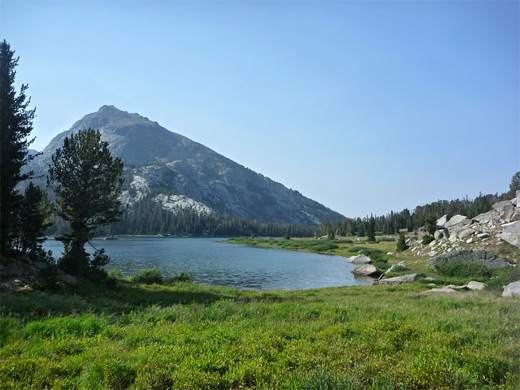
Big Sandy Lake
The main path continues, crossing the stream, as the surroundings become rockier, the gradient a bit steeper, and the forest more fragmented. Five miles from the trailhead, the path emerges to grass and reeds at the west end of Big Sandy Lake, then moves along the north shore through sparse woodland and into much bigger grassy flats, speckled with many summer wildflowers. White granite boulders are strewn across the meadow, and high granite cliffs rise all around, sloping up to smooth-sided peaks including Bunion Mountain to the west, Shiestler Peak to the south and the higher summits of the Continental Divide to the north. The lake is the day hike destination for some, and is also a popular place to camp (permissible 100 feet or more from the shoreline), especially with people fishing, or using the valley as a base from which to climb further into the mountains.
Big Sandy Lake to Jackass Pass
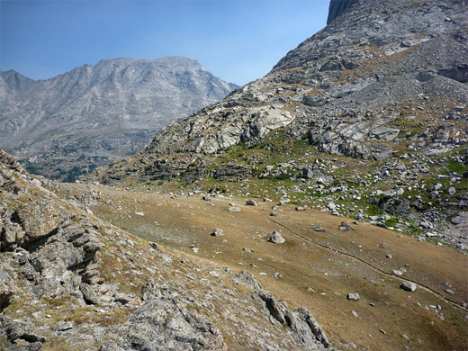
The path to Cirque of the Towers (signed to Jackass Pass) forks off northwards at the north edge of Big Sandy Lake, starting with a steep switchbacking climb of 300 feet through light woodland, into a pretty, grass-covered bowl enclosing a small stream (North Creek), with extensive granite slopes above on each side. A few tiny tributaries flow down the hillside, lined with pink Lewis monkeyflowers. The trail descends a little, crosses North Creek and rises up a boulder/slickrock slope on the far side, soon giving views of an unnamed lake below. A faint path descends to the water's edge but the main route stays higher up, crossing a big pile of jagged boulders and a steep rock face that extends to the lake, before dropping down to a boggy area at the east end of the lake, home to many wildflower species - less common varieties at these higher elevations include queen's crown, Colorado columbine and fringed grass of parnassus. The next steep climb leads up a rocky slope bearing just a few trees and then along the west side of a sloping ridgeline where the woodland finally stops. A saddle is reached directly above beautiful Arrowhead Lake (not yet visible), after which the trail descends nearly 200 feet and climbs again across an earthen slope to 10,800 foot Jackass Pass; an off-trail alternative to this final section is to traverse the granite slopes to the right of the saddle, staying fairly level, and rejoining the trail at the pass.
Cirque of the Towers
A sign at Jackass Pass marks the edge of the adjacent Popo Agie Wilderness, and the trail continues by descending 700 feet then following the North Popo Agie River downstream, eventually meeting a trailhead along Moccasin Lake Road, but the pass is the a destination for most hikers as this sits on the rim of the Cirque of the Towers, one of the most spectacular places in all the Rocky Mountains. The best views are from a small summit 200 feet southwest of the pass. Lonesome Lake lies directly below, at the head of the river valley, surrounded on three sides by steepening slopes, which hold a cascading stream, several smaller lakes and four glaciers, while above is the curving mountain crest and a group of stark, 12,000 foot granite peaks - Mitchell, War Bonnet, Warrior, Pylon, Watchtower, Block Tower, Wolfs Head and Lizard Head, plus others unnamed.

Cirque of the Towers - Similar Hikes
All Contents © Copyright The American Southwest | Comments and Questions | Contribute | Affiliate Marketing Disclosure | Site Map