Highlights:
Pretty, easily accessible canyon through the foothills of the Santa Catalina Mountains; a very popular recreation center for Tucson residents. A permanent stream flows through the ravine, forming pools and waterfalls; followed by a popular trail. Adjacent Bear Canyon has similar scenery
Nearby town:
Tucson, 7 miles
Management:
USFS - part of Coronado National Forest
Location:
Seasons:
All year; best in spring when water levels are highest. Summers are hot
Rating (1-5):
★★★★★
Weather:

Featured Hotel
Comfort Suites at Sabino Canyon
 Five miles south of Sabino Canyon along Tanque Verde Road; a relaxing hotel built around four elegant courtyards containing mature gardens with an outdoor pool
Check Rates
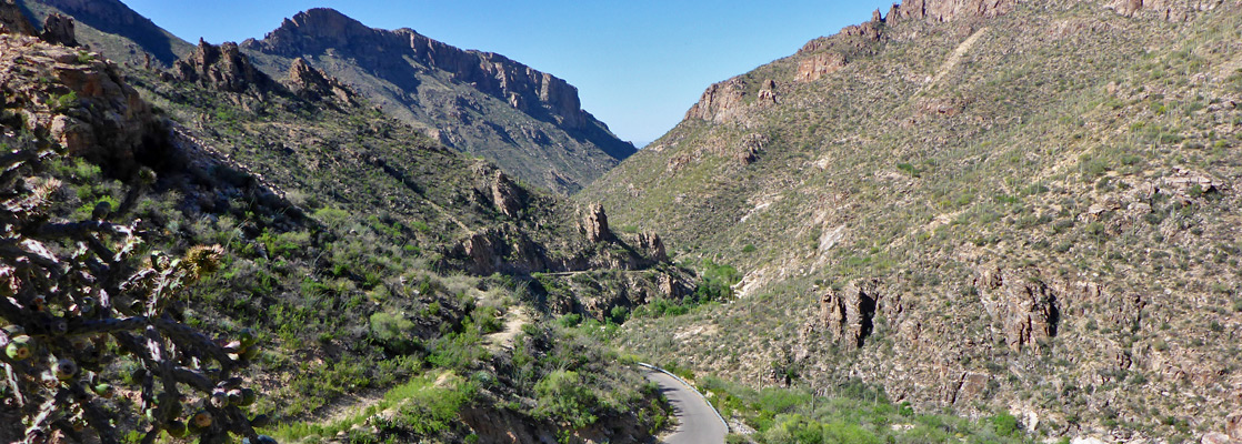
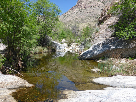
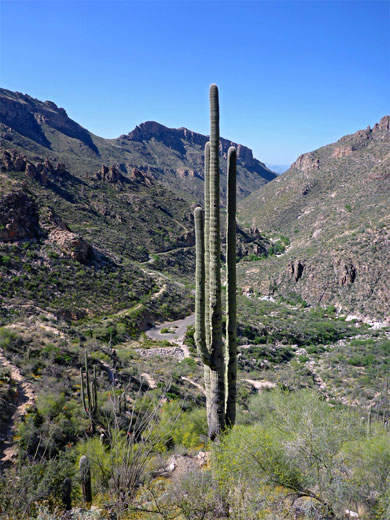
The saguaro-draped foothills of the Santa Catalina Mountains north of Tucson harbor countless scenic ravines but two of the prettiest are Sabino Canyon and Bear Canyon, ten miles northeast of the city center. Both feature a stream that forms seasonal pools and waterfalls, steep-sided slopes bearing many cacti and other Sonoran Desert plants, with rocky peaks rising high above. Of the two, Sabino is more developed and more visited, having a paved road running 3.8 miles up the lower section, along which are various picnic sites, trailheads and viewpoints.
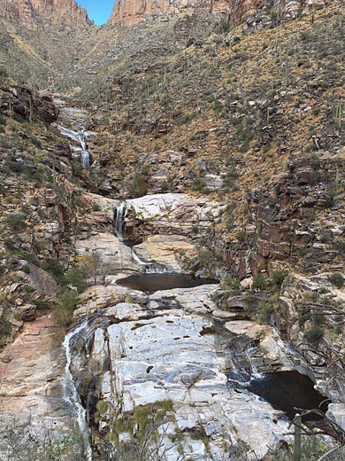
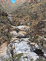
Another paved road reaches the mouth of Bear Canyon then a trail continues upstream, and although the landscape in both is similar, Sabino Canyon receives more water so is generally a greener, cooler place, as the streamway is more shaded, and the pools persist longer; in midsummer, both canyons are usually dry. When wet, however, Bear Canyon has the single most impressive feature, Seven Falls, where the waters cascade down a steep ravine creating an enchanting sequence of waterfalls and pools.
Another paved road reaches the mouth of Bear Canyon then a trail continues upstream, and although the landscape in both is similar, Sabino Canyon receives more water so is generally a greener, cooler place, as the streamway is more shaded, and the pools persist longer; in midsummer, both canyons are usually dry. When wet, however, Bear Canyon has the single most impressive feature, Seven Falls, where the waters cascade down a steep ravine creating an enchanting sequence of waterfalls and pools.
Sabino Canyon Table of Contents
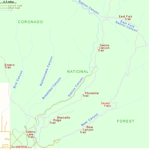
- Sabino Canyon map
- Photographs
- Access and facilities
- Sabino Canyon
- Bear Canyon
- Trails of the recreation area
- Nearby places
- Similar places
Map of Sabino Canyon Recreation Area
Sabino Canyon Access and Facilities
Both ravines are part of the Sabino Canyon Recreation Area, a very popular if rather commercial and domesticated place. To get there from Interstate 10 requires quite a lengthy drive right across town, aiming for the north-south Sabino Canyon Road which crosses the usually dry Tanque Verde Wash and then a range of low hills before reaching the large parking area for the canyons. This is located at the edge of an upmarket residential area, with houses nestled in the surrounding hills right up to the park fence, yet all this urban land is still quite densely covered in bushes and cacti.
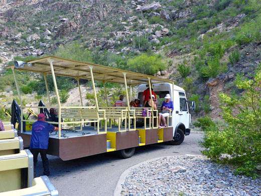
Since 1978 private vehicles have been prohibited on the roads to Sabino or Bear Canyons; instead visitors may travel by tram, bicycle, horseback or on foot. Parking (2024) is $8 per vehicle, while tours on the tram are charged at $15/$8 for adults/children for Sabino Canyon, or $8/$5 for Bear Canyon. Next to the carpark are a visitor center, bookshop, vending machines, (free) drinking water supply, and many people - this is often quite a crowded location, especially popular with local residents who come for jogging and cycling. For them, a yearly pass is available for $20, and all fees are good for other nearby sites in the Coronado National Forest including all those along the road to the summit of Mount Lemmon.
Sabino Canyon
Trams leave the visitor center every 30 minutes for the journey into Sabino Canyon, stopping at nine places along the way. The full trip takes about 45 minutes, crosses the creek nine times on sturdy stone bridges, and is made to the accompaniment of narration from a tour guide, who gives details of the local wildlife, plant life, geology and history. The trams are certainly the most popular way to visit, though many prefer to walk or cycle. Of the various paths in the area, one starts next to the carpark - the short, self-guided Desert Nature Trail - which has informative notices about local plants and animals. Others are found along the Sabino Canyon Road; the Phoneline Trail (#27) is perhaps the most popular, starting 1.4 miles from the visitor center by climbing up the south side of the canyon then following it for several miles, before descending to the far end of the road, where it intersects the Sabino Canyon Trail (#23), a continuation route further north into the mountains. Another short path, the Sabino Lake Trail (#30), leads to a seasonal reservoir along Sabino Creek, a good location for bird watching.
Bear Canyon
Bear Canyon and the Seven Falls can be explored by a relatively easy 5 mile round trip hike beginning at the end of the side road, reachable by tram - or 8.5 miles if starting from the visitor center, a walk that in season is one of the most scenic in all Arizona.
Sabino Canyon Trails
Bear Canyon Trail
★★★★★
★★★★★
2.2 miles, 600 feet
Popular route up a rocky canyon holding a permanent stream and lined by many cacti, to the base of the Seven Falls, a group of pools and cascades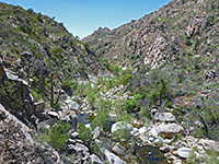
Sabino Canyon Trail
★★★★★
★★★★★
2.5 miles, 500 feet
Path further up Sabino Canyon, beyond the end of the tram road; leads to a tributary stream, where several other trails branch offSabino Canyon - Nearby Places
- Catalina State Park (17 miles) - campground and short trails in the Santa Catalina foothills
- Mount Lemmon (36 miles to the summit) - central peak of the Santa Catalina Mountains
- Saguaro National Park (13 miles to the east section) - dense forests of the saguaro, plus many other cacti
Sabino Canyon - Similar Places
- Kaiser Spring Canyon - beautiful desert canyon north of Wickenburg
- Tonto Creek - permanent desert stream containing deep pools and waterfalls
All Contents © Copyright The American Southwest | Comments and Questions | Contribute | Affiliate Marketing Disclosure | Site Map