Moonflower Canyon
A short, wooded Colorado River tributary along Kane Creek Road southwest of Moab, ending at a pool below towering cliffs. At the canyon mouth are several petroglyph panels
Length: 0.4 miles
Elevation change: 160 feet
Difficulty: Easy
Type: One-way
Usage: Medium
Season: All year
Trailhead: Parking area along Kane Creek Road, 3 miles from Moab
Rating (1-5): ★★★★★
Elevation change: 160 feet
Difficulty: Easy
Type: One-way
Usage: Medium
Season: All year
Trailhead: Parking area along Kane Creek Road, 3 miles from Moab
Rating (1-5): ★★★★★

Moonflower Canyon is a short tributary of the Colorado River, 3 miles southwest of Moab, so-named for the large white flowers of datura wrightii (sacred datura, or moonflower) which grow here, typically opening in the evenings. Moonflower is a box canyon, flanked by orange-brown walls of Navajo sandstone, and containing a small seasonal stream which creates a moist environment sustaining cottonwood trees and much other vegetation, all sheltered and shady due to the tall cliffs and the east-west orientation.
Rocks around the mouth of the Colorado River canyon this side of Moab are initially from the Chinle, Wingate and Kayenta groups, transitioning to Navajo sandstone just north of Moonflower Canyon. At the head of the box canyon are vertical cliffs of around 150 feet, above which, mostly out of sight, is a narrow bench, and then more cliffs, even taller; beyond here, the seasonal stream flows over open, flattish land, originating as two forks around the upper end of Hidden Valley.
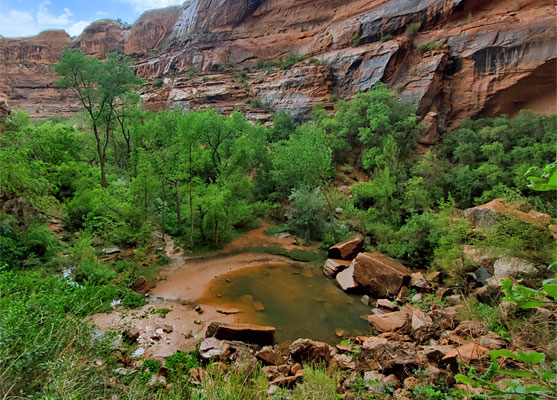
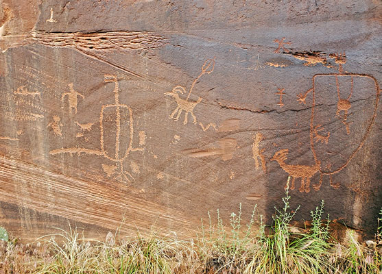
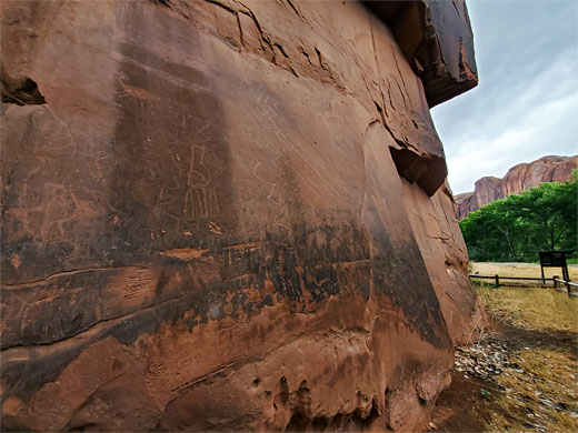
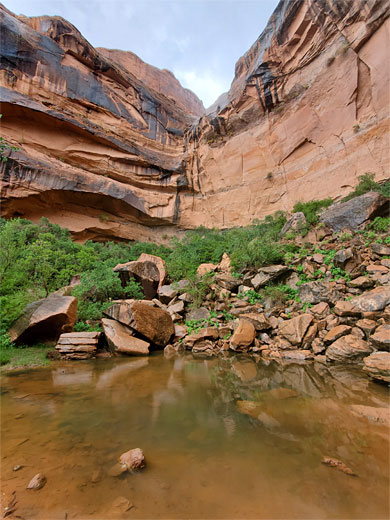
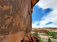
Moonflower Canyon is explored via a 0.4 mile trail, and is of interest for two reasons; the riparian corridor, including a large pool at the upper end, and for several panels of petroglyphs at the entrance, at the base of low cliffs right beside the access road.
Moab area map.
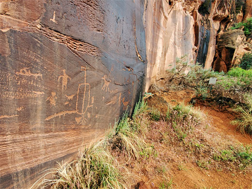
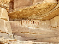
Moonflower Canyon is reached by the paved Kane Creek Road, just past Kane Bottom Campground, and is served by a good-sized parking area, beneath large cottonwood trees. The petroglyphs are to the south side, fenced off for protection, extending 100 feet or so. Some are faded, others quite large and relatively crisp, reflecting the different ages, from many centuries BC to around 1300 AD. Like most of the rock art along Kane Creek Road, the designs are marred by modern graffiti. One other attraction here, just east of the petroglyphs beside the end of the wooden fence, is a narrow crack in the cliffs into which logs have been positioned, allowing people to climb up to the bench above, ascending around 50 feet.
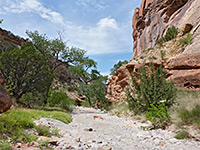
The Moonflower Canyon Trail first passes an eight-site, walk-in BLM campground (tents only), on sandy ground, then runs along the north side of the drainage over a grassy, rocky slope, a little way above the line of trees beside the streambed. It descends into the wooded area, crosses the stream and ends beside the large pour-over pool at the head of the drainage, at the base of a bouldery slope, with the sheer Navajo cliffs on three sides. This is a good wildflower location, including moonflowers, and at least one rare species, Mancos columbine, growing from seeps above the pool.
Rocks around the mouth of the Colorado River canyon this side of Moab are initially from the Chinle, Wingate and Kayenta groups, transitioning to Navajo sandstone just north of Moonflower Canyon. At the head of the box canyon are vertical cliffs of around 150 feet, above which, mostly out of sight, is a narrow bench, and then more cliffs, even taller; beyond here, the seasonal stream flows over open, flattish land, originating as two forks around the upper end of Hidden Valley.
Moonflower Canyon is explored via a 0.4 mile trail, and is of interest for two reasons; the riparian corridor, including a large pool at the upper end, and for several panels of petroglyphs at the entrance, at the base of low cliffs right beside the access road.

Location
Moab area map.
Rock Art
Moonflower Canyon is reached by the paved Kane Creek Road, just past Kane Bottom Campground, and is served by a good-sized parking area, beneath large cottonwood trees. The petroglyphs are to the south side, fenced off for protection, extending 100 feet or so. Some are faded, others quite large and relatively crisp, reflecting the different ages, from many centuries BC to around 1300 AD. Like most of the rock art along Kane Creek Road, the designs are marred by modern graffiti. One other attraction here, just east of the petroglyphs beside the end of the wooden fence, is a narrow crack in the cliffs into which logs have been positioned, allowing people to climb up to the bench above, ascending around 50 feet.

The Canyon
The Moonflower Canyon Trail first passes an eight-site, walk-in BLM campground (tents only), on sandy ground, then runs along the north side of the drainage over a grassy, rocky slope, a little way above the line of trees beside the streambed. It descends into the wooded area, crosses the stream and ends beside the large pour-over pool at the head of the drainage, at the base of a bouldery slope, with the sheer Navajo cliffs on three sides. This is a good wildflower location, including moonflowers, and at least one rare species, Mancos columbine, growing from seeps above the pool.
Moonflower Canyon - Similar Hikes
All Contents © Copyright The American Southwest | Comments and Questions | Contribute | Affiliate Marketing Disclosure | Site Map