Hidden Lake, Kanab
An unusual, permanently flooded alcove at the base of a colorful cliff of stripy, orange-white Navajo sandstone, along the shallow canyon of Kanab Creek, next to the Best Friends Animal Sanctuary
Length: 0.8 miles
Elevation change: 160 feet
Difficulty: Easy
Type: One way
Usage: Medium
Season: All year
Trailhead: Track along Kanab Canyon Road. 4WD vehicles can drive right to the cave
Rating (1-5): ★★★★★
Elevation change: 160 feet
Difficulty: Easy
Type: One way
Usage: Medium
Season: All year
Trailhead: Track along Kanab Canyon Road. 4WD vehicles can drive right to the cave
Rating (1-5): ★★★★★

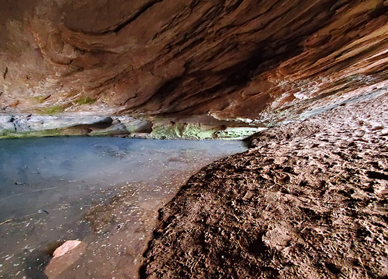
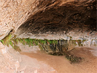
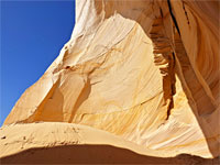
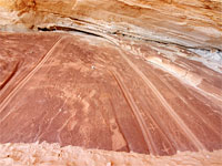
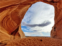
Hidden Lake (or Underground Lake), a BLM recreation site, is an elongated alcove at the base of a stripy, orange-white cliff of Navajo Sandstone, on the east side of the shallow canyon of Kanab Creek, seven miles north of Kanab. The alcove is close to land of the Best Friends Animal Sanctuary, the largest refuge for unwanted animals in the US, home to upwards of 1,500 dogs, cats, horses, rabbits and other creatures.
The cave is permanently flooded, containing a long pool of water, sometimes clear, on other occasions dark and murky, presumably fed by a spring, and while not especially exciting to look at, the surrounding sandstone cliffs are photogenic, especially when contrasted with the dark green leaves of the adjacent mature cottonwood trees.
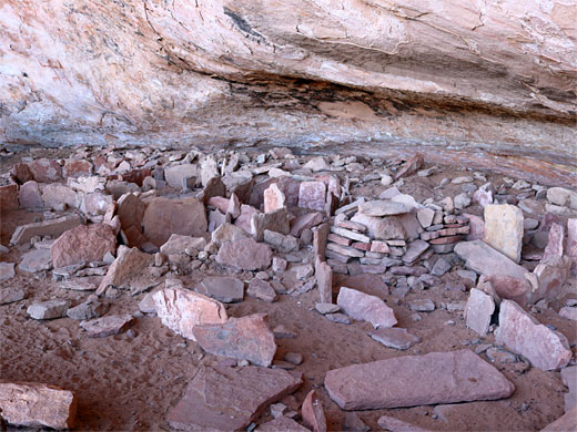
200 feet from the cave is a small picnic area, at the end of the access track, which may require a 4WD vehicle to reach because of the rough surface over the last quarter of a mile, and a steep sandy slope near the start, so an alternative is to hike from just before this slope, starting around the point where the track crosses Kanab Creek; an easy hike of 0.8 miles, climbing 160 feet. Also of interest, in another alcove a short distance north of the cave, is a small ancient site, containing some low wall remnants, and rock art including a red pictograph.
The flooded cave is reached from the road to the animal sanctuary, which forks north off US 89, following Kanab Creek, and is paved up to the sanctuary then wide gravel beyond. After the main buildings it passes Horse Haven, the equine refuge, and several meadows, after which (3 miles from US 89) is a junction with a lesser track, road 2600; this descends to the creek, crossing it just as the stream is contained within a short slot section. Beside the bridge is a parking place, for 2WD vehicles.
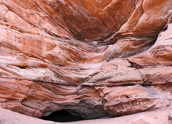
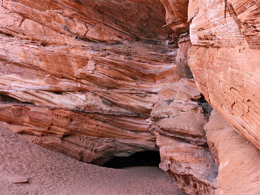
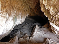
Past the bridge, the track turns south, climbs a slope, which becomes sandy near the top, then reaches a four-way junction. Road 2600 climbs further, out of the canyon, while the cave is reached by the two tracks that continue south; they rejoin after a short distance, then the continuation track curves west, past a field, into a little side valley, to the cave. This latter section is lined by trees, and is quite shady and moist. The cliffs hereabouts are around 100 feet high, and the cave has formed at the lower boundary of the Navajo sandstone, where it meets the underlying Kayenta formation.
The westernmost of the two tracks is the most direct route; the easternmost curves to and from the cliffs, passing another alcove that contains the minor ruin site, with the rock art, which is unfortunately mixed with some modern graffiti. The ruin is fenced off and in recent years a trail camera has been installed, to deter any further damage.
The cave is permanently flooded, containing a long pool of water, sometimes clear, on other occasions dark and murky, presumably fed by a spring, and while not especially exciting to look at, the surrounding sandstone cliffs are photogenic, especially when contrasted with the dark green leaves of the adjacent mature cottonwood trees.
200 feet from the cave is a small picnic area, at the end of the access track, which may require a 4WD vehicle to reach because of the rough surface over the last quarter of a mile, and a steep sandy slope near the start, so an alternative is to hike from just before this slope, starting around the point where the track crosses Kanab Creek; an easy hike of 0.8 miles, climbing 160 feet. Also of interest, in another alcove a short distance north of the cave, is a small ancient site, containing some low wall remnants, and rock art including a red pictograph.

Hidden Lake Video

Hidden Lake Access
The flooded cave is reached from the road to the animal sanctuary, which forks north off US 89, following Kanab Creek, and is paved up to the sanctuary then wide gravel beyond. After the main buildings it passes Horse Haven, the equine refuge, and several meadows, after which (3 miles from US 89) is a junction with a lesser track, road 2600; this descends to the creek, crossing it just as the stream is contained within a short slot section. Beside the bridge is a parking place, for 2WD vehicles.
Hike to the Lake
Past the bridge, the track turns south, climbs a slope, which becomes sandy near the top, then reaches a four-way junction. Road 2600 climbs further, out of the canyon, while the cave is reached by the two tracks that continue south; they rejoin after a short distance, then the continuation track curves west, past a field, into a little side valley, to the cave. This latter section is lined by trees, and is quite shady and moist. The cliffs hereabouts are around 100 feet high, and the cave has formed at the lower boundary of the Navajo sandstone, where it meets the underlying Kayenta formation.
Ancient Ruin
The westernmost of the two tracks is the most direct route; the easternmost curves to and from the cliffs, passing another alcove that contains the minor ruin site, with the rock art, which is unfortunately mixed with some modern graffiti. The ruin is fenced off and in recent years a trail camera has been installed, to deter any further damage.

Hidden Lake - Similar Places
All Contents © Copyright The American Southwest | Comments and Questions | Contribute | Affiliate Marketing Disclosure | Site Map