

Great Chamber, Kanab
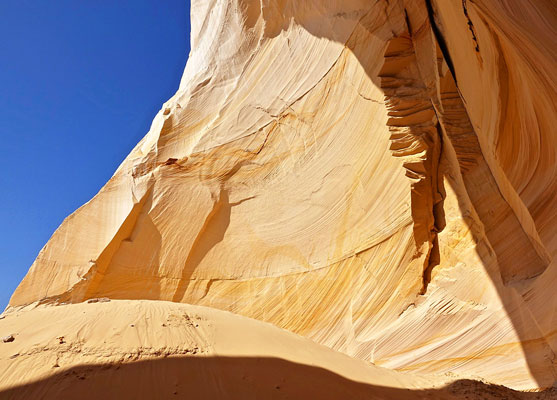
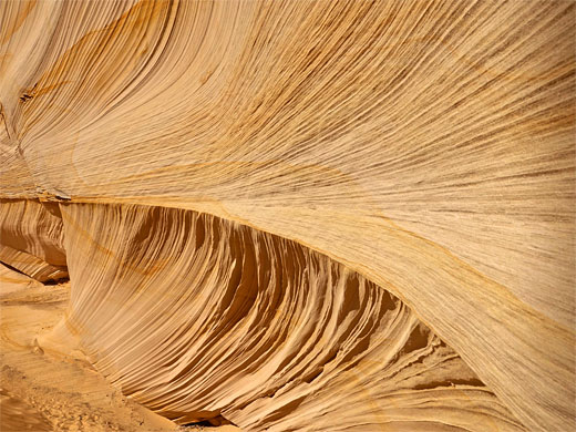
Huge, south-facing alcove eroded into the southern tip of a narrow promontory (Cutler Point), framed by curving, thin-layered, subtly-colored walls of Temple Cap Sandstone. A recently-popularized location, good for photography
Length: 0.3 miles, from the 4WD parking area, otherwise 4 miles
Elevation change: 200 feet, or 700 feet
Difficulty: Easy, or moderate
Type: One way
Usage: Low
Season: All year, though hot in summer, and potentially snowy in winter
Trailhead: On the southwest side of Cutler Point, along sandy tracks north of Kanab; 4WD required
Rating (1-5): ★★★★★
Elevation change: 200 feet, or 700 feet
Difficulty: Easy, or moderate
Type: One way
Usage: Low
Season: All year, though hot in summer, and potentially snowy in winter
Trailhead: On the southwest side of Cutler Point, along sandy tracks north of Kanab; 4WD required
Rating (1-5): ★★★★★


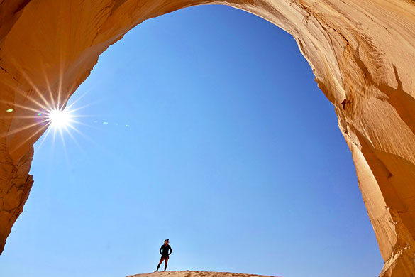
The Great Chamber is one of a number of recently-popularized photogenic locations across the Southwest, essentially unknown before around ten years ago. The chamber, or alcove, at least 200 feet across, has eroded into the base of the cliffs on the southern tip of Cutler Point (named Singali Point on older maps), a promontory projecting off the main section of the Skutumpah Terrace, 10 miles northwest of Kanab.
The place is both beautiful in itself, because of the textures and colors of the rock walls, and it provides amazing views. The chamber, also known as Cutler Cove, is formed by wind rather than water, similar to some other Southwest erosional formations like the Nautilus and the Cosmic Ashtray, both of which are also now quite well-known.
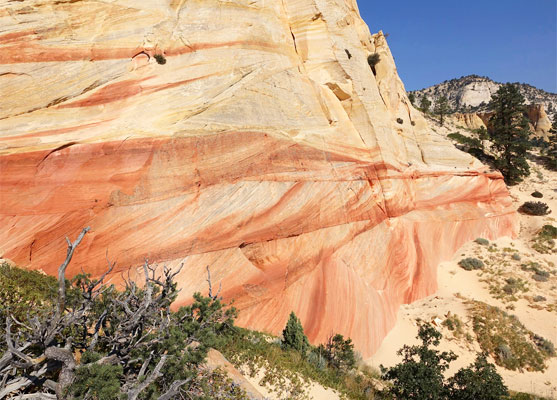
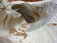
The floor of the chamber is occupied by a huge sand dune (though rather less high than it used to be, due to the activities of hikers and sandboarders), while to the sides are thin-layered strata at a variety of angles, subtly colored in shades of pink and yellow. The overall hue is off-white - the point forms part of the White Cliffs, the middle of the five layers of the Grand Staircase, and it is visible from a distance along Hwy 89 to the south.
The cliffs of Cutler Point are composed of the White Throne Member of the Temple Cap Sandstone, and contain large-scale cross-bedding, similar to the underlying Navajo sandstone, the bedrock of the sandy plain south of the chamber. Rocks on the uppermost section of the point are from the Carmel Formation.
A sandy track comes within a quarter of a mile of the Great Chamber, so people with high clearance, 4WD vehicles can approach this close, after an 8.3 mile drive from Johnson Canyon Road in the east or 9.3 miles from Kanab Canyon Road in the west. Otherwise, the shortest hike from a paved road is 4 miles, mostly off-trail, across relatively flat terrain.
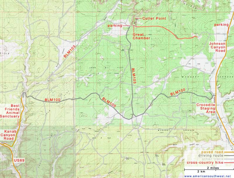
The eastern, most used driving route to the Great Chamber starts from the Crocodile Staging Area along Johnson Canyon Road, 8 miles north of US 89 - a parking place with BLM map and information board, often used by ATV riders, heading for trails around Hog Canyon a few miles southwest. The chamber is reached by driving west for 4.3 miles, along BLM 100, then north for 4 miles along BLM 103, to a parking place below Cutler Point. The first sandy stretch occurs quite close to the start, so the route is definitely for 4WD only. There are two fences with gates which require opening and closing along the drive. All the land is fairly open and flat, once past a little ridge at the start, and the point is always visible off to the north.
The western approach is along Kanab Canyon Road, which forks northwards off US 89 (at the parking place for the Kanab Sand Caves) and is paved for 1.3 miles, to a little way beyond the Best Friends Animal Sanctuary, then becomes gravel. A side road crosses the canyon streambed and climbs very steeply to the plateau beyond; this road is BLM 100, and reaches the aforementioned junction with BLM 103 in 6 miles, the surface similarly sandy in many places. The journey is completed by the 4.3 mile northwards drive, on BLM 103. A shortcut is provided a lesser road (the continuation of BLM 103) that forks off northeast, just beyond the climb from Kanab Canyon, leading more directly to the chamber, but this is rougher and narrower in some places, more of an ATV track.
If walking to the Great Chamber, a 4 mile hike, the suggested start point is 2.6 miles north of the Crocodile Staging Area, parking on the east side of Johnson Canyon Road opposite a farm; a track runs just north of the farm buildings, westwards along the edge of a field, into public lands and up a slope to the top of a low ridge, where it ends. On the far side of the ridge, from where Cutler Point is clearly visible, 2.5 miles ahead, the land slopes gently down to a shallow drainage, Dry Lake Canyon. The cross-country route is into this canyon, upstream a little way then west, gradually ascending over more sandy, bushy land to the base of the point.
From the 4WD parking place at Cutler Point, the end of a little spur off BLM 103, a short path runs east along the base of the cliffs and ascends a sandy slope to the quite steep sand dune on the floor of the Great Chamber. Views to the south are very extensive, across to the distant cliffs of the Grand Canyon, 50 miles away. The foreground is mostly featureless, the bushy flats interrupted only by one jagged knoll of Navajo sandstone, named Red Butte.
The place is both beautiful in itself, because of the textures and colors of the rock walls, and it provides amazing views. The chamber, also known as Cutler Cove, is formed by wind rather than water, similar to some other Southwest erosional formations like the Nautilus and the Cosmic Ashtray, both of which are also now quite well-known.
The floor of the chamber is occupied by a huge sand dune (though rather less high than it used to be, due to the activities of hikers and sandboarders), while to the sides are thin-layered strata at a variety of angles, subtly colored in shades of pink and yellow. The overall hue is off-white - the point forms part of the White Cliffs, the middle of the five layers of the Grand Staircase, and it is visible from a distance along Hwy 89 to the south.
The cliffs of Cutler Point are composed of the White Throne Member of the Temple Cap Sandstone, and contain large-scale cross-bedding, similar to the underlying Navajo sandstone, the bedrock of the sandy plain south of the chamber. Rocks on the uppermost section of the point are from the Carmel Formation.
A sandy track comes within a quarter of a mile of the Great Chamber, so people with high clearance, 4WD vehicles can approach this close, after an 8.3 mile drive from Johnson Canyon Road in the east or 9.3 miles from Kanab Canyon Road in the west. Otherwise, the shortest hike from a paved road is 4 miles, mostly off-trail, across relatively flat terrain.
Map of Routes to the Great Chamber
Approach to the Great Chamber from the East
The eastern, most used driving route to the Great Chamber starts from the Crocodile Staging Area along Johnson Canyon Road, 8 miles north of US 89 - a parking place with BLM map and information board, often used by ATV riders, heading for trails around Hog Canyon a few miles southwest. The chamber is reached by driving west for 4.3 miles, along BLM 100, then north for 4 miles along BLM 103, to a parking place below Cutler Point. The first sandy stretch occurs quite close to the start, so the route is definitely for 4WD only. There are two fences with gates which require opening and closing along the drive. All the land is fairly open and flat, once past a little ridge at the start, and the point is always visible off to the north.
Approach to the Great Chamber from the West
The western approach is along Kanab Canyon Road, which forks northwards off US 89 (at the parking place for the Kanab Sand Caves) and is paved for 1.3 miles, to a little way beyond the Best Friends Animal Sanctuary, then becomes gravel. A side road crosses the canyon streambed and climbs very steeply to the plateau beyond; this road is BLM 100, and reaches the aforementioned junction with BLM 103 in 6 miles, the surface similarly sandy in many places. The journey is completed by the 4.3 mile northwards drive, on BLM 103. A shortcut is provided a lesser road (the continuation of BLM 103) that forks off northeast, just beyond the climb from Kanab Canyon, leading more directly to the chamber, but this is rougher and narrower in some places, more of an ATV track.
Hiking to the Great Chamber
If walking to the Great Chamber, a 4 mile hike, the suggested start point is 2.6 miles north of the Crocodile Staging Area, parking on the east side of Johnson Canyon Road opposite a farm; a track runs just north of the farm buildings, westwards along the edge of a field, into public lands and up a slope to the top of a low ridge, where it ends. On the far side of the ridge, from where Cutler Point is clearly visible, 2.5 miles ahead, the land slopes gently down to a shallow drainage, Dry Lake Canyon. The cross-country route is into this canyon, upstream a little way then west, gradually ascending over more sandy, bushy land to the base of the point.
Tours to the Great Chamber
The Chamber
From the 4WD parking place at Cutler Point, the end of a little spur off BLM 103, a short path runs east along the base of the cliffs and ascends a sandy slope to the quite steep sand dune on the floor of the Great Chamber. Views to the south are very extensive, across to the distant cliffs of the Grand Canyon, 50 miles away. The foreground is mostly featureless, the bushy flats interrupted only by one jagged knoll of Navajo sandstone, named Red Butte.
Great Chamber - Similar Places
All Contents © Copyright The American Southwest | Comments and Questions | Contribute | Affiliate Marketing Disclosure | Site Map