Nautilus Rock, Grand Staircase-Escalante National Monument
Utah > Grand Staircase-Escalante National Monument > Nautilus Rock
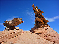
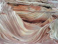
Nautilus Rock
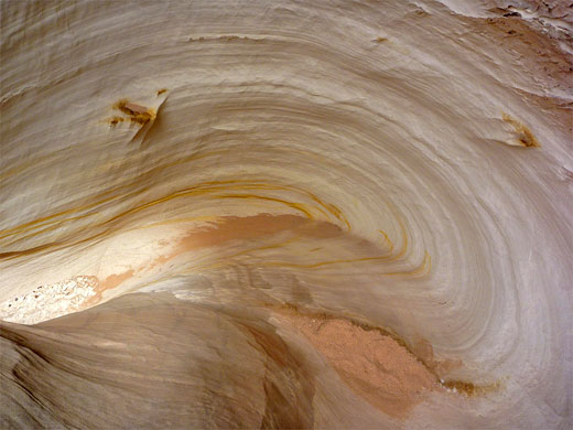
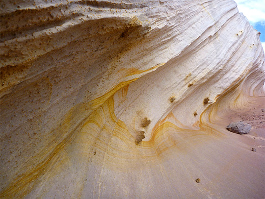
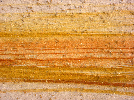
Shell-shaped outcrop of Page sandstone, split by a curving, wave-like gully, lined by thin, delicate fins and ridges; a very photogenic location. Most of the rock is white or grey in color, but enlivened by small patches of red and yellow
Length: 1.1 miles
Elevation change: 130 feet
Difficulty: Easy
Type: One way, cross-country
Usage: Low
Season: All year
Trailhead: Parking area along US 89, used for the Paria Rimrocks
Rating (1-5): ★★★★★
Elevation change: 130 feet
Difficulty: Easy
Type: One way, cross-country
Usage: Low
Season: All year
Trailhead: Parking area along US 89, used for the Paria Rimrocks
Rating (1-5): ★★★★★

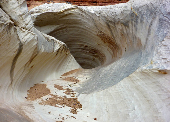
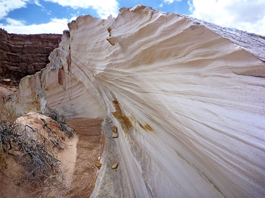
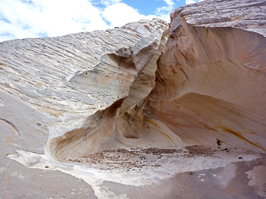
The Nautilus, or Nautilus Rock, is the recently bestowed, semi-official name of a beautiful formation of wind and water-eroded Page sandstone, at the edge of a small tributary ravine near the Paria River, 9 miles northeast of the equally photogenic Wave. The feature is a smooth-sided outcrop of soft, thin-layered rock with a rippled surface texture, cut by a corkscrew-like gully, which curves downwards and sideways, reminiscent of a gastropod shell.
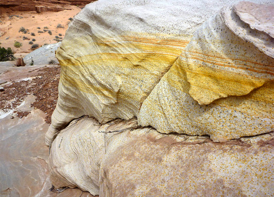
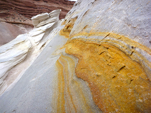
Occasional splashes of red, yellow and orange add color to the otherwise white or light grey sandstone, and some parts of the sides of the mound and walls of the gully are weathered into delicate, thin, narrow fins and ridges. Other parts of the surface have a course texture of small, spherical sandstone granules, while the majority is quite smooth. The location is just over a mile from the BLM Paria ranger station, where staff know of the site and urge caution when visiting, owing to be easily damaged formations. It is probably best that people view that gully from above and below rather than walk through, to avoid breaking the narrow fins or marking the light-colored sandstone.
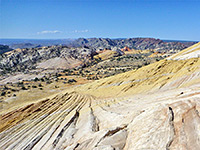
One possible start point is the main parking area for the Paria Rimrocks on the north side of US 89, a location relatively busy in peak season. The route to the formation is south, across the highway, through a gate and along a shallow, winding, sandy wash, which deepens after half a mile via a sudden drop-off, soon becoming enclosed by 50 foot cliffs. There are not many climb down places, but when found the descent is straightforward; the best is a little way downstream on the west side. Not far beyond, another, larger, drainage joins from the east and the rocks around the streamway change from the usual reddish-brown cliffs (the Carmel Formation) to undulating mounds of grey, white or pale red Page sandstone, landscape that extends to the junction with the much wider Paria River valley, visible half a mile ahead. A second option is to walk or drive from the Paria River trailhead, 1.5 miles down a sometimes rough track until it approaches the river, opposite the junction with the Nautilus drainage; the rock is then half a mile northeast.
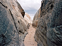
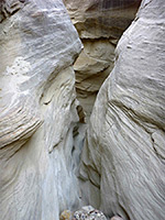
The Nautilus lies on the southeast side of the drainage, just west of a little tributary. The low white cliff on the north side of the outcrop is also quite pretty, with the same crisp, thin-layered texture as is found around the central gully, looking as if it has only recently been created. The main part of the formation is just beyond; a graceful, swirling gap through the sandstone mound, mostly colored pure white but speckled with tiny yellow dots and crossed by thin lines of red and orange. The gully looks good, and different, from all angles. There are several smaller areas of the same grey sandstone nearby, and a few other interesting eroded formations. The place is best photographed on a partly or totally cloudy day, to avoid harsh shadows falling across the crevice, which is never fully illuminated due to overhanging rocks above. Most of the surface of the Nautilus has a regular rippled texture, betraying its origin as a petrified sand dune. 0.43 miles south is a similar but slightly wider curved gap in the same grey rock, which may also be worthy of investigation.
Occasional splashes of red, yellow and orange add color to the otherwise white or light grey sandstone, and some parts of the sides of the mound and walls of the gully are weathered into delicate, thin, narrow fins and ridges. Other parts of the surface have a course texture of small, spherical sandstone granules, while the majority is quite smooth. The location is just over a mile from the BLM Paria ranger station, where staff know of the site and urge caution when visiting, owing to be easily damaged formations. It is probably best that people view that gully from above and below rather than walk through, to avoid breaking the narrow fins or marking the light-colored sandstone.
Approach to Nautilus Rock
One possible start point is the main parking area for the Paria Rimrocks on the north side of US 89, a location relatively busy in peak season. The route to the formation is south, across the highway, through a gate and along a shallow, winding, sandy wash, which deepens after half a mile via a sudden drop-off, soon becoming enclosed by 50 foot cliffs. There are not many climb down places, but when found the descent is straightforward; the best is a little way downstream on the west side. Not far beyond, another, larger, drainage joins from the east and the rocks around the streamway change from the usual reddish-brown cliffs (the Carmel Formation) to undulating mounds of grey, white or pale red Page sandstone, landscape that extends to the junction with the much wider Paria River valley, visible half a mile ahead. A second option is to walk or drive from the Paria River trailhead, 1.5 miles down a sometimes rough track until it approaches the river, opposite the junction with the Nautilus drainage; the rock is then half a mile northeast.
The Rock
The Nautilus lies on the southeast side of the drainage, just west of a little tributary. The low white cliff on the north side of the outcrop is also quite pretty, with the same crisp, thin-layered texture as is found around the central gully, looking as if it has only recently been created. The main part of the formation is just beyond; a graceful, swirling gap through the sandstone mound, mostly colored pure white but speckled with tiny yellow dots and crossed by thin lines of red and orange. The gully looks good, and different, from all angles. There are several smaller areas of the same grey sandstone nearby, and a few other interesting eroded formations. The place is best photographed on a partly or totally cloudy day, to avoid harsh shadows falling across the crevice, which is never fully illuminated due to overhanging rocks above. Most of the surface of the Nautilus has a regular rippled texture, betraying its origin as a petrified sand dune. 0.43 miles south is a similar but slightly wider curved gap in the same grey rock, which may also be worthy of investigation.
Nautilus Rock - Similar Hikes
All Contents © Copyright The American Southwest | Comments and Questions | Contribute | Affiliate Marketing Disclosure | Site Map